Heart puzzle red and stethoscope on wooden background. Concept diagnosis and treatment of heart disease, medical insurance
Heart puzzle red and stethoscope on wooden background. Concept diagnosis and treatment of heart disease, medical insurance

Asian beautiful women stressful and headache after working with a laptop for a long time.Hand holding the face After taking a headache medicat…

beautiful woman trying on clothes shop shopaholic isolated background. High quality photo

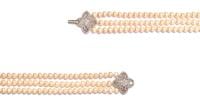
Triple strand freshwater pearl necklace with platinum hook set with diamonds on white background. Collection of luxury jewelry accessories. St…

Close up view of happy woman clean home or restaurant. She wiping dust using spray and orange fabric cleaning on dirty table. House keeping ma…
Join us for a powerful and inspiring true story of addiction and the strength of family love. Discover the impact of the film 'Beautiful Boy,'…

The western entrance of the historic picturesque small town of Easton, MD, center of Talbot County. A landmark with coat of arms is erected on…
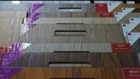
When it comes to giving a makeover to parts or all of your home, you won’t regret swinging into Shorely Beautiful in Cambridge. Katie stops buy to show us the selection of flooring, tiles, rugs, wallpaper, fabric, and window treatments.