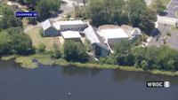
Wicomico County’s main library is one step closer to a new home, with state funding helping move forward renovations at the former Ward Museum…
From
To


A smiling Indian student with a backpack stands confidently outside a modern building, with arms crossed

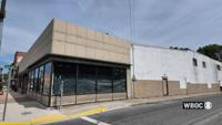
A long-vacant downtown Pocomoke City building is moving closer to new life after city officials approved final site plans for a mixed-use rede…

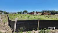
The Accomack County Board of Zoning Appeals affirmed an earlier stop-work order from the Zoning Administrator on the construction of a battery…


Asian man engineer using talkie walkie report working at rooftop building construction. Technician worker working checking hvac of office buil…

selective focus of building with windows near rooftop


View of the Commerce Square (Praca do Comercio) and the Rua Augusta triumphal arch, in the city of Lisbon, Portugal, at dusk.


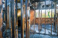
Burned home after fire the parts of the house after burnning