  • Facebook
  • Twitter
  • LinkedIn
  • YouTube
  • Instagram
  • Sign Up
  • Log In
  • Dashboard
  • Logout
    • My Account
    • Dashboard
    • Profile
    • Saved items
    • Logout
Home
  • About WBOC
  • Our Team
  • Programming
  • Contact Us
  • Careers
  • Internships
  • Policies
  • Report It
  • Get our newsletters
  • WBOC Apps
News
  • Wicomico County
  • Worcester County
  • Somerset County
  • Dorchester County
  • Caroline County
  • Talbot County
  • Queen Annes County
  • Sussex County
  • Kent County
  • Accomack County
  • National News
  • International News
  • Latest Newscasts
  • Video Center
Weather
  • Forecast
  • Radar
  • Satellite
  • On The Waters
  • Weather Cameras
  • Closings
Delmarva Sports Network
Shows
  • DelmarvaLife
  • Outdoors Delmarva
  • Delmarva Home Show
Features
  • Obituaries
  • Heartbeat of Delmarva
  • Proud To Serve
  • The M Report
  • Farming Our Future
  • Farm to Table Scholarship
  • Bless Our Children
  • Events: Shore Living Expo
Radio
  • 100.9% Classic Country WAAI
  • 107.1 The Duck
  • 102.5 WBOC FM
  • 93.5 The Beach
  • 107.7 BIG Classic Rock
  • 103.9 and 106.3 Coast Country
  • Watch Live
  • Apps
  • Contact Us
  • My Account
  • Sign Up
  • Log In
  • Dashboard
  • Logout
    • My Account
    • Dashboard
    • Profile
    • Saved items
    • Logout
  • Facebook
  • Twitter
  • LinkedIn
  • YouTube
  • Instagram
  • 73° Cloudy
    • Salisbury, MD (21801)

      Today

      A few showers this morning with numerous thunderstorms developing during the afternoon hours. High 82F. Winds ESE at 5 to 10 mph. Chance of rain 60%. Locally heavy rainfall possible..

      Tonight

      Mostly cloudy skies. Slight chance of a rain shower. Low 71F. Winds NE at 10 to 15 mph.

      Updated: August 20, 2025 @ 8:05 am

    • Full Forecast
site-logo
Watch Live

Newscast Schedule

View Programming Schedule
site-logo
  • 73°
  • Home
  • News
    • Wicomico County
    • Worcester County
    • Somerset County
    • Dorchester County
    • Caroline County
    • Talbot County
    • Queen Annes County
    • Sussex County
    • Kent County
    • Accomack County
    • National News
    • International News
    • Latest Newscasts
    • Video Center
    • Report It
  • Weather
    • Forecast
    • Radar
    • Satellite
    • On The Waters
    • Weather Cameras
    • Closings
  • Delmarva Sports Network
  • Shows
    • DelmarvaLife
    • Outdoors Delmarva
    • Delmarva Home Show
  • Features
    • Obituaries
    • Heartbeat of Delmarva
    • The M Report
    • Proud To Serve
    • Farming Our Future
    • Farm to Table Scholarship
    • Jefferson Awards
    • Delmarva Experts
    • Bless Our Children
    • Events: Shore Living Expo
  • Radio
    • 100.9% Classic Country WAAI
    • 107.1 The Duck
    • 93.5 The Beach
    • 107.7 BIG Classic Rock
    • 103.9 and 106.3 Coast Country
    • 102.5 WBOC FM
  • About Us
    • About WBOC
    • Our Team
    • Channel Finder
    • Apps
    • Contact Us
    • Get our newsletters
    • Careers
    • Internships
    • Policies
    • WBOC Solar Farm
Broadcast Schedule

On air schedule

Weather Alert

Weather Alert

This product covers CENTRAL AND EASTERN VIRGINIA...NORTHEAST NORTH
CAROLINA...AND THE LOWER MARYLAND EASTERN SHORE

**TROPICAL STORM WATCH UPGRADED TO A WARNING FROM DUCK, NC TO THE
VIRGINIA NORTH CAROLINA BORDER**

NEW INFORMATION
---------------

* CHANGES TO WATCHES AND WARNINGS:
- The Tropical Storm Watch has been upgraded to a Tropical Storm
Warning for Eastern Currituck and Western Currituck

* CURRENT WATCHES AND WARNINGS:
- A Tropical Storm Warning is in effect for Eastern Currituck and
Western Currituck
- A Tropical Storm Watch is in effect for Accomack, Northampton,
and Virginia Beach

* STORM INFORMATION:
- About 660 miles south of Ocean City MD or about 580 miles
south-southeast of Norfolk VA
- 28.9N 73.3W
- Storm Intensity 100 mph
- Movement North-northwest or 345 degrees at 13 mph

SITUATION OVERVIEW
------------------

Hurricane Erin, currently northeast of the Bahamas, will gradually
turn northward with the center of the storm remaining well offshore of
the Mid-Atlantic coast. However, Erin is expected to grow in size
which may allow for tropical storm conditions to impact areas close to
the coast from the Virginia Eastern Shore, Virginia Beach, Currituck
County, as well as the Maryland, Virginia and northeast North Carolina
Coastal Waters, the Chesapeake Bay, and lower James River. Winds of 30
to 40 mph with gusts to 45 mph are possible close to the coast south
of Chincoteague, with winds of 30 to 35 kt with gusts to 35 to 45 kt
possible over the water.

Regardless of the exact track, Erin is expected to bring high surf,
significant dune and beach erosion and moderate to locally major tidal
flooding to the area. Seas will increase to 12 to 18 feet over the
coastal waters by Thursday which will allow for significant beach and
dune erosion for the coast especially around the times of high tide on
Thursday morning and Thursday evening. In addition, moderate to
locally major coastal flooding is expected during the Thursday
afternoon and evening high tide with inundation of 1 to 3 feet above
normally high ground. A coastal flood watch is in effect for the
entire area bordering the Virginia waters of the Chesapeake Bay, the
tidal rivers of eastern Virginia, and the Atlantic coastline from
Corolla, NC to Ocean City, MD.

POTENTIAL IMPACTS
-----------------

* SURGE:
Protect against locally hazardous surge having possible limited
impacts across all of the shoreline from Maryland through Virginia to
NE North Carolina, including the lower and middle Chesapeake Bay.
Potential impacts in this area include:
- Widespread storm surge flooding of vulnerable areas will result
in an elevated threat of property damage to homes and
businesses near the waterfront and shoreline.
- Sections of low-lying vulnerable roads, parking lots and
property will likely become flooded. Driving conditions could
become dangerous in places where flooding covers the road.
- Moderate to severe beach erosion is likely, including heavy surf
possibly breaching dunes, especially in vulnerable locations.
Strong and dangerous rip currents are expected.
- Minor to moderate damage to marinas, docks, boardwalks, and
piers is likely. A few small craft broken away from moorings.

Elsewhere across CENTRAL AND EASTERN VIRGINIA...NORTHEAST NORTH
CAROLINA...AND THE LOWER MARYLAND EASTERN SHORE, little to no impact
is anticipated.

* OTHER COASTAL HAZARDS:
Along the Atlantic coast from Fenwick Island Delaware to Duck North
Carolina, expect waves to build to 12 to 18 ft by Thursday morning.
These large waves combined with increased water levels will likely
allow for significant beach and dune erosion. There is a high risk of
rip currents along the shoreline through Friday.

* WIND:
Protect against hazardous wind having possible limited impacts across
the area close to the shoreline from Chincoteague VA to Duck NC.
Potential impacts in this area include:
- Damage to porches, awnings, carports, sheds, and unanchored
mobile homes. Unsecured lightweight objects blown about.
- Many large tree limbs broken off. A few trees snapped or
uprooted, especially if soils are saturated. Some roadway signs
will sustain damage.
- A few roads will be impassable from debris. Hazardous driving
conditions on bridges and other elevated roadways.
- Scattered power and communications outages.

Elsewhere across CENTRAL AND EASTERN VIRGINIA...NORTHEAST NORTH
CAROLINA...AND THE LOWER MARYLAND EASTERN SHORE, little to no impact
is anticipated.

PRECAUTIONARY/PREPAREDNESS ACTIONS
----------------------------------

* EVACUATIONS:
A mandatory evacuation for the off-road area of Corolla effective at 9
AM EDT Wednesday August 20th.

* OTHER PREPAREDNESS INFORMATION:
When making safety and preparedness decisions, do not focus on the
exact forecast track since hazards such as flooding rain, damaging wind
gusts, storm surge, and tornadoes extend well away from the center of
the storm.

Always heed the advice of local officials and comply with orders that
are issued. Do not needlessly jeopardize your life or the lives of
others.

Closely monitor weather.gov, NOAA Weather Radio and local news outlets
for official storm information. Listen for possible changes to the
forecast.

* ADDITIONAL SOURCES OF INFORMATION:
- For information on appropriate preparations see
www.readyvirginia.gov, readync.org or mema.maryland.gov
- For the latest weather and storm information go to
weather.gov/wakefield

NEXT UPDATE
-----------

The next local statement will be issued by the National Weather
Service in Wakefield VA around 12 PM EDT, or sooner if conditions
warrant.

Weather Alert

...SMALL CRAFT ADVISORY IN EFFECT FROM 8 PM THIS EVENING TO 6 AM
EDT THURSDAY...

* WHAT...Northeast winds 10 to 20 kt with gusts up to 25 kt
expected.

* WHERE...Chesapeake Bay from Drum Point MD to Smith Point VA,
Tidal Potomac from Cobb Island MD to Smith Point VA and
Tangier Sound and the inland waters surrounding Bloodsworth
Island.

* WHEN...From 8 PM this evening to 6 AM EDT Thursday.

* IMPACTS...Conditions will be hazardous to small craft.

PRECAUTIONARY/PREPAREDNESS ACTIONS...

Inexperienced mariners, especially those operating smaller
vessels, should avoid navigating in hazardous conditions.

&&

eclipse


Closings

Click here to view closings and delays

Advanced Search Close Search
From
To
Close Search
2:16
Future of Hearn Building in Downtown Cambridge Takes a Step Forward
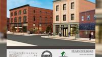
Latest News

Future of Hearn Building in Downtown Cambridge Takes a Step Forward

  • Lauren Miller
  • Updated Jun 4, 2024

The aim is to transform the historic structure into a mixed-use building.

site-logo
  • Facebook
  • Twitter
  • LinkedIn
  • YouTube
  • Instagram

Sections

  • Latest Newscasts
  • Local News
  • Weather
  • Features
  • DelmarvaLife
  • Outdoors Delmarva
  • Delmarva Home Show
  • CoastTV
  • Telemundo Delmarva
  • Delmarva Sports Network
  • Video Center

Services

  • Search
  • Pay My Bill
  • Advertise With Us
  • Contact Us
  • Careers
  • Internships

Browser Compatibility

Your browser is out of date and potentially vulnerable to security risks.
We recommend switching to one of the following browsers:

Microsoft Edge Google Chrome Firefox
FCC Public File Applications & Related Materials EEO Public File Report FCC Closed Captioning Concerns Children's Programming Transparency Requirements for Group Health Plans
© Copyright 2025 WBOC TV 1729 N. Salisbury BLVD, Salisbury, MD  | Terms of Use  | Privacy Policy
Powered by BLOX Content Management System from BLOX Digital.