


ZUYDCOOTE, France (AP) — The U.K. and French governments signed a new multimillion-euro deal on Thursday aimed at reducing the number of migra…
From
To

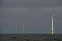
Turbines operate at South Fork Wind offshore wind farm off the coast of Block Island, R.I., Thursday, April 23, 2026. (AP Photo/Joshua A. Bickel)

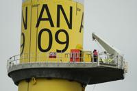
People work on a turbine at South Fork Wind offshore wind farm off the coast of Block Island, R.I., Thursday, April 23, 2026. (AP Photo/Joshua A. Bickel)

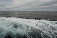
Turbines operate at South Fork Wind offshore wind farm off the coast of Block Island, R.I., Thursday, April 23, 2026. (AP Photo/Joshua A. Bickel)

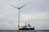
People work on a turbine near an Orsted boat at South Fork Wind offshore wind farm off the coast of Block Island, R.I., Thursday, April 23, 2026. (AP Photo/Joshua A. Bickel)

One of the most comprehensive studies ever of flood risk has determined that more than 17 million people in eight cities along the Atlantic and Gulf coasts are at the highest risk of being affected by flooding. Using machine learning, historic flood data and 16 factors representing hazards, exposure and vulnerability, the study published Wednesday in the journal Science Advances has come up with what is likely the most comprehensive model of coastal cities’ risk of flood damage. Researchers are alarmed by the findings, including that more than 4 million people are at risk in New York City, alone, and that 99% of people and buildings in New Orleans are vulnerable.
TOKYO (AP) — A powerful earthquake struck off the northern Japanese coast, and the Japan Meteorological Agency issued a tsunami alert in the region.


EQUIHEN BEACH, France (AP) — French authorities said that at least four people, two men and two women, died on Thursday as they were trying to…

AP
The beach in Marathon, east of Athens, Greece, is seen on Thursday, April 2, 2026, after heavy overnight storms caused extensive damage. (AP Photo/Thanassis Stavrakis)


U.S. President Donald Trump on Monday threatened to target Iran’s energy infrastructure, including the country's desalination plants. Such a m…