  • Facebook
  • Twitter
  • LinkedIn
  • YouTube
  • Instagram
  • Sign Up
  • Log In
  • Dashboard
  • Logout
    • My Account
    • Dashboard
    • Profile
    • Saved items
    • Logout
Home
  • About WBOC
  • Our Team
  • Programming
  • Contact Us
  • Careers
  • Internships
  • Policies
  • Report It
  • Get our newsletters
  • WBOC Apps
Unbridled Tradition: Pony Swim Special
News
  • Wicomico County
  • Worcester County
  • Somerset County
  • Dorchester County
  • Caroline County
  • Talbot County
  • Queen Annes County
  • Sussex County
  • Kent County
  • Accomack County
  • National News
  • International News
  • Latest Newscasts
  • Video Center
Weather
  • Forecast
  • Radar
  • Satellite
  • On The Waters
  • Weather Cameras
  • Closings
Delmarva Sports Network
Shows
  • DelmarvaLife
  • Outdoors Delmarva
  • Delmarva Home Show
Features
  • Obituaries
  • Heartbeat of Delmarva
  • Proud To Serve
  • Back to School
  • The M Report
  • Farming Our Future
  • Farm to Table Scholarship
  • Bless Our Children
  • Events: Shore Living Expo
Radio
  • 100.9% Classic Country WAAI
  • 107.1 The Duck
  • 102.5 WBOC FM
  • 93.5 The Beach
  • 107.7 BIG Classic Rock
  • 103.9 and 106.3 Coast Country
  • Watch Live
  • Apps
  • Contact Us
  • My Account
  • Sign Up
  • Log In
  • Dashboard
  • Logout
    • My Account
    • Dashboard
    • Profile
    • Saved items
    • Logout
  • Facebook
  • Twitter
  • LinkedIn
  • YouTube
  • Instagram
  • 80° Sunny
    • Salisbury, MD (21801)

      Today

      Rain early...then remaining cloudy with showers overnight. Low 66F. Winds SSW at 10 to 15 mph. Chance of rain 90%. Rainfall near a quarter of an inch..

      Tonight

      Rain early...then remaining cloudy with showers overnight. Low 66F. Winds SSW at 10 to 15 mph. Chance of rain 90%. Rainfall near a quarter of an inch.

      Updated: September 4, 2025 @ 5:52 pm

    • Full Forecast
site-logo
Watch Live

Newscast Schedule

View Programming Schedule
site-logo
  • 80°
  • Home
  • News
    • Wicomico County
    • Worcester County
    • Somerset County
    • Dorchester County
    • Caroline County
    • Talbot County
    • Queen Annes County
    • Sussex County
    • Kent County
    • Accomack County
    • National News
    • International News
    • Latest Newscasts
    • Video Center
    • Report It
  • Weather
    • Forecast
    • Radar
    • Satellite
    • On The Waters
    • Weather Cameras
    • Closings
  • Delmarva Sports Network
  • Shows
    • DelmarvaLife
    • Outdoors Delmarva
    • Delmarva Home Show
  • Features
    • Unbridled Tradition: Pony Swim Special
    • Obituaries
    • Heartbeat of Delmarva
    • Back to School
    • The M Report
    • Proud To Serve
    • Farming Our Future
    • Farm to Table Scholarship
    • Jefferson Awards
    • Delmarva Experts
    • Bless Our Children
    • Events: Shore Living Expo
  • Radio
    • 100.9% Classic Country WAAI
    • 107.1 The Duck
    • 93.5 The Beach
    • 107.7 BIG Classic Rock
    • 103.9 and 106.3 Coast Country
    • 102.5 WBOC FM
  • About Us
    • About WBOC
    • Our Team
    • Channel Finder
    • Apps
    • Contact Us
    • Get our newsletters
    • Careers
    • Internships
    • Policies
    • WBOC Solar Farm
Broadcast Schedule

On air schedule

Weather Alert

Weather Alert

...COASTAL FLOOD ADVISORY IN EFFECT FROM 10 PM THIS EVENING TO
5 AM EDT FRIDAY...

* WHAT...Up to one half foot of inundation above ground level
expected in low-lying areas near shorelines and tidal
waterways.

* WHERE...In Maryland, Dorchester, Wicomico and Somerset
Counties. In Virginia, Accomack County.

* WHEN...From 10 PM this evening to 5 AM EDT Friday.

* IMPACTS...Shallow flooding is expected in the most vulnerable
locations near the waterfront and shoreline resulting in a low
threat of property damage. Expect up to one foot of water
above ground level in low lying, vulnerable areas. Some roads
and low lying property including parking lots, parks and lawns
near the waterfront will experience shallow flooding.


PRECAUTIONARY/PREPAREDNESS ACTIONS...

If travel is required, allow extra time as some roads may be
closed. Do not drive around barricades or through water of
unknown depth. Take the necessary actions to protect flood-prone
property.

&&

Time of high total tides are approximate to the nearest hour.

CAMBRIDGE MD
MLLW CATEGORIES - MINOR 3.5 FT, MODERATE 4.0 FT, MAJOR 4.5 FT
MHHW CATEGORIES - MINOR 1.5 FT, MODERATE 2.0 FT, MAJOR 2.5 FT

TOTAL      TOTAL    DEPARTURE
DAY/TIME    TIDE       TIDE     FROM NORM   WAVES    FLOOD
FT MLLW    FT MHHW       FT       FT      IMPACT
--------  ---------  ---------  ---------  -------  --------
05/02 AM     3.4        1.4        1.1        1       NONE
05/02 PM     2.8        0.8        0.9        1       NONE
06/03 AM     3.4        1.4        1.1        1       NONE
06/03 PM     2.8        0.8        0.8        1       NONE
07/04 AM     3.0        1.0        0.6        1       NONE

BISHOPS HEAD MD
MLLW CATEGORIES - MINOR 3.2 FT, MODERATE 3.7 FT, MAJOR 4.2 FT
MHHW CATEGORIES - MINOR 1.1 FT, MODERATE 1.6 FT, MAJOR 2.1 FT

TOTAL      TOTAL    DEPARTURE
DAY/TIME    TIDE       TIDE     FROM NORM   WAVES    FLOOD
FT MLLW    FT MHHW       FT       FT      IMPACT
--------  ---------  ---------  ---------  -------  --------
05/12 AM     3.6        1.5        1.3        3      MINOR
05/12 PM     3.1        1.0        1.1        2       NONE
06/01 AM     3.7        1.6        1.3        3     MODERATE
06/01 PM     3.3        1.2        1.1        2      MINOR
07/01 AM     3.2        1.1        0.8        2      MINOR

CRISFIELD MD
MLLW CATEGORIES - MINOR 3.5 FT, MODERATE 4.0 FT, MAJOR 5.0 FT
MHHW CATEGORIES - MINOR 1.3 FT, MODERATE 1.8 FT, MAJOR 2.8 FT

TOTAL      TOTAL    DEPARTURE
DAY/TIME    TIDE       TIDE     FROM NORM   WAVES    FLOOD
FT MLLW    FT MHHW       FT       FT      IMPACT
--------  ---------  ---------  ---------  -------  --------
04/11 PM     3.6        1.4        1.5        1      MINOR
05/11 AM     2.8        0.6        1.2        1       NONE
06/12 AM     3.5        1.3        1.3        1      MINOR
06/12 PM     2.9        0.7        1.1        1       NONE
07/01 AM     3.1        0.9        0.9        1       NONE
07/01 PM     2.6        0.4        0.7        1       NONE

SAXIS VA
MLLW CATEGORIES - MINOR 4.5 FT, MODERATE 5.5 FT, MAJOR 6.5 FT
MHHW CATEGORIES - MINOR 2.0 FT, MODERATE 3.0 FT, MAJOR 4.0 FT

TOTAL      TOTAL    DEPARTURE
DAY/TIME    TIDE       TIDE     FROM NORM   WAVES    FLOOD
FT MLLW    FT MHHW       FT       FT      IMPACT
--------  ---------  ---------  ---------  -------  --------
04/10 PM     3.8        1.3        1.0       1-3      NONE
05/11 AM     3.6        1.1        1.2        2       NONE
05/11 PM     3.8        1.3        1.0        2       NONE
06/12 PM     3.4        0.9        0.8        2       NONE
07/12 AM     3.8        1.3        0.9        2       NONE
07/12 PM     3.0        0.5        0.2        2       NONE

NASSAWADOX CREEK AT BAYFORD VA
MLLW CATEGORIES - MINOR 3.0 FT, MODERATE 3.5 FT, MAJOR 4.5 FT
MHHW CATEGORIES - MINOR 1.0 FT, MODERATE 1.5 FT, MAJOR 2.5 FT

TOTAL      TOTAL    DEPARTURE
DAY/TIME    TIDE       TIDE     FROM NORM   WAVES    FLOOD
FT MLLW    FT MHHW       FT       FT      IMPACT
--------  ---------  ---------  ---------  -------  --------
04/09 PM     2.8        0.8        0.9       3-4      NONE
05/09 AM     2.5        0.5        0.9        2       NONE
05/10 PM     2.7        0.7        0.7        3       NONE
06/10 AM     2.5        0.5        0.7        2       NONE
06/11 PM     2.9        0.9        0.9        2       NONE
07/11 AM     2.6        0.6        0.7        3       NONE

CHINCOTEAGUE INLET VA
MLLW CATEGORIES - MINOR 4.5 FT, MODERATE 5.0 FT, MAJOR 6.0 FT
MHHW CATEGORIES - MINOR 1.7 FT, MODERATE 2.2 FT, MAJOR 3.2 FT

TOTAL      TOTAL    DEPARTURE
DAY/TIME    TIDE       TIDE     FROM NORM   WAVES    FLOOD
FT MLLW    FT MHHW       FT       FT      IMPACT
--------  ---------  ---------  ---------  -------  --------
04/06 PM     3.5        0.7        0.1        1       NONE
05/06 AM     2.7       -0.1       -0.2       1-3      NONE
05/07 PM     3.5        0.7        0.0       1-3      NONE
06/07 AM     2.9        0.1       -0.2        1       NONE
06/08 PM     3.6        0.8        0.0       2-3      NONE
07/08 AM     3.4        0.6        0.1        1       NONE

WACHAPREAGUE VA
MLLW CATEGORIES - MINOR 6.5 FT, MODERATE 7.5 FT, MAJOR 8.0 FT
MHHW CATEGORIES - MINOR 2.0 FT, MODERATE 3.0 FT, MAJOR 3.5 FT

TOTAL      TOTAL    DEPARTURE
DAY/TIME    TIDE       TIDE     FROM NORM   WAVES    FLOOD
FT MLLW    FT MHHW       FT       FT      IMPACT
--------  ---------  ---------  ---------  -------  --------
04/07 PM     5.4        0.9        0.8        1       NONE
05/07 AM     4.5        0.0        0.6        1       NONE
05/08 PM     5.2        0.7        0.5        1       NONE
06/08 AM     4.5        0.0        0.3        1       NONE
06/08 PM     5.2        0.7        0.4        1       NONE
07/09 AM     4.9        0.4        0.4        1       NONE

TANGIER ISLAND, VA
MLLW CATEGORIES - MINOR 3.2 FT, MODERATE 3.8 FT, MAJOR 4.2 FT
MHHW CATEGORIES - MINOR 1.4 FT, MODERATE 1.9 FT, MAJOR 2.4 FT

TOTAL      TOTAL    DEPARTURE
DAY/TIME    TIDE       TIDE     FROM NORM   WAVES    FLOOD
FT MLLW    FT MHHW       FT       FT      IMPACT
--------  ---------  ---------  ---------  -------  --------
04/10 PM     3.3        1.5        1.6        1      MINOR
05/11 AM     2.7        0.9        1.3        1       NONE
05/11 PM     3.1        1.2        1.3        1       NONE
06/11 AM     2.7        0.9        1.2        1       NONE
06/11 PM     3.1        1.2        1.4        1       NONE
07/12 PM     2.6        0.8        1.0        1       NONE

HARBORTON VA
MLLW CATEGORIES - MINOR 4.5 FT, MODERATE 5.5 FT, MAJOR 6.5 FT
MHHW CATEGORIES - MINOR 2.5 FT, MODERATE 3.5 FT, MAJOR 4.5 FT

TOTAL      TOTAL    DEPARTURE
DAY/TIME    TIDE       TIDE     FROM NORM   WAVES    FLOOD
FT MLLW    FT MHHW       FT       FT      IMPACT
--------  ---------  ---------  ---------  -------  --------
04/10 PM     3.3        1.3        1.2        1       NONE
05/10 AM     2.9        0.9        1.0        1       NONE
05/10 PM     3.0        1.0        0.9        1       NONE
06/11 AM     2.8        0.8        0.8        1       NONE
06/11 PM     3.3        1.3        1.0        1       NONE
07/12 PM     2.9        0.9        0.7        1       NONE

&&

Weather Alert

...SMALL CRAFT ADVISORY REMAINS IN EFFECT UNTIL 6 AM EDT FRIDAY...

* WHAT...South winds 10 to 20 kt with gusts up to 25 kt.

* WHERE...Chesapeake Bay from Drum Point MD to Smith Point VA,
Tidal Potomac from Cobb Island MD to Smith Point VA, Patuxent
River to Broomes Island MD and Tangier Sound and the inland
waters surrounding Bloodsworth Island.

* WHEN...Until 6 AM EDT Friday.

* IMPACTS...Conditions will be hazardous to small craft.

PRECAUTIONARY/PREPAREDNESS ACTIONS...

Inexperienced mariners, especially those operating smaller
vessels, should avoid navigating in hazardous conditions.

&&

eclipse


backtoschool


Advanced Search Close Search
From
To
Close Search
2:20
Heartbeat of Delmarva: Dover Diamonds
Latest News

Heartbeat of Delmarva: Dover Diamonds

  • Updated Jun 6, 2025

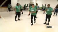
There's a class in Dover led by Denise Taylor. It teaches jump rope and hula hoops. It uses double dutch as therapy

2:32
Delmar Parents Angered by Old Law on Basketball Hoops
Latest News

Delmar Parents Angered by Old Law on Basketball Hoops

  • Updated Aug 17, 2022

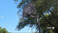
The town of Delmar has received complaints from drivers about kids playing basketball in the street. So the town posted a reminder of an ordna…

site-logo
  • Facebook
  • Twitter
  • LinkedIn
  • YouTube
  • Instagram

Sections

  • Latest Newscasts
  • Local News
  • Weather
  • Features
  • DelmarvaLife
  • Outdoors Delmarva
  • Delmarva Home Show
  • CoastTV
  • Telemundo Delmarva
  • Delmarva Sports Network
  • Video Center

Services

  • Search
  • Pay My Bill
  • Advertise With Us
  • Contact Us
  • Careers
  • Internships

Browser Compatibility

Your browser is out of date and potentially vulnerable to security risks.
We recommend switching to one of the following browsers:

Microsoft Edge Google Chrome Firefox
FCC Public File Applications & Related Materials EEO Public File Report FCC Closed Captioning Concerns Children's Programming Transparency Requirements for Group Health Plans
© Copyright 2025 WBOC TV 1729 N. Salisbury BLVD, Salisbury, MD  | Terms of Use  | Privacy Policy
Powered by BLOX Content Management System from BLOX Digital.