  • Facebook
  • Twitter
  • LinkedIn
  • YouTube
  • Instagram
  • Sign Up
  • Log In
  • Dashboard
  • Logout
    • My Account
    • Dashboard
    • Profile
    • Saved items
    • Logout
Home
  • About WBOC
  • Our Team
  • Programming
  • Contact Us
  • Careers
  • Internships
  • Policies
  • Report It
  • Get our newsletters
  • WBOC Apps
Unbridled Tradition: Pony Swim Special
News
  • Wicomico County
  • Worcester County
  • Somerset County
  • Dorchester County
  • Caroline County
  • Talbot County
  • Queen Annes County
  • Sussex County
  • Kent County
  • Accomack County
  • National News
  • International News
  • Latest Newscasts
  • Video Center
Weather
  • Forecast
  • Radar
  • Satellite
  • On The Waters
  • Weather Cameras
  • Closings
Delmarva Sports Network
Shows
  • DelmarvaLife
  • Outdoors Delmarva
  • Delmarva Home Show
Features
  • Obituaries
  • Heartbeat of Delmarva
  • Proud To Serve
  • Back to School
  • The M Report
  • Farming Our Future
  • Farm to Table Scholarship
  • Bless Our Children
  • Events: Shore Living Expo
Radio
  • 100.9% Classic Country WAAI
  • 107.1 The Duck
  • 102.5 WBOC FM
  • 93.5 The Beach
  • 107.7 BIG Classic Rock
  • 103.9 and 106.3 Coast Country
  • Watch Live
  • Apps
  • Contact Us
  • My Account
  • Sign Up
  • Log In
  • Dashboard
  • Logout
    • My Account
    • Dashboard
    • Profile
    • Saved items
    • Logout
  • Facebook
  • Twitter
  • LinkedIn
  • YouTube
  • Instagram
  • 69° Mostly Cloudy
    • Salisbury, MD (21801)

      Today

      Increasing clouds with showers arriving overnight. Low 53F. Winds WSW at 15 to 25 mph. Chance of rain 50%. Higher wind gusts possible..

      Tonight

      Increasing clouds with showers arriving overnight. Low 53F. Winds WSW at 15 to 25 mph. Chance of rain 50%. Higher wind gusts possible.

      Updated: October 19, 2025 @ 10:47 pm

    • Full Forecast
site-logo
Watch Live

Newscast Schedule

View Programming Schedule
site-logo
  • 69°
  • Home
  • News
    • Wicomico County
    • Worcester County
    • Somerset County
    • Dorchester County
    • Caroline County
    • Talbot County
    • Queen Annes County
    • Sussex County
    • Kent County
    • Accomack County
    • National News
    • International News
    • Latest Newscasts
    • Video Center
    • Report It
  • Weather
    • Forecast
    • Radar
    • Satellite
    • On The Waters
    • Weather Cameras
    • Closings
  • Delmarva Sports Network
  • Shows
    • DelmarvaLife
    • Outdoors Delmarva
    • Delmarva Home Show
  • Features
    • Unbridled Tradition: Pony Swim Special
    • Obituaries
    • Heartbeat of Delmarva
    • Back to School
    • The M Report
    • Proud To Serve
    • Farming Our Future
    • Farm to Table Scholarship
    • Jefferson Awards
    • Delmarva Experts
    • Bless Our Children
    • Events: Shore Living Expo
  • Radio
    • 100.9% Classic Country WAAI
    • 107.1 The Duck
    • 93.5 The Beach
    • 107.7 BIG Classic Rock
    • 103.9 and 106.3 Coast Country
    • 102.5 WBOC FM
  • About Us
    • About WBOC
    • Our Team
    • Channel Finder
    • Apps
    • Contact Us
    • Get our newsletters
    • Careers
    • Internships
    • Policies
    • WBOC Solar Farm
  • Report It
Broadcast Schedule

On air schedule

Weather Alert

Weather Alert

The National Weather Service in Sterling Virginia has issued a

* Special Marine Warning for...
Chesapeake Bay from Drum Point MD to Smith Point VA...
Chesapeake Bay from North Beach to Drum Point MD...
Patuxent River to Broomes Island MD...
Tangier Sound and the inland waters surrounding Bloodsworth
Island...

* Until 1145 PM EDT.

* At 1044 PM EDT, showers were located along a line extending from 8
nm west of Broomes Island to Coltons Point, moving northeast at 30
knots.

HAZARD...Wind gusts 34 knots or greater.

SOURCE...Radar indicated.

IMPACT...Boaters in small craft could be thrown overboard by
suddenly higher winds and waves capsizing their vessel.

* Locations impacted include...
Cuckold Creek, Greenwell State Park, Town Creek, Hooper Island
Light, Saint Leonard Creek, Drum Point, Calvert Cliffs, and
Solomons Island.

PRECAUTIONARY/PREPAREDNESS ACTIONS...

Move to safe harbor until hazardous weather passes.

&&


HAIL...0.00IN;
WIND...>34KTS

Weather Alert

...COASTAL FLOOD WARNING REMAINS IN EFFECT UNTIL 5 AM EDT
MONDAY...

* WHAT...Up to one to two feet of inundation above ground level
in low- lying areas near shorelines and tidal waterways.

* WHERE...Dorchester and Wicomico Counties.

* WHEN...Until 5 AM EDT Monday.

* IMPACTS...Widespread flooding of vulnerable areas will result
in an elevated threat of property damage to homes and
businesses near the waterfront and shoreline. Water will be 1
to 2 feet above ground level in some areas resulting in a
sufficient depth to close numerous roads and threaten homes
and businesses. Flooding will extend inland from the
waterfront along tidal rivers and bays resulting in some road
closures and flooding of vehicles.

PRECAUTIONARY/PREPAREDNESS ACTIONS...

Take the necessary actions to protect flood-prone property. If
travel is required, do not drive around barricades or through
water of unknown depth.

&&

Time of high total tides are approximate to the nearest hour.

CAMBRIDGE MD
MLLW CATEGORIES - MINOR 3.5 FT, MODERATE 4.0 FT, MAJOR 4.5 FT
MHHW CATEGORIES - MINOR 1.5 FT, MODERATE 2.0 FT, MAJOR 2.5 FT

TOTAL      TOTAL    DEPARTURE
DAY/TIME    TIDE       TIDE     FROM NORM   WAVES    FLOOD
FT MLLW    FT MHHW       FT       FT      IMPACT
--------  ---------  ---------  ---------  -------  --------
20/03 AM     4.0        2.0        2.1        2     MODERATE
20/04 PM     3.2        1.2        1.0       1-2      NONE
21/04 AM     2.7        0.7        0.7        1       NONE
21/05 PM     2.9        0.9        0.7        1       NONE
22/05 AM     2.8        0.8        0.9        1       NONE
22/05 PM     2.8        0.8        0.7        1       NONE

BISHOPS HEAD MD
MLLW CATEGORIES - MINOR 3.2 FT, MODERATE 3.7 FT, MAJOR 4.2 FT
MHHW CATEGORIES - MINOR 1.1 FT, MODERATE 1.6 FT, MAJOR 2.1 FT

TOTAL      TOTAL    DEPARTURE
DAY/TIME    TIDE       TIDE     FROM NORM   WAVES    FLOOD
FT MLLW    FT MHHW       FT       FT      IMPACT
--------  ---------  ---------  ---------  -------  --------
20/01 AM     3.9        1.8        1.8        3     MODERATE
20/01 PM     3.2        1.1        0.9        2      MINOR
21/02 AM     2.7        0.6        0.7        1       NONE
21/02 PM     3.1        1.0        0.8        2       NONE
22/02 AM     2.9        0.8        1.0       1-2      NONE
22/02 PM     2.7        0.6        0.6        1       NONE

&&

Weather Alert

...SMALL CRAFT ADVISORY REMAINS IN EFFECT UNTIL 6 PM EDT MONDAY...

* WHAT...South winds becoming west, 15 to 25 kt with gusts up to
30 kt and waves 2 to 4 ft.

* WHERE...Tidal Potomac River from Key Bridge to Smith Point VA,
and Chesapeake Bay and adjoining estuaries north of Smith
Point VA.

* WHEN...Until 6 PM EDT Monday.

* IMPACTS...Conditions will be hazardous to small craft.

PRECAUTIONARY/PREPAREDNESS ACTIONS...

Inexperienced mariners, especially those operating smaller
vessels, should avoid navigating in hazardous conditions.

&&

eclipse


Advanced Search Close Search
From
To
Close Search
2:45
Fresh Delaware Faces City Bans Blocking Recreational Cannabis Sales
Latest News

Fresh Delaware Faces City Bans Blocking Recreational Cannabis Sales

  • Tiffani Amber
  • Updated Aug 8, 2025

Although it has been one week since Delaware's adult-use recreational cannabis market officially opened, Fresh Delaware says two of its three locations have been unable to participate due to city bans on recreational marijuana sales.

2:25+3
Seaford City Leaders Outline the Future of the Nylon Capital Shopping Center
Latest News

Seaford City Leaders Outline the Future of the Nylon Capital Shopping Center

  • Maegan Summers
  • Updated Dec 12, 2024

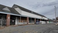
Seaford city leaders revealed a new roadmap for the Nylon Capital Shopping Center, giving a timeline for future updates at the site. 

site-logo
  • Facebook
  • Twitter
  • LinkedIn
  • YouTube
  • Instagram

Sections

  • Latest Newscasts
  • Local News
  • Weather
  • Features
  • DelmarvaLife
  • Outdoors Delmarva
  • Delmarva Home Show
  • CoastTV
  • Telemundo Delmarva
  • Delmarva Sports Network
  • Video Center

Services

  • Search
  • Pay My Bill
  • Advertise With Us
  • Contact Us
  • Careers
  • Internships

Browser Compatibility

Your browser is out of date and potentially vulnerable to security risks.
We recommend switching to one of the following browsers:

Microsoft Edge Google Chrome Firefox
FCC Public File Applications & Related Materials EEO Public File Report FCC Closed Captioning Concerns Children's Programming Transparency Requirements for Group Health Plans
© Copyright 2025 WBOC TV 1729 N. Salisbury BLVD, Salisbury, MD  | Terms of Use  | Privacy Policy
Powered by BLOX Content Management System from BLOX Digital.