  • Facebook
  • Twitter
  • LinkedIn
  • YouTube
  • Instagram
  • Sign Up
  • Log In
  • Dashboard
  • Logout
    • My Account
    • Dashboard
    • Profile
    • Saved items
    • Logout
Home
  • About WBOC
  • Our Team
  • Programming
  • Contact Us
  • Careers
  • Internships
  • Policies
  • Report It
  • Get our newsletters
  • WBOC Apps
Unbridled Tradition: Pony Swim Special
News
  • Wicomico County
  • Worcester County
  • Somerset County
  • Dorchester County
  • Caroline County
  • Talbot County
  • Queen Annes County
  • Sussex County
  • Kent County
  • Accomack County
  • National News
  • International News
  • Latest Newscasts
  • Video Center
Weather
  • Forecast
  • Radar
  • Satellite
  • On The Waters
  • Weather Cameras
  • Closings
Delmarva Sports Network
Shows
  • DelmarvaLife
  • Outdoors Delmarva
  • Delmarva Home Show
Features
  • Obituaries
  • Heartbeat of Delmarva
  • Proud To Serve
  • Back to School
  • The M Report
  • Farming Our Future
  • Farm to Table Scholarship
  • Bless Our Children
  • Events: Shore Living Expo
Radio
  • 100.9% Classic Country WAAI
  • 107.1 The Duck
  • 102.5 WBOC FM
  • 93.5 The Beach
  • 107.7 BIG Classic Rock
  • 103.9 and 106.3 Coast Country
  • Watch Live
  • Apps
  • Contact Us
  • My Account
  • Sign Up
  • Log In
  • Dashboard
  • Logout
    • My Account
    • Dashboard
    • Profile
    • Saved items
    • Logout
  • Facebook
  • Twitter
  • LinkedIn
  • YouTube
  • Instagram
  • 57°
    • Salisbury, MD (21801)

      Today

      Considerable cloudiness with occasional rain showers. Low 56F. Winds N at 15 to 25 mph. Chance of rain 60%. Higher wind gusts possible..

      Tonight

      Considerable cloudiness with occasional rain showers. Low 56F. Winds N at 15 to 25 mph. Chance of rain 60%. Higher wind gusts possible.

      Updated: October 12, 2025 @ 6:42 pm

    • Full Forecast
site-logo
Watch Live

Newscast Schedule

View Programming Schedule
site-logo
  • 57°
  • Home
  • News
    • Wicomico County
    • Worcester County
    • Somerset County
    • Dorchester County
    • Caroline County
    • Talbot County
    • Queen Annes County
    • Sussex County
    • Kent County
    • Accomack County
    • National News
    • International News
    • Latest Newscasts
    • Video Center
    • Report It
  • Weather
    • Forecast
    • Radar
    • Satellite
    • On The Waters
    • Weather Cameras
    • Closings
  • Delmarva Sports Network
  • Shows
    • DelmarvaLife
    • Outdoors Delmarva
    • Delmarva Home Show
  • Features
    • Unbridled Tradition: Pony Swim Special
    • Obituaries
    • Heartbeat of Delmarva
    • Back to School
    • The M Report
    • Proud To Serve
    • Farming Our Future
    • Farm to Table Scholarship
    • Jefferson Awards
    • Delmarva Experts
    • Bless Our Children
    • Events: Shore Living Expo
  • Radio
    • 100.9% Classic Country WAAI
    • 107.1 The Duck
    • 93.5 The Beach
    • 107.7 BIG Classic Rock
    • 103.9 and 106.3 Coast Country
    • 102.5 WBOC FM
  • About Us
    • About WBOC
    • Our Team
    • Channel Finder
    • Apps
    • Contact Us
    • Get our newsletters
    • Careers
    • Internships
    • Policies
    • WBOC Solar Farm
Broadcast Schedule

On air schedule

Weather Alert

Weather Alert

...COASTAL FLOOD WARNING IN EFFECT UNTIL 11 PM EDT THIS EVENING...

* WHAT...One to two feet of inundation above ground level in low-
lying areas near shorelines and tidal waterways.

* WHERE...Southern Dorchester, Wicomico and Somerset Counties.

* WHEN...Until 11 PM EDT this evening.

* IMPACTS...Widespread flooding of vulnerable areas will result in
an elevated threat of property damage to homes and businesses
near the waterfront and shoreline. Water will be 1 to 2 feet
above ground level in some areas resulting in a sufficient depth
to close roads and threaten homes and businesses. Flooding will
extend inland from the waterfront along tidal rivers and bays
resulting in some road closures and flooding of vehicles.

PRECAUTIONARY/PREPAREDNESS ACTIONS...

Take the necessary actions to protect flood-prone property. If
travel is required, do not drive around barricades or through
water of unknown depth.

&&

Time of high total tides are approximate to the nearest hour.

CAMBRIDGE MD
MLLW CATEGORIES - MINOR 3.5 FT, MODERATE 4.0 FT, MAJOR 4.5 FT
MHHW CATEGORIES - MINOR 1.5 FT, MODERATE 2.0 FT, MAJOR 2.5 FT

TOTAL      TOTAL    DEPARTURE
DAY/TIME    TIDE       TIDE     FROM NORM   WAVES    FLOOD
FT MLLW    FT MHHW       FT       FT      IMPACT
--------  ---------  ---------  ---------  -------  --------
12/09 PM     3.5        1.5        1.3       1-2     MINOR
13/09 AM     3.3        1.3        1.5        1       NONE
13/10 PM     3.2        1.2        1.1        1       NONE
14/10 AM     2.5        0.5        0.7        1       NONE
15/12 AM     2.7        0.7        0.6        2       NONE
15/11 AM     2.8        0.8        1.0        2       NONE

BISHOPS HEAD MD
MLLW CATEGORIES - MINOR 3.2 FT, MODERATE 3.7 FT, MAJOR 4.2 FT
MHHW CATEGORIES - MINOR 1.1 FT, MODERATE 1.6 FT, MAJOR 2.1 FT

TOTAL      TOTAL    DEPARTURE
DAY/TIME    TIDE       TIDE     FROM NORM   WAVES    FLOOD
FT MLLW    FT MHHW       FT       FT      IMPACT
--------  ---------  ---------  ---------  -------  --------
12/06 PM     3.8        1.7        1.5        2     MODERATE
13/07 AM     3.5        1.4        1.5        2      MINOR
13/07 PM     3.5        1.4        1.3        1      MINOR
14/08 AM     2.9        0.8        0.9        1       NONE
14/09 PM     3.1        1.0        0.9        2       NONE
15/09 AM     3.0        0.9        1.0        2       NONE

CRISFIELD MD
MLLW CATEGORIES - MINOR 3.5 FT, MODERATE 4.0 FT, MAJOR 5.0 FT
MHHW CATEGORIES - MINOR 1.3 FT, MODERATE 1.8 FT, MAJOR 2.8 FT

TOTAL      TOTAL    DEPARTURE
DAY/TIME    TIDE       TIDE     FROM NORM   WAVES    FLOOD
FT MLLW    FT MHHW       FT       FT      IMPACT
--------  ---------  ---------  ---------  -------  --------
12/05 PM     4.0        1.8        1.8        1     MODERATE
13/06 AM     3.5        1.3        2.0        1      MINOR
13/06 PM     3.9        1.7        1.8        1      MINOR
14/06 AM     2.7        0.5        1.4        1       NONE
14/08 PM     3.2        1.0        1.2        1       NONE
15/08 AM     2.8        0.6        1.3        1       NONE

&&

Weather Alert

...GALE WARNING REMAINS IN EFFECT UNTIL 8 AM EDT MONDAY...

* WHAT...North winds 20 to 30 kt with gusts up to 40 kt and
waves 3 to 6 ft.

* WHERE...Chesapeake Bay from Sandy Point MD to Smith Point VA,
Tidal Potomac from Cobb Island MD to Smith Point VA, Eastern
Bay, Choptank River to Cambridge MD and the Little Choptank
River, Patuxent River to Broomes Island MD, and Tangier Sound
and the inland waters surrounding Bloodsworth Island.

* WHEN...Until 8 AM EDT Monday.

* IMPACTS...Strong winds will cause hazardous waves which could
capsize or damage vessels.

PRECAUTIONARY/PREPAREDNESS ACTIONS...

Mariners should alter plans to avoid these hazardous conditions.
Remain in port, seek safe harbor, alter course, and/or secure the
vessel for hazardous conditions.

&&

eclipse


Closings

Click here to view closings and delays

Advanced Search Close Search
From
To
Close Search
+2
Ocean City Police Welcome Newest Horse to Mounted Unit
Latest News

Ocean City Police Welcome Newest Horse to Mounted Unit

  • Sean Curtis
  • Updated Apr 23, 2024

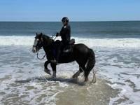
The Ocean City Police Department has a new equine addition to their Mounted Unit, Buckshot.

site-logo
  • Facebook
  • Twitter
  • LinkedIn
  • YouTube
  • Instagram

Sections

  • Latest Newscasts
  • Local News
  • Weather
  • Features
  • DelmarvaLife
  • Outdoors Delmarva
  • Delmarva Home Show
  • CoastTV
  • Telemundo Delmarva
  • Delmarva Sports Network
  • Video Center

Services

  • Search
  • Pay My Bill
  • Advertise With Us
  • Contact Us
  • Careers
  • Internships

Browser Compatibility

Your browser is out of date and potentially vulnerable to security risks.
We recommend switching to one of the following browsers:

Microsoft Edge Google Chrome Firefox
FCC Public File Applications & Related Materials EEO Public File Report FCC Closed Captioning Concerns Children's Programming Transparency Requirements for Group Health Plans
© Copyright 2025 WBOC TV 1729 N. Salisbury BLVD, Salisbury, MD  | Terms of Use  | Privacy Policy
Powered by BLOX Content Management System from BLOX Digital.