


St. Paul's by-the-Sea Episcopal Church has officially filed a lawsuit alleging the Ocean City mayor Rick Meehan and the city council are viola…
From
To


Ocean City officials issued citations Monday to St. Paul’s by-the-Sea Episcopal Church after the church continued operating an overnight shelt…


A flying boat emergency landed in Assawoman Bay in Ocean City this afternoon after one of its stabilizing floats came off, according to the Oc…


Rainy weather and rougher surf changed Memorial Day weekend plans for visitors in Ocean City, leaving stretches of the beach and inlet parking…


Ocean City is ushering in the unofficial start of summer with several changes on the Boardwalk and beach, even as cloudy skies and rain threat…

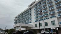
A dreary weather forecast heading into Memorial Day weekend is already taking a toll on hotel bookings in Ocean City. Some hospitality leaders…


A small plane that made an emergency landing on the beach near 94th Street in Ocean City has been removed, one day after first responders were…


Surfer Brendan Oster says he was paddling on his surfboard when he says a shark clamped down on his hand.


Ocean City rescue swimmers trained with Maryland Natural Resources Police near the inlet and jetty rocks Monday morning as first responders pr…


Opponents of a proposed Globalinx cable landing station near Ocean City Municipal Airport say they are continuing to push for answers after a …