

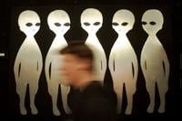
WASHINGTON (AP) — One was a rotating disc that sent out beams of light. Another was a shining red orb of a hue the observer had never seen bef…
From
To


AP
NEW YORK (AP) — If the New York Knicks win it all this year, just remember that Evan Pfeufer called it six years ago, and has the receipts to …

AP
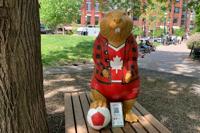
TORONTO (AP) — Berczy Park is home to a much-loved fountain featuring canine sculptures that shoot water out of their mouths. But now, there's…

AP
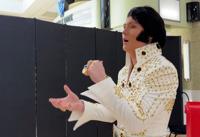
TUPELO, Miss. (AP) — Nearly 50 years after Elvis Presley 's death, a gaggle of exuberant young boys and teens shook up his hometown, intent on…

AP
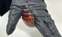
WELLINGTON, New Zealand (AP) — More than 100,000 live cockroaches illegal to keep in Australia were confiscated from a single breeder in the c…

AP
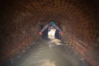
A former urban explorer says the most unpleasant part of exploring New York City’s sewer system was the cockroaches, not the rats, smells or ever-present dangers. Steven Duncan reflected this week on his years documenting the subterranean networks running under New York and other world cities after groups of people were captured on surveillance videos popping in and out of sewers in Brooklyn and Queens in recent days. Duncan believes the groups were likely traversing the large, 19th century sewer mains that run underneath parts of the city. Officials stress it’s not just illegal to enter the sewers but also extremely dangerous.


AP
CAPE CANAVERAL, Fla. (AP) — The group leading the charge in the search for extraterrestrial life has given the all clear: An interstellar come…


DHAKA, Bangladesh (AP) — With his shock of golden hair and trim 700-kilogram (1,500-pound) build, Donald Trump has been drawing crowds from ac…
NEW YORK (AP) — Mole people? Crocodile catchers? Mario brothers? A series of bizarre sightings of people popping in and out of New York City’s…

AP
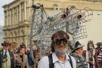
ŌAMARU, New Zealand (AP) — The woman in the pink frock coat announced herself as steam curled from a strange brass contraption on her back.