


Music, food and cultural performances filled George C. Wright Jr. Municipal Park on Friday as many gathered for the fourth annual Juneteenth E…
From
To


San Domingo Creek Park is going to be transformed into a waterfront commons area, thanks to grand funding from the state of Maryland.

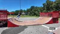
The Town of Smyrna recently announced plans to close the skatepark at George Wright Park, citing safety concerns tied to deteriorating equipme…


WBOC is proud to serve Holts Landing State Park, and all of Sussex County.


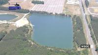
A future public park in Wicomico County is moving one step closer to reality after county leaders approved a proposal tied to the Connelly Mil…


Maryland officials have announced that the Pocomoke River State Park’s historic swimming pool will be closed to the public this summer due to …


Small divots in the pavement at the Salisbury Skate Park are expected to be repaired within the next couple of weeks. This comes after city of…


Surfer Brendan Oster says he was paddling on his surfboard when he says a shark clamped down on his hand.


A new industrial development is taking shape just outside the Dover Air Force Base, as developers look to bring more business growth and jobs …