  • Facebook
  • Twitter
  • LinkedIn
  • YouTube
  • Instagram
  • Sign Up
  • Log In
  • Dashboard
  • Logout
    • My Account
    • Dashboard
    • Profile
    • Saved items
    • Logout
Home
  • About WBOC
  • Our Team
  • Programming
  • Contact Us
  • Careers
  • Internships
  • Policies
  • Report It
  • Get our newsletters
  • WBOC Apps
News
  • Wicomico County
  • Worcester County
  • Somerset County
  • Dorchester County
  • Caroline County
  • Talbot County
  • Queen Annes County
  • Sussex County
  • Kent County
  • Accomack County
  • National News
  • International News
  • Latest Newscasts
  • Video Center
Weather
  • Forecast
  • Radar
  • Satellite
  • On The Waters
  • Weather Cameras
  • Closings
Delmarva Sports Network
Shows
  • DelmarvaLife
  • Outdoors Delmarva
  • Delmarva Home Show
Features
  • Travels With Charlie
  • Bless Our Children
  • Proud To Serve
  • The M Report
  • Heartbeat of Delmarva
  • Honoring Delmarva Farmers
  • Farm to Table Scholarship
  • Obituaries
  • Events: DSN Outdoors Expo
Radio
  • 100.9% Classic Country WAAI
  • 107.1 The Duck
  • 102.5 WBOC FM
  • 93.5 The Beach
  • 107.7 BIG Classic Rock
  • 103.9 and 106.3 Coast Country
  • Watch Live
  • Apps
  • Contact Us
  • My Account
  • Sign Up
  • Log In
  • Dashboard
  • Logout
    • My Account
    • Dashboard
    • Profile
    • Saved items
    • Logout
  • Facebook
  • Twitter
  • LinkedIn
  • YouTube
  • Instagram
  • 60° Light Rain
    • Salisbury, MD (21801)

      Today

      Thunderstorms this evening, then skies turning partly cloudy after midnight. Low 51F. Winds W at 5 to 10 mph. Chance of rain 90%..

      Tonight

      Thunderstorms this evening, then skies turning partly cloudy after midnight. Low 51F. Winds W at 5 to 10 mph. Chance of rain 90%.

      Updated: May 22, 2025 @ 7:35 pm

    • Full Forecast
site-logo
Watch Live

Newscast Schedule

View Programming Schedule
site-logo
  • 60°
  • Home
  • News
    • Local News
    • National News
    • International News
    • Latest Newscasts
    • Video Center
    • Wicomico County
    • Worcester County
    • Somerset County
    • Dorchester County
    • Caroline County
    • Talbot County
    • Queen Annes County
    • Sussex County
    • Kent County
    • Accomack County
    • Report It
  • Weather
    • Forecast
    • Radar
    • Satellite
    • On The Waters
    • Weather Cameras
    • Closings
  • Delmarva Sports Network
  • Shows
    • DelmarvaLife
    • Outdoors Delmarva
    • Delmarva Home Show
  • Features
    • Heartbeat of Delmarva
    • The M Report
    • Proud To Serve
    • Travels With Charlie
    • Honoring Delmarva Farmers
    • Farm to Table Scholarship
    • Jefferson Awards
    • Obituaries
    • Delmarva Experts
    • Bless Our Children
    • Events: DSN Outdoors Expo
  • Radio
    • 100.9% Classic Country WAAI
    • 107.1 The Duck
    • 93.5 The Beach
    • 107.7 BIG Classic Rock
    • 103.9 and 106.3 Coast Country
    • 102.5 WBOC FM
  • About Us
    • About WBOC
    • Our Team
    • Channel Finder
    • Apps
    • Contact Us
    • Get our newsletters
    • Careers
    • Internships
    • Policies
    • WBOC Solar Farm
Broadcast Schedule

On air schedule

Weather Alert

Weather Alert

...A SPECIAL MARINE WARNING REMAINS IN EFFECT UNTIL 815 PM EDT...

For the following areas...
Tangier Sound and the inland waters surrounding Bloodsworth Island...

At 717 PM EDT, the first storm near Hoopers Island has weakened, and
a new severe thunderstorm was located over Deal Island, moving east
at 25 knots.

HAZARD...Wind gusts 34 knots or greater and large hail.

SOURCE...Radar indicated.

IMPACT...Boaters in small craft could be thrown overboard by
suddenly higher winds and waves capsizing their vessel.
Hail may damage your vessel.

Locations impacted include...
Nanticoke River Mouth, Fishing Bay, and Deal Island.

PRECAUTIONARY/PREPAREDNESS ACTIONS...

Move to safe harbor until hazardous weather passes.

&&


HAIL...>.75IN;
WIND...>34KTS

Weather Alert

...SMALL CRAFT ADVISORY REMAINS IN EFFECT UNTIL 6 PM EDT FRIDAY...

* WHAT...Northwest winds 10 to 15 kt with gusts up to 20 kt.

* WHERE...Chesapeake Bay from North Beach MD to Smith Point VA,
Tidal Potomac from Cobb Island MD to Smith Point VA, Choptank
River to Cambridge MD and the Little Choptank River, and
Tangier Sound and the inland waters surrounding Bloodsworth
Island.

* WHEN...Until 6 PM EDT Friday.

* IMPACTS...Conditions will be hazardous to small craft.

PRECAUTIONARY/PREPAREDNESS ACTIONS...

Inexperienced mariners, especially those operating smaller
vessels, should avoid navigating in hazardous conditions.

&&

Weather Alert

...COASTAL FLOOD STATEMENT IN EFFECT FROM 8 PM THIS EVENING TO
2 AM EDT FRIDAY...

* WHAT...Up to one half foot of inundation above ground level
expected in low-lying areas near shorelines and tidal
waterways.

* WHERE...Dorchester, Wicomico and Somerset Counties.

* WHEN...From 8 PM this evening to 2 AM EDT Friday.

* IMPACTS...Shallow flooding is possible in the most vulnerable
locations near the waterfront and shoreline.

PRECAUTIONARY/PREPAREDNESS ACTIONS...

Do not drive through flooded roadways.

&&

Time of high total tides are approximate to the nearest hour.

CAMBRIDGE MD
MLLW CATEGORIES - MINOR 3.5 FT, MODERATE 4.0 FT, MAJOR 4.5 FT
MHHW CATEGORIES - MINOR 1.5 FT, MODERATE 2.0 FT, MAJOR 2.5 FT

TOTAL      TOTAL    DEPARTURE
DAY/TIME    TIDE       TIDE     FROM NORM   WAVES    FLOOD
FT MLLW    FT MHHW       FT       FT      IMPACT
--------  ---------  ---------  ---------  -------  --------
23/12 AM     3.3        1.3        1.3        1       NONE
23/01 PM     3.0        1.0        1.2        1       NONE
24/02 AM     3.1        1.1        0.9        1       NONE
24/02 PM     2.4        0.4        0.6        1       NONE
25/03 AM     2.6        0.6        0.2        1       NONE

BISHOPS HEAD MD
MLLW CATEGORIES - MINOR 3.2 FT, MODERATE 3.7 FT, MAJOR 4.2 FT
MHHW CATEGORIES - MINOR 1.1 FT, MODERATE 1.6 FT, MAJOR 2.1 FT

TOTAL      TOTAL    DEPARTURE
DAY/TIME    TIDE       TIDE     FROM NORM   WAVES    FLOOD
FT MLLW    FT MHHW       FT       FT      IMPACT
--------  ---------  ---------  ---------  -------  --------
22/10 PM     3.4        1.3        1.2        2      MINOR
23/10 AM     3.2        1.1        1.2        2      MINOR
23/11 PM     3.2        1.1        0.8        2      MINOR
24/11 AM     2.5        0.4        0.5        2       NONE
25/12 AM     2.7        0.6        0.2        1       NONE
25/12 PM     2.1        0.0        0.1        1       NONE

CRISFIELD MD
MLLW CATEGORIES - MINOR 3.5 FT, MODERATE 4.0 FT, MAJOR 5.0 FT
MHHW CATEGORIES - MINOR 1.3 FT, MODERATE 1.8 FT, MAJOR 2.8 FT

TOTAL      TOTAL    DEPARTURE
DAY/TIME    TIDE       TIDE     FROM NORM   WAVES    FLOOD
FT MLLW    FT MHHW       FT       FT      IMPACT
--------  ---------  ---------  ---------  -------  --------
22/10 PM     3.3        1.1        1.3        1       NONE
23/10 AM     3.2        1.0        1.3        1       NONE
23/11 PM     3.2        1.0        1.0        1       NONE
24/11 AM     2.4        0.2        0.6        1       NONE
24/11 PM     2.6        0.4        0.3        1       NONE
25/11 AM     1.9       -0.3        0.2        1       NONE

&&

Advanced Search Close Search
From
To
Close Search
1:48
Small Farmers in Somerset County Feel the Impact of Severely Dry Conditions
Latest News

Small Farmers in Somerset County Feel the Impact of Severely Dry Conditions

  • Updated Nov 1, 2024

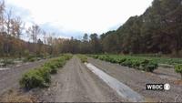
Floyd Pugh of C.P. Farm in Westover, Md., says he does not have a working irrigation system, which is why a fourth of his planted seeds did no…

Travels With Charlie: Seeds Go Pop in the Night
Delmarvalife

Travels With Charlie: Seeds Go Pop in the Night

  • By Marlon Wallace
  • Updated Jun 13, 2023
Travels With Charlie: Seeds Go Pop in the Night
Delmarvalife

Travels With Charlie: Seeds Go Pop in the Night

  • By Charlie Paparella
  • Updated Jun 13, 2023

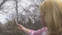
  WBOC’s Charles Paparellas asks Ginny Rosenkranz about a mysterious sound in the woods at night.

site-logo
  • Facebook
  • Twitter
  • LinkedIn
  • YouTube
  • Instagram

Sections

  • Latest Newscasts
  • Local News
  • Weather
  • Features
  • DelmarvaLife
  • Outdoors Delmarva
  • Delmarva Home Show
  • CoastTV
  • Telemundo Delmarva
  • Delmarva Sports Network
  • Video Center

Services

  • Search
  • Pay My Bill
  • Advertise With Us
  • Contact Us
  • Careers
  • Internships

Browser Compatibility

Your browser is out of date and potentially vulnerable to security risks.
We recommend switching to one of the following browsers:

Microsoft Edge Google Chrome Firefox
FCC Public File Applications & Related Materials EEO Public File Report FCC Closed Captioning Concerns Children's Programming Transparency Requirements for Group Health Plans
© Copyright 2025 WBOC TV 1729 N. Salisbury BLVD, Salisbury, MD  | Terms of Use  | Privacy Policy
Powered by BLOX Content Management System from BLOX Digital.