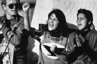
  • Facebook
  • Twitter
  • LinkedIn
  • YouTube
  • Instagram
  • Sign Up
  • Log In
  • Dashboard
  • Logout
    • My Account
    • Dashboard
    • Profile
    • Saved items
    • Logout
Home
  • About WBOC
  • Our Team
  • Programming
  • Contact Us
  • Careers
  • Internships
  • Policies
  • Report It
  • Get our newsletters
  • WBOC Apps
News
  • Wicomico County
  • Worcester County
  • Somerset County
  • Dorchester County
  • Caroline County
  • Talbot County
  • Queen Annes County
  • Sussex County
  • Kent County
  • Accomack County
  • National News
  • International News
  • Latest Newscasts
  • Video Center
Weather
  • Forecast
  • Radar
  • Satellite
  • On The Waters
  • Weather Cameras
  • Closings
Delmarva Sports Network
Shows
  • DelmarvaLife
  • Outdoors Delmarva
  • Delmarva Home Show
Features
  • Bless Our Children
  • Holiday House
  • Obituaries
  • Heartbeat of Delmarva
  • Proud To Serve
  • The M Report
  • Farming Our Future
  • Farm to Table Scholarship
  • Events: Job Fair
Radio
  • WDEL
  • 100.9% Classic Country
  • 107.1 The Duck
  • 102.5 WBOC FM
  • 93.5 The Beach
  • 107.7 BIG Classic Rock
  • 103.9 & 106.3 Coast Country
  • 93.7 WSTW
  • WXCY 103.7 & 96.9
  • WCEI 96.7
  • 94.3 Dockside
  • Watch Live
  • Apps
  • Contact Us
  • My Account
  • Sign Up
  • Log In
  • Dashboard
  • Logout
    • My Account
    • Dashboard
    • Profile
    • Saved items
    • Logout
  • Facebook
  • Twitter
  • LinkedIn
  • YouTube
  • Instagram
  • 21° Mostly Cloudy
    • Salisbury, MD (21801)

      Today

      Cloudy. A few flurries or snow showers possible. Low 14F. Winds N at 15 to 25 mph..

      Tonight

      Cloudy. A few flurries or snow showers possible. Low 14F. Winds N at 15 to 25 mph.

      Updated: January 31, 2026 @ 3:25 pm

    • Full Forecast
site-logo
Watch Live

Newscast Schedule

View Programming Schedule
site-logo
  • 21°
  • Home
  • News
    • Wicomico County
    • Worcester County
    • Somerset County
    • Dorchester County
    • Caroline County
    • Talbot County
    • Queen Anne's County
    • Sussex County
    • Kent County
    • Accomack County
    • National News
    • International News
    • Latest Newscasts
    • Video Center
    • Report It
  • Weather
    • Forecast
    • Radar
    • Satellite
    • On The Waters
    • Weather Cameras
    • Closings
  • Delmarva Sports Network
  • Shows
    • DelmarvaLife
    • Outdoors Delmarva
    • Delmarva Home Show
  • Features
    • Bless Our Children
    • Holiday House
    • Obituaries
    • Heartbeat of Delmarva
    • The M Report
    • Proud To Serve
    • Farming Our Future
    • Farm to Table Scholarship
    • Jefferson Awards
    • Delmarva Experts
    • Events: Job Fair
  • Radio
    • WDEL
    • 100.9% Classic Country
    • 107.1 The Duck
    • 93.5 The Beach
    • 107.7 BIG Classic Rock
    • 103.9 & 106.3 Coast Country
    • 102.5 WBOC FM
    • 93.7 WSTW
    • WXCY 103.7 & 96.9
    • WCEI 96.7
    • 94.3 WINX
  • About Us
    • About WBOC
    • Our Team
    • Channel Finder
    • Apps
    • Contact Us
    • Get our newsletters
    • Careers
    • Internships
    • Policies
    • WBOC Solar Farm
  • Report It

WINTER STORM

Download Weather App

Broadcast Schedule

On air schedule

Weather Alert

Weather Alert

...SMALL CRAFT ADVISORY REMAINS IN EFFECT UNTIL 6 PM EST THIS
EVENING...
...GALE WARNING REMAINS IN EFFECT FROM 6 PM THIS EVENING TO
MIDNIGHT EST SUNDAY NIGHT...
...HEAVY FREEZING SPRAY WARNING REMAINS IN EFFECT FROM 1 AM TO
10 AM EST SUNDAY...

* WHAT...For the Small Craft Advisory, north winds 15 to 20 kt
with gusts up to 30 kt. For the Gale Warning, north winds 25
to 35 kt with gusts up to 45 kt and waves 3 to 6 ft expected.
For the Heavy Freezing Spray Warning, heavy freezing spray at
a rate of 2 cm per hour or greater expected, and may rapidly
accumulate on vessels.

* WHERE...Chesapeake Bay from Drum Point MD to Smith Point VA
and Tangier Sound and the inland waters surrounding
Bloodsworth Island.

* WHEN...For the Small Craft Advisory, until 6 PM EST this
evening. For the Gale Warning, from 6 PM this evening to
midnight EST Sunday night. For the Heavy Freezing Spray
Warning, from 1 AM to 10 AM EST Sunday.

* IMPACTS...Operating a vessel in heavy freezing spray is
hazardous. Freezing spray may render mechanical and electronic
components inoperative. Rapid ice accretion on decks and
superstructures may result in a catastrophic loss of
stability. Strong winds will cause hazardous waves which could
capsize or damage vessels.

PRECAUTIONARY/PREPAREDNESS ACTIONS...

Mariners should prepare for dangerous accumulation of ice on
their vessel. If possible, remain in port, avoid the warning area
or conduct mitigation.

Mariners should alter plans to avoid these hazardous conditions.
Remain in port, seek safe harbor, alter course, and/or secure the
vessel for hazardous conditions.

&&

Weather Alert

...COLD WEATHER ADVISORY REMAINS IN EFFECT UNTIL 10 AM EST SUNDAY...
...WIND ADVISORY REMAINS IN EFFECT FROM 10 PM THIS EVENING TO 4 PM
EST SUNDAY...

* WHAT...For the Cold Weather Advisory, very cold wind chills as low
as 3 below expected. For the Wind Advisory, north winds 20 to 30
mph with gusts up to 50 mph expected.

* WHERE...Inland Worcester, Maryland Beaches, Somerset, and Wicomico
Counties.

* WHEN...For the first Cold Weather Advisory, second Cold Weather
Advisory, and third Cold Weather Advisory, until 10 AM EST Sunday.
For the Wind Advisory, from 10 PM this evening to 4 PM EST Sunday.

* IMPACTS...Gusty winds will blow around unsecured objects. Tree
limbs could be blown down and a few power outages may result. The
cold wind chills as low as 5 below zero could result in
hypothermia if precautions are not taken.

PRECAUTIONARY/PREPAREDNESS ACTIONS...

Winds this strong can make driving difficult, especially for high
profile vehicles. Use extra caution.

Use caution while traveling outside. Wear appropriate clothing, a
hat, and gloves.

&&

Closings

Click here to view closings and delays

Advanced Search Close Search
From
To
Close Search
2:43
Profanity-filled posts from officials in Wicomico County reflect heightened political tensions across the country
Latest News

Profanity-filled posts from officials in Wicomico County reflect heightened political tensions across the country

  • Updated Jan 15, 2026

Two recent social media posts from public officials in Wicomico County, one from a Salisbury City Council member and another from Wicomico Cou…

2:10
An alarming altercation at a Wicomico County high school
Latest News

An alarming altercation at a Wicomico County high school

  • Updated Sep 30, 2025

Video of a fight between two students at Parkside High School has recently gained traction on social media. It's now sparking conversations ab…

3:14
Teacher responses to Charlie Kirk death spark outrage at Wicomico, Accomack public schools
Latest News

Teacher responses to Charlie Kirk death spark outrage at Wicomico, Accomack public schools

  • Updated Sep 11, 2025

At least two Delmarva teachers are facing backlash following social media posts referencing the fatal shooting of conservative activist Charli…

2:16
Virginia Enacts Social Media Time Limit Law for Minors
Latest News

Virginia Enacts Social Media Time Limit Law for Minors

  • Updated Jul 2, 2025

In May, Governor Glenn Youngkin signed a law requiring social media companies to set default time of one hour per day for users under 16. That…

3:04
Mystery Surrounding Apparent Effort to Recall Salisbury's Mayor
Latest News

Mystery Surrounding Apparent Effort to Recall Salisbury's Mayor

  • Updated May 13, 2025

A social media campaign calling for the removal of Salisbury Mayor Randy Taylor has surfaced online, though the individuals behind the effort …

1:52
Virginia Enacts New Law Limiting Social Media Use for Teens Under 16
Latest News

Virginia Enacts New Law Limiting Social Media Use for Teens Under 16

  • Updated May 12, 2025

A new Virginia law will soon place a one-hour daily limit on social media use for children under the age of 16, following recent legislation s…

1:49
Heartbeat of Delmarva: Justin Sipple
Latest News

Heartbeat of Delmarva: Justin Sipple

  • Updated Jan 17, 2025

Justin Sipple and his wife Mary Denton started a Facebook page, 302 Delaware, documenting Delaware history. They use rubber ducks around the s…

2:11
Whatcoat Social Services Provides Warmth and Hope in Final Giveaway of 2024
Latest News

Whatcoat Social Services Provides Warmth and Hope in Final Giveaway of 2024

  • Updated Dec 23, 2024

Whatcoat Social Services, an emergency shelter and transitional housing program in Dover, held its final giveaway of 2024 today, distributing …

2:28
Community Rallies Around Sal’s Italian Restaurant After Negative Social Media Post
Latest News

Community Rallies Around Sal’s Italian Restaurant After Negative Social Media Post

  • Updated Dec 4, 2024

A social media post criticizing Sal’s Italian Restaurant in Seaford sparked an overwhelming wave of community support, bringing scores of loya…

2:05
Cutting cell Phones out of the Classroom in Virginia
Latest News

Cutting cell Phones out of the Classroom in Virginia

  • Updated Jul 12, 2024

Social media and smart phone use is on the minds of Virginia leaders. Governor Glenn Youngkin is ordering the state's Department of Education …

  •  
  • 1 of 2
  •  
site-logo
  • Facebook
  • Twitter
  • LinkedIn
  • YouTube
  • Instagram

Sections

  • Latest Newscasts
  • Local News
  • Weather
  • Features
  • DelmarvaLife
  • Outdoors Delmarva
  • Delmarva Home Show
  • CoastTV
  • Telemundo Delmarva
  • Delmarva Sports Network
  • Video Center

Services

  • Search
  • Pay My Bill
  • Advertise With Us
  • Contact Us
  • Careers
  • Internships

Browser Compatibility

Your browser is out of date and potentially vulnerable to security risks.
We recommend switching to one of the following browsers:

Microsoft Edge Google Chrome Firefox
FCC Public File Applications & Related Materials EEO Public File Report FCC Closed Captioning Concerns Children's Programming Transparency Requirements for Group Health Plans
© Copyright 2026 WBOC TV 1729 N. Salisbury BLVD, Salisbury, MD  | Terms of Use  | Privacy Policy
Powered by BLOX Content Management System from BLOX Digital.