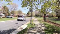
...FLOOD WATCH REMAINS IN EFFECT THROUGH LATE TONIGHT...
* WHAT...Flooding caused by excessive rainfall continues to be
possible.
* WHERE...Portions of southeast Maryland, including the following
areas, Dorchester, Inland Worcester, Maryland Beaches, Somerset
and Wicomico and southeast Virginia, including the following area,
Accomack.
* WHEN...Through late tonight.
* IMPACTS...Excessive runoff may result in flooding of rivers,
creeks, streams, and other low-lying and flood-prone locations.
Flooding may occur in poor drainage and urban areas.
* ADDITIONAL DETAILS...
- A slow moving cold front approaches from the north later this
afternoon into tonight. Due to the humid airmass in place,
any showers or thunderstorms will have the potential to
produce locally heavy rainfall. Localized rainfall amounts of
2 to 4 inches are possible, with rainfall rates potentially
exceeding 2 inches per hour.
- http://www.weather.gov/safety/flood
PRECAUTIONARY/PREPAREDNESS ACTIONS...
You should monitor later forecasts and be alert for possible Flood
Warnings. Those living in areas prone to flooding should be prepared
to take action should flooding develop.
&&