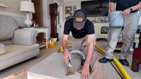
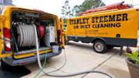
  • Facebook
  • Twitter
  • LinkedIn
  • YouTube
  • Instagram
  • Sign Up
  • Log In
  • Dashboard
  • Logout
    • My Account
    • Dashboard
    • Profile
    • Saved items
    • Logout
Home
  • About WBOC
  • Our Team
  • Programming
  • Contact Us
  • Careers
  • Internships
  • Policies
  • Report It
  • Get our newsletters
  • WBOC Apps
News
  • Wicomico County
  • Worcester County
  • Somerset County
  • Dorchester County
  • Caroline County
  • Talbot County
  • Queen Annes County
  • Sussex County
  • Kent County
  • Accomack County
  • National News
  • International News
  • Latest Newscasts
  • Video Center
Weather
  • Forecast
  • Radar
  • Satellite
  • On The Waters
  • Weather Cameras
  • Closings
Delmarva Sports Network
Shows
  • DelmarvaLife
  • Outdoors Delmarva
  • Delmarva Home Show
Features
  • Bless Our Children
  • Holiday House
  • Obituaries
  • Heartbeat of Delmarva
  • Proud To Serve
  • The M Report
  • Farming Our Future
  • Farm to Table Scholarship
  • Events: Job Fair
Radio
  • WDEL
  • 100.9% Classic Country
  • 107.1 The Duck
  • 102.5 WBOC FM
  • 93.5 The Beach
  • 107.7 BIG Classic Rock
  • 103.9 & 106.3 Coast Country
  • 93.7 WSTW
  • WXCY 103.7 & 96.9
  • WCEI 96.7
  • 94.3 Dockside
  • Watch Live
  • Apps
  • Contact Us
  • My Account
  • Sign Up
  • Log In
  • Dashboard
  • Logout
    • My Account
    • Dashboard
    • Profile
    • Saved items
    • Logout
  • Facebook
  • Twitter
  • LinkedIn
  • YouTube
  • Instagram
  • 16° Clear
    • Salisbury, MD (21801)

      Today

      Some clouds. Very cold. Low 9F. Winds light and variable..

      Tonight

      Some clouds. Very cold. Low 9F. Winds light and variable.

      Updated: January 30, 2026 @ 7:20 pm

    • Full Forecast
site-logo
Watch Live

Newscast Schedule

View Programming Schedule
site-logo
  • 16°
  • Home
  • News
    • Wicomico County
    • Worcester County
    • Somerset County
    • Dorchester County
    • Caroline County
    • Talbot County
    • Queen Anne's County
    • Sussex County
    • Kent County
    • Accomack County
    • National News
    • International News
    • Latest Newscasts
    • Video Center
    • Report It
  • Weather
    • Forecast
    • Radar
    • Satellite
    • On The Waters
    • Weather Cameras
    • Closings
  • Delmarva Sports Network
  • Shows
    • DelmarvaLife
    • Outdoors Delmarva
    • Delmarva Home Show
  • Features
    • Bless Our Children
    • Holiday House
    • Obituaries
    • Heartbeat of Delmarva
    • The M Report
    • Proud To Serve
    • Farming Our Future
    • Farm to Table Scholarship
    • Jefferson Awards
    • Delmarva Experts
    • Events: Job Fair
  • Radio
    • WDEL
    • 100.9% Classic Country
    • 107.1 The Duck
    • 93.5 The Beach
    • 107.7 BIG Classic Rock
    • 103.9 & 106.3 Coast Country
    • 102.5 WBOC FM
    • 93.7 WSTW
    • WXCY 103.7 & 96.9
    • WCEI 96.7
    • 94.3 WINX
  • About Us
    • About WBOC
    • Our Team
    • Channel Finder
    • Apps
    • Contact Us
    • Get our newsletters
    • Careers
    • Internships
    • Policies
    • WBOC Solar Farm
  • Report It

WINTER STORM

Download Weather App

Broadcast Schedule

On air schedule

Weather Alert

Weather Alert

...COLD WEATHER ADVISORY REMAINS IN EFFECT FROM 1 AM SATURDAY TO 1
AM EST SUNDAY...
...WIND ADVISORY IN EFFECT FROM 10 PM SATURDAY TO 4 PM EST SUNDAY...
...EXTREME COLD WATCH REMAINS IN EFFECT FROM LATE SATURDAY NIGHT
THROUGH SUNDAY MORNING...

* WHAT...For the Cold Weather Advisory, very cold wind chills as low
as 3 below expected. For the Wind Advisory, north winds 20 to 30
mph with gusts up to 50 mph expected. For the Extreme Cold Watch,
dangerously cold wind chills as low as 6 below possible.

* WHERE...Inland Worcester, Maryland Beaches, Somerset, and Wicomico
Counties.

* WHEN...For the Cold Weather Advisory, from 1 AM Saturday to 1 AM
EST Sunday. For the Wind Advisory, from 10 PM Saturday to 4 PM EST
Sunday. For the Extreme Cold Watch, from late Saturday night
through Sunday morning.

* IMPACTS...Gusty winds will blow around unsecured objects. Tree
limbs could be blown down and a few power outages may result. The
cold wind chills as low as 5 below zero could result in
hypothermia if precautions are not taken.

PRECAUTIONARY/PREPAREDNESS ACTIONS...

Winds this strong can make driving difficult, especially for high
profile vehicles. Use extra caution.

Dress in layers including a hat, face mask, and gloves if you must
go outside.

Keep pets indoors as much as possible.

Make frequent checks on older family, friends, and neighbors. Ensure
portable heaters are used correctly. Do not use generators or grills
inside.

Monitor the latest forecasts and warnings for updates.

Use caution while traveling outside. Wear appropriate clothing, a
hat, and gloves.

&&

Weather Alert

...WINTER WEATHER ADVISORY IN EFFECT FROM 7 AM SATURDAY TO 4 PM EST
SUNDAY...

* WHAT...Snow expected. Total snow accumulations of 1 to 2 inches.
Winds gusting as high as 45 mph.

* WHERE...Dorchester and Wicomico Counties.

* WHEN...From 7 AM Saturday to 4 PM EST Sunday.

* IMPACTS...Plan on slippery road conditions. Gusty winds could
bring down tree branches.

PRECAUTIONARY/PREPAREDNESS ACTIONS...

Slow down and use caution while traveling. Call 511 for road
information.

&&

Weather Alert

...SMALL CRAFT ADVISORY REMAINS IN EFFECT FROM MIDNIGHT TONIGHT
TO 6 PM EST SATURDAY...
...GALE WARNING IN EFFECT FROM 6 PM SATURDAY TO MIDNIGHT EST
SUNDAY NIGHT...
...HEAVY FREEZING SPRAY WARNING IN EFFECT FROM 1 AM TO 10 AM EST
SUNDAY...

* WHAT...For the Small Craft Advisory, north winds 10 to 20 kt
with gusts up to 25 kt expected. For the Gale Warning, north
winds 25 to 35 kt with gusts up to 45 kt and waves 3 to 6 ft
expected. For the Heavy Freezing Spray Warning, heavy freezing
spray at a rate of 2 cm per hour or greater expected, and may
rapidly accumulate on vessels.

* WHERE...Chesapeake Bay from Drum Point MD to Smith Point VA,
and Tangier Sound and the inland waters surrounding
Bloodsworth Island.

* WHEN...For the Small Craft Advisory, from midnight tonight to
6 PM EST Saturday. For the Gale Warning, from 6 PM Saturday to
midnight EST Sunday night. For the Heavy Freezing Spray
Warning, from 1 AM to 10 AM EST Sunday.

* IMPACTS...Operating a vessel in heavy freezing spray is
hazardous. Freezing spray may render mechanical and electronic
components inoperative. Rapid ice accretion on decks and
superstructures may result in a catastrophic loss of
stability. Strong winds will cause hazardous waves which could
capsize or damage vessels.

PRECAUTIONARY/PREPAREDNESS ACTIONS...

Mariners should prepare for dangerous accumulation of ice on
their vessel. If possible, remain in port, avoid the warning area
or conduct mitigation.

Mariners should alter plans to avoid these hazardous conditions.
Remain in port, seek safe harbor, alter course, and/or secure the
vessel for hazardous conditions.

&&

Closings

Click here to view closings and delays

Advanced Search Close Search
From
To
Close Search
4:49
Stanley Steemer Explains How They Keep Homes Clean During the Winter Season
Delmarvalife

Stanley Steemer Explains How They Keep Homes Clean During the Winter Season

  • Updated 3 hrs ago

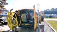
The winter weather might have you tracking in snow and salt through your home, and Stanley Steemer explains how they can help keep your home clean.

3:48
The Summer Weather may Wear Out Your Outdoor Furniture, but Stanley Steemer is Here to Help
Delmarvalife

The Summer Weather may Wear Out Your Outdoor Furniture, but Stanley Steemer is Here to Help

  • Updated Jul 8, 2025

Summer weather can take a toll on our outdoor furniture, and Stanley Steemer explains how they can help keep everything clean.

3:45
Stanley Steemer are More Than Ready to Keep Your House Clean and Tidy
Delmarvalife

Stanley Steemer are More Than Ready to Keep Your House Clean and Tidy

  • Updated Jun 10, 2025

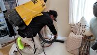
Increased summer activity can mean more sand and dirt getting tracked through the house, but Stanley Steemer describes how they can keep every…

4:14
Stanley Steemer Is The Perfect Team To Clean Your Home Before The Holidays
Delmarvalife

Stanley Steemer Is The Perfect Team To Clean Your Home Before The Holidays

  • Updated Dec 12, 2024

If you need to get your home in clean condition before the holidays, we'll share how Stanley Steemer is the perfect team to call.

4:32
Stanley Steemer Demonstrates How Easy It Is Cleaning Your Carpets Following The Seasonal Festivities
Delmarvalife

Stanley Steemer Demonstrates How Easy It Is Cleaning Your Carpets Following The Seasonal Festivities

  • Updated Nov 21, 2024

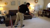
Keeping your carpets clean ahead of all of the seasonal festivities might sound challenging, but Stanley Steemer demonstrates just how easy it is.

4:29
Stanely Steemer Cleans Your Summer Messes
Delmarvalife

Stanely Steemer Cleans Your Summer Messes

  • Updated Aug 20, 2024

Kids and pets can certainly cause stains and make messes, so we meet with Stanley Steemer, the perfect team to keep things clean.

4:29
Outdoor Furniture Looks Brand New with a Visit from Stanley Steemer
Delmarvalife

Outdoor Furniture Looks Brand New with a Visit from Stanley Steemer

  • Updated Jul 22, 2024

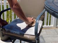
The team at Stanley Steemer can ensure you're getting the most out of your outdoor furniture by keeping it in pristine condition, we'll check …

4:10
Stanley Steemer Experts Share Carpet Cleaning Process
Delmarvalife

Stanley Steemer Experts Share Carpet Cleaning Process

  • Updated Jul 3, 2024

The experts at Stanley Steemer are committed to quality carpet cleaning, we'll learn more about their process.

4:53
We Take A Look At How Stanley Steemer Can Help You Take Care Of Some Of Your Biggest Messes
Delmarvalife

We Take A Look At How Stanley Steemer Can Help You Take Care Of Some Of Your Biggest Messes

  • Updated Oct 20, 2023

Seems Like No Matter The Season, We're Traipsing Some Sort Of Sand, Leaves Or Muck Into The House. Stanley Steemer Shares How To Avoid The Mess.

Paid Content by Stanley Steemer – Back-to-School Cleaning
Delmarvalife

Paid Content by Stanley Steemer – Back-to-School Cleaning

  • By Lisa Bryant
  • Aug 24, 2022

Not too many things can make you feel as refreshed and rejuvenated as a clean home. Find out how one call to Stanley Steemer can make that happen.

  •  
  • 1 of 6
  •  
site-logo
  • Facebook
  • Twitter
  • LinkedIn
  • YouTube
  • Instagram

Sections

  • Latest Newscasts
  • Local News
  • Weather
  • Features
  • DelmarvaLife
  • Outdoors Delmarva
  • Delmarva Home Show
  • CoastTV
  • Telemundo Delmarva
  • Delmarva Sports Network
  • Video Center

Services

  • Search
  • Pay My Bill
  • Advertise With Us
  • Contact Us
  • Careers
  • Internships

Browser Compatibility

Your browser is out of date and potentially vulnerable to security risks.
We recommend switching to one of the following browsers:

Microsoft Edge Google Chrome Firefox
FCC Public File Applications & Related Materials EEO Public File Report FCC Closed Captioning Concerns Children's Programming Transparency Requirements for Group Health Plans
© Copyright 2026 WBOC TV 1729 N. Salisbury BLVD, Salisbury, MD  | Terms of Use  | Privacy Policy
Powered by BLOX Content Management System from BLOX Digital.