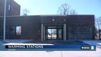
  • Facebook
  • Twitter
  • LinkedIn
  • YouTube
  • Instagram
  • Sign Up
  • Log In
  • Dashboard
  • Logout
    • My Account
    • Dashboard
    • Profile
    • Saved items
    • Logout
Home
  • About WBOC
  • Our Team
  • Programming
  • Contact Us
  • Careers
  • Internships
  • Policies
  • Report It
  • Get our newsletters
  • WBOC Apps
Unbridled Tradition: Pony Swim Special
News
  • Wicomico County
  • Worcester County
  • Somerset County
  • Dorchester County
  • Caroline County
  • Talbot County
  • Queen Annes County
  • Sussex County
  • Kent County
  • Accomack County
  • National News
  • International News
  • Latest Newscasts
  • Video Center
Weather
  • Forecast
  • Radar
  • Satellite
  • On The Waters
  • Weather Cameras
  • Closings
Delmarva Sports Network
Shows
  • DelmarvaLife
  • Outdoors Delmarva
  • Delmarva Home Show
Features
  • Obituaries
  • Heartbeat of Delmarva
  • Proud To Serve
  • Back to School
  • The M Report
  • Farming Our Future
  • Farm to Table Scholarship
  • Bless Our Children
  • Events: Shore Living Expo
Radio
  • 100.9% Classic Country WAAI
  • 107.1 The Duck
  • 102.5 WBOC FM
  • 93.5 The Beach
  • 107.7 BIG Classic Rock
  • 103.9 and 106.3 Coast Country
  • Watch Live
  • Apps
  • Contact Us
  • My Account
  • Sign Up
  • Log In
  • Dashboard
  • Logout
    • My Account
    • Dashboard
    • Profile
    • Saved items
    • Logout
  • Facebook
  • Twitter
  • LinkedIn
  • YouTube
  • Instagram
  • 70° Sunny
    • Salisbury, MD (21801)

      Today

      Sunny. High 71F. Winds SSW at 5 to 10 mph..

      Tonight

      Clear to partly cloudy. Low 53F. Winds S at 5 to 10 mph.

      Updated: October 18, 2025 @ 3:05 pm

    • Full Forecast
site-logo
Watch Live

Newscast Schedule

View Programming Schedule
site-logo
  • 70°
  • Home
  • News
    • Wicomico County
    • Worcester County
    • Somerset County
    • Dorchester County
    • Caroline County
    • Talbot County
    • Queen Annes County
    • Sussex County
    • Kent County
    • Accomack County
    • National News
    • International News
    • Latest Newscasts
    • Video Center
    • Report It
  • Weather
    • Forecast
    • Radar
    • Satellite
    • On The Waters
    • Weather Cameras
    • Closings
  • Delmarva Sports Network
  • Shows
    • DelmarvaLife
    • Outdoors Delmarva
    • Delmarva Home Show
  • Features
    • Unbridled Tradition: Pony Swim Special
    • Obituaries
    • Heartbeat of Delmarva
    • Back to School
    • The M Report
    • Proud To Serve
    • Farming Our Future
    • Farm to Table Scholarship
    • Jefferson Awards
    • Delmarva Experts
    • Bless Our Children
    • Events: Shore Living Expo
  • Radio
    • 100.9% Classic Country WAAI
    • 107.1 The Duck
    • 93.5 The Beach
    • 107.7 BIG Classic Rock
    • 103.9 and 106.3 Coast Country
    • 102.5 WBOC FM
  • About Us
    • About WBOC
    • Our Team
    • Channel Finder
    • Apps
    • Contact Us
    • Get our newsletters
    • Careers
    • Internships
    • Policies
    • WBOC Solar Farm
  • Report It
Broadcast Schedule

On air schedule

Weather Alert

Weather Alert

...COASTAL FLOOD STATEMENT REMAINS IN EFFECT UNTIL 5 PM EDT THIS
AFTERNOON...

* WHAT...Up to one foot of inundation above ground level
expected in low-lying areas near shorelines and tidal
waterways.

* WHERE...Dorchester, Wicomico and Somerset Counties.

* WHEN...From 9 AM EDT this morning through this afternoon.

* IMPACTS...Shallow flooding is possible in the most vulnerable
locations near the waterfront and shoreline.

PRECAUTIONARY/PREPAREDNESS ACTIONS...

Do not drive through flooded roadways.

&&

Time of high total tides are approximate to the nearest hour.

CAMBRIDGE MD
MLLW CATEGORIES - MINOR 3.5 FT, MODERATE 4.0 FT, MAJOR 4.5 FT
MHHW CATEGORIES - MINOR 1.5 FT, MODERATE 2.0 FT, MAJOR 2.5 FT

TOTAL      TOTAL    DEPARTURE
DAY/TIME    TIDE       TIDE     FROM NORM   WAVES    FLOOD
FT MLLW    FT MHHW       FT       FT      IMPACT
--------  ---------  ---------  ---------  -------  --------
18/03 PM     3.5        1.5        1.4        1      MINOR
19/03 AM     3.5        1.5        1.5        1      MINOR
19/03 PM     3.6        1.6        1.5        2      MINOR
20/03 AM     3.9        1.9        2.0        2      MINOR
20/04 PM     3.3        1.3        1.1       1-2      NONE

BISHOPS HEAD MD
MLLW CATEGORIES - MINOR 3.2 FT, MODERATE 3.7 FT, MAJOR 4.2 FT
MHHW CATEGORIES - MINOR 1.1 FT, MODERATE 1.6 FT, MAJOR 2.1 FT

TOTAL      TOTAL    DEPARTURE
DAY/TIME    TIDE       TIDE     FROM NORM   WAVES    FLOOD
FT MLLW    FT MHHW       FT       FT      IMPACT
--------  ---------  ---------  ---------  -------  --------
18/12 PM     3.5        1.4        1.2        1      MINOR
19/01 AM     3.5        1.4        1.4       1-2     MINOR
19/01 PM     3.8        1.7        1.5       2-3    MODERATE
20/01 AM     3.9        1.8        1.8        3     MODERATE
20/01 PM     3.2        1.1        0.9       2-3     MINOR
21/02 AM     2.6        0.5        0.6        1       NONE

CRISFIELD MD
MLLW CATEGORIES - MINOR 3.5 FT, MODERATE 4.0 FT, MAJOR 5.0 FT
MHHW CATEGORIES - MINOR 1.3 FT, MODERATE 1.8 FT, MAJOR 2.8 FT

TOTAL      TOTAL    DEPARTURE
DAY/TIME    TIDE       TIDE     FROM NORM   WAVES    FLOOD
FT MLLW    FT MHHW       FT       FT      IMPACT
--------  ---------  ---------  ---------  -------  --------
18/11 AM     3.4        1.2        1.6        1       NONE
18/11 PM     3.5        1.3        1.7        1      MINOR
19/12 PM     3.6        1.4        1.7        1      MINOR
20/01 AM     3.9        1.7        2.1        1      MINOR
20/12 PM     3.6        1.4        1.6        1      MINOR
21/01 AM     2.7        0.5        0.9        1       NONE

&&

Weather Alert

...SMALL CRAFT ADVISORY IN EFFECT FROM 11 PM THIS EVENING TO 2 AM
EDT MONDAY...

* WHAT...South winds 15 to 25 kt with gusts up to 30 kt and
waves 2 to 4 ft expected.

* WHERE...Chesapeake Bay from North Beach MD to Smith Point VA,
Tidal Potomac from Cobb Island MD to Smith Point VA, and
Tangier Sound and the inland waters surrounding Bloodsworth
Island.

* WHEN...From 11 PM this evening to 2 AM EDT Monday.

* IMPACTS...Conditions will be hazardous to small craft.

PRECAUTIONARY/PREPAREDNESS ACTIONS...

Inexperienced mariners, especially those operating smaller
vessels, should avoid navigating in hazardous conditions.

&&

eclipse


Advanced Search Close Search
From
To
Close Search
3:03
People Across The Peninsula Are Finding Ways To Outwork The Blistering Temperatures
Latest News

People Across The Peninsula Are Finding Ways To Outwork The Blistering Temperatures

  • Updated Jun 23, 2025

When temperatures approach triple digits, it can make it difficult, even dangerous, to be outside. Some people, however, don't have a choice. …

2:58
Charging Ahead: Delaware Invests $21.5M in EV Chargers for Major Highways
Latest News

Charging Ahead: Delaware Invests $21.5M in EV Chargers for Major Highways

  • Updated Nov 1, 2024

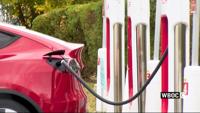
The Delaware Department of Transportation (DelDOT) is moving forward with a $21.5 million initiative to install up to 10 new electric vehicle …

2:30
Delaware Gas Prices Down
Latest News

Delaware Gas Prices Down

  • Updated Oct 17, 2023

Drivers in Sussex County are finding relief as gas prices have significantly decreased, with many stations now below the $3 mark.

site-logo
  • Facebook
  • Twitter
  • LinkedIn
  • YouTube
  • Instagram

Sections

  • Latest Newscasts
  • Local News
  • Weather
  • Features
  • DelmarvaLife
  • Outdoors Delmarva
  • Delmarva Home Show
  • CoastTV
  • Telemundo Delmarva
  • Delmarva Sports Network
  • Video Center

Services

  • Search
  • Pay My Bill
  • Advertise With Us
  • Contact Us
  • Careers
  • Internships

Browser Compatibility

Your browser is out of date and potentially vulnerable to security risks.
We recommend switching to one of the following browsers:

Microsoft Edge Google Chrome Firefox
FCC Public File Applications & Related Materials EEO Public File Report FCC Closed Captioning Concerns Children's Programming Transparency Requirements for Group Health Plans
© Copyright 2025 WBOC TV 1729 N. Salisbury BLVD, Salisbury, MD  | Terms of Use  | Privacy Policy
Powered by BLOX Content Management System from BLOX Digital.