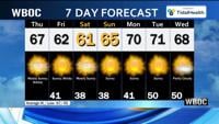


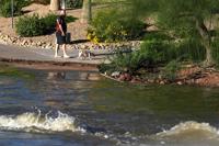
A chaotic climate phenomenon called El Niño is intensifying heavy rains and floods in the Southwest. Experts say the natural warming cycle is sizzling Pacific Ocean waters and leaking moisture into the air that can fuel passing storms. The phenomenon wasn’t the only cause, but scientists say it’s making heavy rains more likely and intense across the Southern U.S. Flash floods on Sunday prompted evacuations across northern New Mexico and central Arizona, and a Colorado ski town braced for its main river to rise to catastrophic levels. To stay safe, experts recommended watching the forecast, planning ahead and heeding evacuation warnings.
From
To



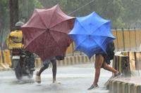
Officials say Cyclone Arnab crossed India’s Andhra Pradesh coast in the early hours of Wednesday, a day after tens of thousands of people were forced to evacuate from vulnerable coastal areas in the eastern state. The state’s disaster management authority says the cyclone had weakened slightly before landfall but still packed peak winds of up to 115 miles per hour. Arnab brought heavy to very heavy rainfall to several coastal districts, triggering widespread disruption in affected areas. At least 89,000 people have so far been evacuated in Andhra Pradesh, according to an official statement. In neighboring Odisha, officials plan to evacuate about 48,000 people from areas likely to be affected by the storm.
Indian authorities have evacuated tens of thousands of people from vulnerable coastal areas in the eastern state of Andhra Pradesh as a severe cyclone over the Bay of Bengal is expected to make landfall along the country’s east coast. The India Meteorological Department says Cyclone Arnab strengthened into a “very severe” cyclonic storm and was expected to make landfall along the Andhra Pradesh coast by early Wednesday morning with gusting winds and heavy rain. At least 89,000 people have so far been evacuated in Andhra Pradesh, according to an official statement.
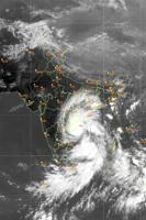
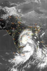
This screen grab, taken from the India Meteorological Department website, shows the storm Arnab over west central Bay of Bengal, India, Tuesday, Oct. 27, 2026. (India Meteorological Department via AP)


A rain-soaked swath of the Southwest U.S. is bracing for another round of potentially heavy showers and thunderstorms after days of rain forced evacuations and water rescues. The National Weather Service issued a flood watch Sunday for much of the Four Corners region — the meeting point of Arizona, Colorado, New Mexico and Utah. Though local officials forecast further receding of swollen rivers, they said many residents remained evacuated and without power.


Vice President JD Vance is traveling the U.S. supporting Republican candidates, while another Vance is on a whirlwind tour off Mexico's Pacific Coast. The storm named Vance strengthened into a hurricane on Friday, but it's not named after the vice president. The World Meteorological Organization picked Vance as one of the names on this year's Pacific storm list. This follows Hurricane Trudy, which also formed off Mexico last week. Social media had fun with the coincidence, with many users sharing memes of the vice president's face in the eye of the storm. The next storm named Vance could appear in 2032.


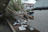
A possible tornado has caused significant damage in a central Arizona community, with trees falling onto homes and utility poles knocked down. Violent storms moved through the state overnight into Thursday. Other areas in northern and central Arizona experienced hail the size of golf balls, shattering windows and denting cars. The National Weather Service issued multiple warnings as severe thunderstorms moved through the state. A tornado warning was in effect Wednesday night as a storm moved over Heber-Overgaard in Navajo County. Significant damage and minor injuries were reported. A weather service meteorologist in Flagstaff says that is unusual for the area at this time of year.