  • Facebook
  • Twitter
  • LinkedIn
  • YouTube
  • Instagram
  • Sign Up
  • Log In
  • Dashboard
  • Logout
    • My Account
    • Dashboard
    • Profile
    • Saved items
    • Logout
Home
  • About WBOC
  • Our Team
  • Programming
  • Contact Us
  • Careers
  • Internships
  • Policies
  • Report It
  • Get our newsletters
  • WBOC Apps
Unbridled Tradition: Pony Swim Special
News
  • Wicomico County
  • Worcester County
  • Somerset County
  • Dorchester County
  • Caroline County
  • Talbot County
  • Queen Annes County
  • Sussex County
  • Kent County
  • Accomack County
  • National News
  • International News
  • Latest Newscasts
  • Video Center
Weather
  • Forecast
  • Radar
  • Satellite
  • On The Waters
  • Weather Cameras
  • Closings
Delmarva Sports Network
Shows
  • DelmarvaLife
  • Outdoors Delmarva
  • Delmarva Home Show
Features
  • Obituaries
  • Heartbeat of Delmarva
  • Proud To Serve
  • Back to School
  • The M Report
  • Farming Our Future
  • Farm to Table Scholarship
  • Bless Our Children
  • Events: Shore Living Expo
Radio
  • 100.9% Classic Country WAAI
  • 107.1 The Duck
  • 102.5 WBOC FM
  • 93.5 The Beach
  • 107.7 BIG Classic Rock
  • 103.9 and 106.3 Coast Country
  • Watch Live
  • Apps
  • Contact Us
  • My Account
  • Sign Up
  • Log In
  • Dashboard
  • Logout
    • My Account
    • Dashboard
    • Profile
    • Saved items
    • Logout
  • Facebook
  • Twitter
  • LinkedIn
  • YouTube
  • Instagram
  • 66° Rain
    • Salisbury, MD (21801)

      Today

      Windy with rain early...then remaining cloudy with showers for the afternoon. High 67F. Winds NE at 20 to 30 mph. Chance of rain 90%. Winds could occasionally gust over 40 mph..

      Tonight

      Showers, with winds diminishing overnight. Low 57F. Winds N at 20 to 30 mph. Chance of rain 60%. Winds could occasionally gust over 40 mph.

      Updated: October 12, 2025 @ 6:43 am

    • Full Forecast
site-logo
Watch Live

Newscast Schedule

View Programming Schedule
site-logo
  • 66°
  • Home
  • News
    • Wicomico County
    • Worcester County
    • Somerset County
    • Dorchester County
    • Caroline County
    • Talbot County
    • Queen Annes County
    • Sussex County
    • Kent County
    • Accomack County
    • National News
    • International News
    • Latest Newscasts
    • Video Center
    • Report It
  • Weather
    • Forecast
    • Radar
    • Satellite
    • On The Waters
    • Weather Cameras
    • Closings
  • Delmarva Sports Network
  • Shows
    • DelmarvaLife
    • Outdoors Delmarva
    • Delmarva Home Show
  • Features
    • Unbridled Tradition: Pony Swim Special
    • Obituaries
    • Heartbeat of Delmarva
    • Back to School
    • The M Report
    • Proud To Serve
    • Farming Our Future
    • Farm to Table Scholarship
    • Jefferson Awards
    • Delmarva Experts
    • Bless Our Children
    • Events: Shore Living Expo
  • Radio
    • 100.9% Classic Country WAAI
    • 107.1 The Duck
    • 93.5 The Beach
    • 107.7 BIG Classic Rock
    • 103.9 and 106.3 Coast Country
    • 102.5 WBOC FM
  • About Us
    • About WBOC
    • Our Team
    • Channel Finder
    • Apps
    • Contact Us
    • Get our newsletters
    • Careers
    • Internships
    • Policies
    • WBOC Solar Farm
Broadcast Schedule

On air schedule

Weather Alert

Weather Alert

...COASTAL FLOOD ADVISORY IN EFFECT FROM 3 PM THIS AFTERNOON TO
11 PM EDT THIS EVENING...

* WHAT...Up to one half foot of inundation above ground level
expected in low-lying areas near shorelines and tidal
waterways.

* WHERE...Dorchester, Wicomico and Somerset Counties.

* WHEN...From 3 PM this afternoon to 11 PM EDT this evening.

* IMPACTS...Shallow flooding is expected in the most vulnerable
locations near the waterfront and shoreline resulting in a low
threat of property damage. Expect up to one foot of water
above ground level in low lying, vulnerable areas. Some roads
and low lying property including parking lots, parks and lawns
near the waterfront will experience shallow flooding.

PRECAUTIONARY/PREPAREDNESS ACTIONS...

If travel is required, allow extra time as some roads may be
closed. Do not drive around barricades or through water of
unknown depth. Take the necessary actions to protect flood-prone
property.

&&

Time of high total tides are approximate to the nearest hour.

CAMBRIDGE MD
MLLW CATEGORIES - MINOR 3.5 FT, MODERATE 4.0 FT, MAJOR 4.5 FT
MHHW CATEGORIES - MINOR 1.5 FT, MODERATE 2.0 FT, MAJOR 2.5 FT

TOTAL      TOTAL    DEPARTURE
DAY/TIME    TIDE       TIDE     FROM NORM   WAVES    FLOOD
FT MLLW    FT MHHW       FT       FT      IMPACT
--------  ---------  ---------  ---------  -------  --------
12/08 AM     2.5        0.5        0.6        2       NONE
12/09 PM     3.3        1.3        1.1       1-2      NONE
13/09 AM     3.3        1.3        1.5        1       NONE
13/10 PM     3.2        1.2        1.1        1       NONE
14/10 AM     2.5        0.5        0.7        1       NONE
15/12 AM     2.7        0.7        0.6        1       NONE

BISHOPS HEAD MD
MLLW CATEGORIES - MINOR 3.2 FT, MODERATE 3.7 FT, MAJOR 4.2 FT
MHHW CATEGORIES - MINOR 1.1 FT, MODERATE 1.6 FT, MAJOR 2.1 FT

TOTAL      TOTAL    DEPARTURE
DAY/TIME    TIDE       TIDE     FROM NORM   WAVES    FLOOD
FT MLLW    FT MHHW       FT       FT      IMPACT
--------  ---------  ---------  ---------  -------  --------
12/06 AM     3.0        0.9        0.9        2       NONE
12/06 PM     3.5        1.4        1.2        2      MINOR
13/07 AM     3.5        1.4        1.5        2      MINOR
13/07 PM     3.5        1.4        1.3        1      MINOR
14/08 AM     2.9        0.8        0.9        1       NONE
14/09 PM     3.1        1.0        0.9       1-2      NONE

CRISFIELD MD
MLLW CATEGORIES - MINOR 3.5 FT, MODERATE 4.0 FT, MAJOR 5.0 FT
MHHW CATEGORIES - MINOR 1.3 FT, MODERATE 1.8 FT, MAJOR 2.8 FT

TOTAL      TOTAL    DEPARTURE
DAY/TIME    TIDE       TIDE     FROM NORM   WAVES    FLOOD
FT MLLW    FT MHHW       FT       FT      IMPACT
--------  ---------  ---------  ---------  -------  --------
12/06 AM     2.9        0.7        1.5        1       NONE
12/06 PM     3.8        1.6        1.6        1      MINOR
13/06 AM     3.5        1.3        2.0        1      MINOR
13/06 PM     3.9        1.7        1.8        1      MINOR
14/06 AM     2.7        0.5        1.4        1       NONE
14/08 PM     3.2        1.0        1.2        1       NONE

&&

Weather Alert

...GALE WARNING NOW IN EFFECT UNTIL 8 AM EDT MONDAY...

* WHAT...Northeast winds 20 to 30 kt with gusts up to 40 kt and
waves 3 to 6 ft expected.

* WHERE...Chesapeake Bay from Drum Point MD to Smith Point VA,
Tidal Potomac from Cobb Island MD to Smith Point VA and
Tangier Sound and the inland waters surrounding Bloodsworth
Island.

* WHEN...Until 8 AM EDT Monday.

* IMPACTS...Strong winds will cause hazardous waves which could
capsize or damage vessels.

PRECAUTIONARY/PREPAREDNESS ACTIONS...

Mariners should alter plans to avoid these hazardous conditions.
Remain in port, seek safe harbor, alter course, and/or secure the
vessel for hazardous conditions.

&&

eclipse


Closings

Click here to view closings and delays

Advanced Search Close Search
From
To
Close Search
6:42
The Difference Between A Stromboli And A Calzone With Chef Joe Bellia From Joe's La Roma
Delmarvalife

The Difference Between A Stromboli And A Calzone With Chef Joe Bellia From Joe's La Roma

  • Updated Jan 23, 2025

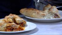
We learn the difference between a classic Stromboli and a Calzone from Chef Joe Bellia from Joe's La Roma.

site-logo
  • Facebook
  • Twitter
  • LinkedIn
  • YouTube
  • Instagram

Sections

  • Latest Newscasts
  • Local News
  • Weather
  • Features
  • DelmarvaLife
  • Outdoors Delmarva
  • Delmarva Home Show
  • CoastTV
  • Telemundo Delmarva
  • Delmarva Sports Network
  • Video Center

Services

  • Search
  • Pay My Bill
  • Advertise With Us
  • Contact Us
  • Careers
  • Internships

Browser Compatibility

Your browser is out of date and potentially vulnerable to security risks.
We recommend switching to one of the following browsers:

Microsoft Edge Google Chrome Firefox
FCC Public File Applications & Related Materials EEO Public File Report FCC Closed Captioning Concerns Children's Programming Transparency Requirements for Group Health Plans
© Copyright 2025 WBOC TV 1729 N. Salisbury BLVD, Salisbury, MD  | Terms of Use  | Privacy Policy
Powered by BLOX Content Management System from BLOX Digital.