  • Facebook
  • Twitter
  • LinkedIn
  • YouTube
  • Instagram
  • Sign Up
  • Log In
  • Dashboard
  • Logout
    • My Account
    • Dashboard
    • Profile
    • Saved items
    • Logout
Home
  • About WBOC
  • Our Team
  • Programming
  • Contact Us
  • Careers
  • Internships
  • Policies
  • Report It
  • Get our newsletters
  • WBOC Apps
Spirits of the Shore
News
  • Wicomico County
  • Worcester County
  • Somerset County
  • Dorchester County
  • Caroline County
  • Talbot County
  • Queen Annes County
  • Sussex County
  • Kent County
  • Accomack County
  • National News
  • International News
  • Latest Newscasts
  • Video Center
Weather
  • Forecast
  • Radar
  • Satellite
  • On The Waters
  • Weather Cameras
  • Closings
Delmarva Sports Network
Shows
  • DelmarvaLife
  • Outdoors Delmarva
  • Delmarva Home Show
Features
  • Obituaries
  • Heartbeat of Delmarva
  • Proud To Serve
  • Back to School
  • The M Report
  • Farming Our Future
  • Farm to Table Scholarship
  • Bless Our Children
  • Events: Job Fair
Radio
  • 100.9% Classic Country WAAI
  • 107.1 The Duck
  • 102.5 WBOC FM
  • 93.5 The Beach
  • 107.7 BIG Classic Rock
  • 103.9 and 106.3 Coast Country
  • Watch Live
  • Apps
  • Contact Us
  • My Account
  • Sign Up
  • Log In
  • Dashboard
  • Logout
    • My Account
    • Dashboard
    • Profile
    • Saved items
    • Logout
  • Facebook
  • Twitter
  • LinkedIn
  • YouTube
  • Instagram
  • 68° Cloudy
    • Salisbury, MD (21801)

      Today

      Rain showers this morning with some sunshine during the afternoon hours. High 69F. Winds SSW at 10 to 15 mph. Chance of rain 70%..

      Tonight

      A few passing clouds. Low 49F. Winds W at 10 to 15 mph.

      Updated: October 30, 2025 @ 10:27 am

    • Full Forecast
site-logo
Watch Live

Newscast Schedule

View Programming Schedule
site-logo
  • 68°
  • Home
  • News
    • Wicomico County
    • Worcester County
    • Somerset County
    • Dorchester County
    • Caroline County
    • Talbot County
    • Queen Anne's County
    • Sussex County
    • Kent County
    • Accomack County
    • National News
    • International News
    • Latest Newscasts
    • Video Center
    • Report It
  • Weather
    • Forecast
    • Radar
    • Satellite
    • On The Waters
    • Weather Cameras
    • Closings
  • Delmarva Sports Network
  • Shows
    • DelmarvaLife
    • Outdoors Delmarva
    • Delmarva Home Show
  • Features
    • Spirits of the Shore
    • Obituaries
    • Heartbeat of Delmarva
    • Back to School
    • The M Report
    • Proud To Serve
    • Farming Our Future
    • Farm to Table Scholarship
    • Jefferson Awards
    • Delmarva Experts
    • Bless Our Children
    • Events: Job Fair
  • Radio
    • 100.9% Classic Country WAAI
    • 107.1 The Duck
    • 93.5 The Beach
    • 107.7 BIG Classic Rock
    • 103.9 and 106.3 Coast Country
    • 102.5 WBOC FM
  • About Us
    • About WBOC
    • Our Team
    • Channel Finder
    • Apps
    • Contact Us
    • Get our newsletters
    • Careers
    • Internships
    • Policies
    • WBOC Solar Farm
  • Report It
Broadcast Schedule

On air schedule

Weather Alert

Weather Alert

...COASTAL FLOOD WARNING REMAINS IN EFFECT UNTIL 4 AM EDT
FRIDAY...

* WHAT...Two to three feet of inundation above ground level
expected in low-lying areas near shorelines and tidal
waterways.

* WHERE...Dorchester, Wicomico and Somerset Counties.

* WHEN...Until 4 AM EDT Friday.

* IMPACTS...Severe flooding will cause extensive inundation and
flooding of numerous roads and buildings resulting in a
significant threat to property and life. Water will be 2 to 3
feet or more above ground level in some areas. Severe flooding
will extend inland from the waterfront and shoreline flooding
homes, businesses and isolating some neighborhoods. Numerous
roads will be impassable under several feet of water and cars
submerged. Some areas will need to be evacuated.

PRECAUTIONARY/PREPAREDNESS ACTIONS...

Take the necessary actions to protect flood-prone property. If
travel is required, do not drive around barricades or through
water of unknown depth.

&&

Time of high total tides are approximate to the nearest hour.

CAMBRIDGE MD
MLLW CATEGORIES - MINOR 3.5 FT, MODERATE 4.0 FT, MAJOR 4.5 FT
MHHW CATEGORIES - MINOR 1.5 FT, MODERATE 2.0 FT, MAJOR 2.5 FT

TOTAL      TOTAL    DEPARTURE
DAY/TIME    TIDE       TIDE     FROM NORM   WAVES    FLOOD
FT MLLW    FT MHHW       FT       FT      IMPACT
--------  ---------  ---------  ---------  -------  --------
30/11 AM     4.5        2.5        2.8       1-2     MAJOR
31/12 AM     4.2        2.2        2.2       1-2    MODERATE
31/11 AM     3.6        1.6        1.9        2      MINOR
01/12 AM     2.9        0.9        0.9        2       NONE
01/01 PM     2.3        0.3        0.4        1       NONE
02/01 AM     2.0        0.0        0.0        1       NONE

BISHOPS HEAD MD
MLLW CATEGORIES - MINOR 3.2 FT, MODERATE 3.7 FT, MAJOR 4.2 FT
MHHW CATEGORIES - MINOR 1.1 FT, MODERATE 1.6 FT, MAJOR 2.1 FT

TOTAL      TOTAL    DEPARTURE
DAY/TIME    TIDE       TIDE     FROM NORM   WAVES    FLOOD
FT MLLW    FT MHHW       FT       FT      IMPACT
--------  ---------  ---------  ---------  -------  --------
30/08 AM     4.4        2.3        2.7       2-3     MAJOR
30/08 PM     4.4        2.3        2.5       2-3     MAJOR
31/09 AM     3.5        1.4        1.7       2-3     MINOR
31/10 PM     3.0        0.9        1.0       2-3      NONE
01/10 AM     2.6        0.5        0.6       1-2      NONE
01/10 PM     2.3        0.2        0.3        1       NONE

CRISFIELD MD
MLLW CATEGORIES - MINOR 3.5 FT, MODERATE 4.0 FT, MAJOR 5.0 FT
MHHW CATEGORIES - MINOR 1.3 FT, MODERATE 1.8 FT, MAJOR 2.8 FT

TOTAL      TOTAL    DEPARTURE
DAY/TIME    TIDE       TIDE     FROM NORM   WAVES    FLOOD
FT MLLW    FT MHHW       FT       FT      IMPACT
--------  ---------  ---------  ---------  -------  --------
30/08 AM     4.2        2.0        2.7        1     MODERATE
30/08 PM     4.5        2.3        2.5        1     MODERATE
31/07 AM     3.8        1.6        2.4        1      MINOR
31/09 PM     3.2        1.0        1.2        1       NONE
01/10 AM     2.5        0.3        0.7        1       NONE
01/10 PM     2.3        0.1        0.3        1       NONE

&&

Weather Alert

...SMALL CRAFT ADVISORY REMAINS IN EFFECT UNTIL 6 AM EDT FRIDAY...
...GALE WATCH REMAINS IN EFFECT FROM FRIDAY MORNING THROUGH
FRIDAY AFTERNOON...

* WHAT...For the Small Craft Advisory, east winds becoming
southwest 15 to 25 kt with gusts up to 30 kt and waves 2 to 4
ft. For the Gale Watch, west winds 15 to 25 kt with gusts up to
35 kt and waves 2 to 4 ft possible.

* WHERE...Chesapeake Bay main channel north of Smith Point VA,
Tidal Potomac from Cobb Island MD to Smith Point VA, Chester
River to Queenstown MD, Eastern Bay, Choptank River to
Cambridge MD and the Little Choptank River, Patuxent River to
Broomes Island MD, and Tangier Sound and the inland waters
surrounding Bloodsworth Island.

* WHEN...For the Small Craft Advisory, until 6 AM EDT Friday.
For the Gale Watch, from Friday morning through Friday
afternoon.

* IMPACTS...Strong winds can cause hazardous waves which could
capsize or damage vessels.

PRECAUTIONARY/PREPAREDNESS ACTIONS...

Mariners should consider altering plans to avoid possible
hazardous conditions.  Remain in port, seek safe harbor, alter
course, and/or secure the vessel for severe wind and waves.

&&

Closings

Click here to view closings and delays

      Spirits of the Shore  
Advanced Search Close Search
From
To
Close Search
2:18
Delaware Housing Department task force holds first meeting
Latest News

Delaware Housing Department task force holds first meeting

  • Updated Sep 10, 2025

Delaware's Housing Department Task Force held its first meeting on Wednesday, bringing together lawmakers, housing advocates, and community me…

2:00
Delaware Task Force Unveils Final Report to Tackle Affordable Housing Crisis
Latest News

Delaware Task Force Unveils Final Report to Tackle Affordable Housing Crisis

  • Updated Apr 8, 2025

State leaders are renewing efforts to address the state's ongoing affordable housing crisis following the release of a comprehensive report fr…

1:57
Rehoboth Beach Looks to Expand Mixed-Use Zoning with Task Force
Latest News

Rehoboth Beach Looks to Expand Mixed-Use Zoning with Task Force

  • Updated Feb 27, 2025

Rehoboth Beach's mixed-use zoning ordinance task force held its inaugural meeting Thursday. City leaders said the task force will look at pote…

2:35
Salisbury Considers Housing Task Force to Tackle High Rent
Latest News

Salisbury Considers Housing Task Force to Tackle High Rent

  • Updated Apr 1, 2024

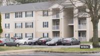
Salisbury is feeling the pinch as rent prices soar. Amid these challenges, community activist Amber Green with the Fenix Youth Project, is cal…

2:25
Wicomico County Task Force Recommends Liquor Dispensary Changes
Latest News

Wicomico County Task Force Recommends Liquor Dispensary Changes

  • Updated Jan 16, 2024

The future of liquor sales in Wicomico County was the topic of conversation at Tuesday's County Council meeting, following a recommendation by…

2:29
Ocean City Officials Continue Pursuit of Sports Complex
Latest News

Ocean City Officials Continue Pursuit of Sports Complex

  • Updated Dec 20, 2023

Efforts are underway in Ocean City as officials strive to bring a sports complex to town, with a dedicated committee formed earlier this year …

site-logo
  • Facebook
  • Twitter
  • LinkedIn
  • YouTube
  • Instagram

Sections

  • Latest Newscasts
  • Local News
  • Weather
  • Features
  • DelmarvaLife
  • Outdoors Delmarva
  • Delmarva Home Show
  • CoastTV
  • Telemundo Delmarva
  • Delmarva Sports Network
  • Video Center

Services

  • Search
  • Pay My Bill
  • Advertise With Us
  • Contact Us
  • Careers
  • Internships

Browser Compatibility

Your browser is out of date and potentially vulnerable to security risks.
We recommend switching to one of the following browsers:

Microsoft Edge Google Chrome Firefox
FCC Public File Applications & Related Materials EEO Public File Report FCC Closed Captioning Concerns Children's Programming Transparency Requirements for Group Health Plans
© Copyright 2025 WBOC TV 1729 N. Salisbury BLVD, Salisbury, MD  | Terms of Use  | Privacy Policy
Powered by BLOX Content Management System from BLOX Digital.