Closed Sunday
Weather Alert
Breaking
...GALE WARNING NOW IN EFFECT FROM 6 PM THIS EVENING TO 6 AM EST
SATURDAY...
...FREEZING SPRAY ADVISORY IN EFFECT FROM 7 PM THIS EVENING TO
1 PM EST SATURDAY...
...SMALL CRAFT ADVISORY IN EFFECT FROM 6 AM TO 10 AM EST
SATURDAY...

* WHAT...For the Gale Warning, north winds 15 to 25 kt with gusts
up to 35 kt and waves 2 to 4 ft expected. For the Freezing Spray
Advisory, moderate accumulation of freezing spray expected. For
the Small Craft Advisory, north winds 15 to 20 kt with gusts up
to 30 kt and waves 2 to 4 ft expected.

* WHERE...Chesapeake Bay from Drum Point MD to Smith Point VA,
Tidal Potomac from Cobb Island MD to Smith Point VA, Patuxent
River to Broomes Island MD and Tangier Sound and the inland
waters surrounding Bloodsworth Island.

* WHEN...For the Gale Warning, from 6 PM this evening to 6 AM
EST Saturday. For the Freezing Spray Advisory, from 7 PM this
evening to 1 PM EST Saturday. For the Small Craft Advisory,
from 6 AM to 10 AM EST Saturday.

* IMPACTS...Operating a vessel in freezing spray is hazardous.
Freezing spray may render mechanical and electronic components
inoperative. Ice accretion on decks and superstructures may
result in some loss of stability. Strong winds will cause
hazardous waves which could capsize or damage vessels.

PRECAUTIONARY/PREPAREDNESS ACTIONS...

Mariners should prepare for ice accumulation on their vessel and
consider altering plans to avoid or mitigate these hazardous
conditions.

Mariners should alter plans to avoid these hazardous conditions.
Remain in port, seek safe harbor, alter course, and/or secure the
vessel for hazardous conditions.

&&
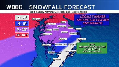
...WINTER STORM WATCH REMAINS IN EFFECT FROM SATURDAY AFTERNOON
THROUGH MONDAY AFTERNOON...

* WHAT...Heavy mixed precipitation possible. Confidence is
increasing in widespread snow, sleet, and freezing rain. This may
result in major impacts in infrastructure and transportation.

* WHERE...Portions of southeast Maryland and central, east central,
and north central Virginia.

* WHEN...From Saturday afternoon through Monday afternoon.

* IMPACTS...Roads, and especially bridges and overpasses, will
become slick and hazardous. The combination of significant snow
and ice accumulation on power lines and tree limbs may cause
widespread and long-lasting power outages.

PRECAUTIONARY/PREPAREDNESS ACTIONS...

Monitor the latest forecasts for updates on this situation.

&&
...COLD WEATHER ADVISORY REMAINS IN EFFECT FROM 8 PM FRIDAY TO 10 AM
EST SATURDAY...

* WHAT...Very cold wind chills between 5 below to 5 above is
expected.

* WHERE...Portions of southeast Maryland and central, east central,
eastern, north central, south central, and southeast Virginia.

* WHEN...From 8 PM Friday to 10 AM EST Saturday.

* IMPACTS...The cold wind chills as low as 5 above could result in
hypothermia if precautions are not taken.

PRECAUTIONARY/PREPAREDNESS ACTIONS...

Use caution while traveling outside. Wear appropriate clothing, a
hat, and gloves.

Make frequent checks on older family, friends, and neighbors. Ensure
portable heaters are used correctly. Do not use generators or grills
inside.

&&
DELMARVA - Chief Meteorologist Mike Lichniak is calling for a significant weather event this weekend as a winter storm approaches the peninsula. More weatherSnowfall expected across Delmarva before transitioning to ice and rain Sunday

Digital Content Producer
Sean joined WBOC as Digital Content Producer in February 2023. Originally from New Jersey, Sean graduated from Rutgers University with bachelor’s degrees in East Asian Studies and Religion. He has lived in New York, California, and Virginia before he and his wife finally found a place to permanently call home in Maryland. With family in Laurel, Ocean Pines, Berlin, and Captain’s Cove, Sean has deep ties to the Eastern Shore and is thrilled to be working at WBOC serving the community.
{{description}}
Email notifications are only sent once a day, and only if there are new matching items.