  • Facebook
  • Twitter
  • LinkedIn
  • YouTube
  • Instagram
  • Sign Up
  • Log In
  • Dashboard
  • Logout
    • My Account
    • Dashboard
    • Profile
    • Saved items
    • Logout
Home
  • About WBOC
  • Our Team
  • Programming
  • Contact Us
  • Careers
  • Internships
  • Policies
  • Report It
  • Get our newsletters
  • WBOC Apps
Spirits of the Shore
News
  • Wicomico County
  • Worcester County
  • Somerset County
  • Dorchester County
  • Caroline County
  • Talbot County
  • Queen Annes County
  • Sussex County
  • Kent County
  • Accomack County
  • National News
  • International News
  • Latest Newscasts
  • Video Center
Weather
  • Forecast
  • Radar
  • Satellite
  • On The Waters
  • Weather Cameras
  • Closings
Delmarva Sports Network
Shows
  • DelmarvaLife
  • Outdoors Delmarva
  • Delmarva Home Show
Features
  • Obituaries
  • Heartbeat of Delmarva
  • Proud To Serve
  • Back to School
  • The M Report
  • Farming Our Future
  • Farm to Table Scholarship
  • Bless Our Children
  • Events: Job Fair
Radio
  • 100.9% Classic Country WAAI
  • 107.1 The Duck
  • 102.5 WBOC FM
  • 93.5 The Beach
  • 107.7 BIG Classic Rock
  • 103.9 and 106.3 Coast Country
  • Watch Live
  • Apps
  • Contact Us
  • My Account
  • Sign Up
  • Log In
  • Dashboard
  • Logout
    • My Account
    • Dashboard
    • Profile
    • Saved items
    • Logout
  • Facebook
  • Twitter
  • LinkedIn
  • YouTube
  • Instagram
  • 55° Sunny
    • Salisbury, MD (21801)

      Today

      Abundant sunshine. High 61F. Winds W at 15 to 25 mph. Higher wind gusts possible..

      Tonight

      Clear skies. Low 44F. Winds W at 10 to 15 mph.

      Updated: October 31, 2025 @ 10:11 am

    • Full Forecast
site-logo
Watch Live

Newscast Schedule

View Programming Schedule
site-logo
  • 55°
  • Home
  • News
    • Wicomico County
    • Worcester County
    • Somerset County
    • Dorchester County
    • Caroline County
    • Talbot County
    • Queen Anne's County
    • Sussex County
    • Kent County
    • Accomack County
    • National News
    • International News
    • Latest Newscasts
    • Video Center
    • Report It
  • Weather
    • Forecast
    • Radar
    • Satellite
    • On The Waters
    • Weather Cameras
    • Closings
  • Delmarva Sports Network
  • Shows
    • DelmarvaLife
    • Outdoors Delmarva
    • Delmarva Home Show
  • Features
    • Spirits of the Shore
    • Obituaries
    • Heartbeat of Delmarva
    • Back to School
    • The M Report
    • Proud To Serve
    • Farming Our Future
    • Farm to Table Scholarship
    • Jefferson Awards
    • Delmarva Experts
    • Bless Our Children
    • Events: Job Fair
  • Radio
    • 100.9% Classic Country WAAI
    • 107.1 The Duck
    • 93.5 The Beach
    • 107.7 BIG Classic Rock
    • 103.9 and 106.3 Coast Country
    • 102.5 WBOC FM
  • About Us
    • About WBOC
    • Our Team
    • Channel Finder
    • Apps
    • Contact Us
    • Get our newsletters
    • Careers
    • Internships
    • Policies
    • WBOC Solar Farm
  • Report It
Broadcast Schedule

On air schedule

Weather Alert

Weather Alert

...COASTAL FLOOD ADVISORY REMAINS IN EFFECT UNTIL 2 PM EDT THIS
AFTERNOON...

* WHAT...Up to one foot of inundation above ground level
expected in low-lying areas near shorelines and tidal
waterways.

* WHERE...Dorchester, Wicomico and Somerset Counties.

* WHEN...Until 2 PM EDT this afternoon.

* IMPACTS...Shallow flooding is expected in the most vulnerable
locations near the waterfront and shoreline resulting in a low
threat of property damage. Expect up to one foot of water
above ground level in low lying, vulnerable areas. Some roads
and low lying property including parking lots, parks and lawns
near the waterfront will experience shallow flooding.

PRECAUTIONARY/PREPAREDNESS ACTIONS...

If travel is required, allow extra time as some roads may be
closed. Do not drive around barricades or through water of
unknown depth. Take the necessary actions to protect flood-prone
property.

&&

Time of high total tides are approximate to the nearest hour.

CAMBRIDGE MD
MLLW CATEGORIES - MINOR 3.5 FT, MODERATE 4.0 FT, MAJOR 4.5 FT
MHHW CATEGORIES - MINOR 1.5 FT, MODERATE 2.0 FT, MAJOR 2.5 FT

TOTAL      TOTAL    DEPARTURE
DAY/TIME    TIDE       TIDE     FROM NORM   WAVES    FLOOD
FT MLLW    FT MHHW       FT       FT      IMPACT
--------  ---------  ---------  ---------  -------  --------
31/12 PM     3.4        1.4        1.7        1       NONE
01/12 AM     2.9        0.9        0.9        1       NONE
01/01 PM     2.5        0.5        0.6        1       NONE
02/01 AM     2.1        0.1        0.1        1       NONE
02/01 PM     2.1        0.1        0.1        1       NONE
03/01 AM     2.1        0.1        0.1        1       NONE

BISHOPS HEAD MD
MLLW CATEGORIES - MINOR 3.2 FT, MODERATE 3.7 FT, MAJOR 4.2 FT
MHHW CATEGORIES - MINOR 1.1 FT, MODERATE 1.6 FT, MAJOR 2.1 FT

TOTAL      TOTAL    DEPARTURE
DAY/TIME    TIDE       TIDE     FROM NORM   WAVES    FLOOD
FT MLLW    FT MHHW       FT       FT      IMPACT
--------  ---------  ---------  ---------  -------  --------
31/10 AM     3.1        1.0        1.3        3       NONE
31/09 PM     3.0        0.9        1.1        3       NONE
01/10 AM     2.8        0.7        0.8       1-2      NONE
01/10 PM     2.4        0.3        0.4        1       NONE
02/10 AM     2.4        0.3        0.3        1       NONE
02/10 PM     2.4        0.3        0.4        1       NONE

CRISFIELD MD
MLLW CATEGORIES - MINOR 3.5 FT, MODERATE 4.0 FT, MAJOR 5.0 FT
MHHW CATEGORIES - MINOR 1.3 FT, MODERATE 1.8 FT, MAJOR 2.8 FT

TOTAL      TOTAL    DEPARTURE
DAY/TIME    TIDE       TIDE     FROM NORM   WAVES    FLOOD
FT MLLW    FT MHHW       FT       FT      IMPACT
--------  ---------  ---------  ---------  -------  --------
31/09 PM     3.1        0.9        1.1        1       NONE
01/10 AM     2.6        0.4        0.8        1       NONE
01/10 PM     2.5        0.3        0.5        1       NONE
02/10 AM     2.4        0.2        0.4        1       NONE
02/10 PM     2.4        0.2        0.4        1       NONE

&&

Weather Alert

...GALE WARNING NOW IN EFFECT UNTIL 6 PM EDT THIS EVENING...
...SMALL CRAFT ADVISORY REMAINS IN EFFECT FROM 6 PM THIS EVENING
TO 6 AM EDT SATURDAY...
...SMALL CRAFT ADVISORY IS CANCELLED...

* WHAT...For the Gale Warning, west winds 15 to 25 kt with gusts
up to 35 kt and waves 2 to 4 ft. For the Small Craft Advisory,
west winds 15 to 25 kt with gusts up to 30 kt and waves 2 to 4
ft expected.

* WHERE...Chesapeake Bay main channel north of Smith Point VA,
Tidal Potomac from Cobb Island MD to Smith Point VA, Chester
River to Queenstown MD, Eastern Bay, Choptank River to
Cambridge MD and the Little Choptank River, Patuxent River to
Broomes Island MD, and Tangier Sound and the inland waters
surrounding Bloodsworth Island.

* WHEN...For the Gale Warning, until 6 PM EDT this evening. For
the Small Craft Advisory, from 6 PM this evening to 6 AM EDT
Saturday.

* IMPACTS...Strong winds will cause hazardous waves which could
capsize or damage vessels.

PRECAUTIONARY/PREPAREDNESS ACTIONS...

Mariners should alter plans to avoid these hazardous conditions.
Remain in port, seek safe harbor, alter course, and/or secure the
vessel for hazardous conditions.

&&

Closings

Click here to view closings and delays

      Spirits of the Shore  
Advanced Search Close Search
From
To
Close Search
1:35
A Master Plan To Make It Easier For People To Get Around Pocomoke City
Latest News

A Master Plan To Make It Easier For People To Get Around Pocomoke City

  • Kyle Orens
  • Updated May 21, 2025

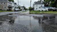
POCOMOKE CITY, Md. -- Over the next few years, officials want to fix every street and sidewalk within city limits. The city is ready to spend big bucks to solve a big problem. 

site-logo
  • Facebook
  • Twitter
  • LinkedIn
  • YouTube
  • Instagram

Sections

  • Latest Newscasts
  • Local News
  • Weather
  • Features
  • DelmarvaLife
  • Outdoors Delmarva
  • Delmarva Home Show
  • CoastTV
  • Telemundo Delmarva
  • Delmarva Sports Network
  • Video Center

Services

  • Search
  • Pay My Bill
  • Advertise With Us
  • Contact Us
  • Careers
  • Internships

Browser Compatibility

Your browser is out of date and potentially vulnerable to security risks.
We recommend switching to one of the following browsers:

Microsoft Edge Google Chrome Firefox
FCC Public File Applications & Related Materials EEO Public File Report FCC Closed Captioning Concerns Children's Programming Transparency Requirements for Group Health Plans
© Copyright 2025 WBOC TV 1729 N. Salisbury BLVD, Salisbury, MD  | Terms of Use  | Privacy Policy
Powered by BLOX Content Management System from BLOX Digital.