  • Facebook
  • Twitter
  • LinkedIn
  • YouTube
  • Instagram
  • Sign Up
  • Log In
  • Dashboard
  • Logout
    • My Account
    • Dashboard
    • Profile
    • Saved items
    • Logout
Home
  • About WBOC
  • Our Team
  • Programming
  • Contact Us
  • Careers
  • Internships
  • Policies
  • Report It
  • Get our newsletters
  • WBOC Apps
Pony Swim
News
  • Wicomico County
  • Worcester County
  • Somerset County
  • Dorchester County
  • Caroline County
  • Talbot County
  • Queen Annes County
  • Sussex County
  • Kent County
  • Accomack County
  • National News
  • International News
  • Latest Newscasts
  • Video Center
Weather
  • Forecast
  • Radar
  • Satellite
  • On The Waters
  • Weather Cameras
  • Closings
Delmarva Sports Network
Shows
  • DelmarvaLife
  • Outdoors Delmarva
  • Delmarva Home Show
Features
  • Travels With Charlie
  • Bless Our Children
  • Proud To Serve
  • The M Report
  • Heartbeat of Delmarva
  • Farming Our Future
  • Farm to Table Scholarship
  • Obituaries
  • Events: Shore Living Expo
Radio
  • 100.9% Classic Country WAAI
  • 107.1 The Duck
  • 102.5 WBOC FM
  • 93.5 The Beach
  • 107.7 BIG Classic Rock
  • 103.9 and 106.3 Coast Country
  • Watch Live
  • Apps
  • Contact Us
  • My Account
  • Sign Up
  • Log In
  • Dashboard
  • Logout
    • My Account
    • Dashboard
    • Profile
    • Saved items
    • Logout
  • Facebook
  • Twitter
  • LinkedIn
  • YouTube
  • Instagram
  • 93° Sunny
    • Salisbury, MD (21801)

      Today

      Thunderstorms. Storms may contain strong gusty winds. High 93F. Winds SSW at 10 to 15 mph. Chance of rain 100%..

      Tonight

      Thunderstorms, some locally heavy early will become more isolated after midnight. Low around 70F. Winds NNE at 5 to 10 mph. Chance of rain 100%.

      Updated: July 31, 2025 @ 2:01 pm

    • Full Forecast
site-logo
Watch Live

Newscast Schedule

View Programming Schedule
site-logo
  • 93°
  • Home
  • News
    • Local News
    • National News
    • International News
    • Latest Newscasts
    • Video Center
    • Wicomico County
    • Worcester County
    • Somerset County
    • Dorchester County
    • Caroline County
    • Talbot County
    • Queen Annes County
    • Sussex County
    • Kent County
    • Accomack County
    • Report It
  • Weather
    • Forecast
    • Radar
    • Satellite
    • On The Waters
    • Weather Cameras
    • Closings
  • Delmarva Sports Network
  • Shows
    • DelmarvaLife
    • Outdoors Delmarva
    • Delmarva Home Show
  • Features
    • Heartbeat of Delmarva
    • The M Report
    • Proud To Serve
    • Travels With Charlie
    • Farming Our Future
    • Farm to Table Scholarship
    • Jefferson Awards
    • Obituaries
    • Delmarva Experts
    • Bless Our Children
    • Events: Shore Living Expo
  • Radio
    • 100.9% Classic Country WAAI
    • 107.1 The Duck
    • 93.5 The Beach
    • 107.7 BIG Classic Rock
    • 103.9 and 106.3 Coast Country
    • 102.5 WBOC FM
  • Pony Swim
  • About Us
    • About WBOC
    • Our Team
    • Channel Finder
    • Apps
    • Contact Us
    • Get our newsletters
    • Careers
    • Internships
    • Policies
    • WBOC Solar Farm
Broadcast Schedule

On air schedule

Weather Alert

Weather Alert

THE NATIONAL WEATHER SERVICE HAS ISSUED SEVERE THUNDERSTORM WATCH
562 IN EFFECT UNTIL 8 PM EDT THIS EVENING FOR THE FOLLOWING AREAS

IN MARYLAND THIS WATCH INCLUDES 4 COUNTIES

IN SOUTHEAST MARYLAND

DORCHESTER            SOMERSET              WICOMICO
WORCESTER

IN VIRGINIA THIS WATCH INCLUDES 9 COUNTIES

IN CENTRAL VIRGINIA

FLUVANNA              GOOCHLAND             HANOVER
LOUISA

IN EAST CENTRAL VIRGINIA

ESSEX                 RICHMOND              WESTMORELAND

IN EASTERN VIRGINIA

NORTHUMBERLAND

IN NORTH CENTRAL VIRGINIA

CAROLINE

THIS INCLUDES THE CITIES OF BRAYS FORK, BURRUSS CORNER,
CAMBRIDGE, CARET, CEDAR FORK, CENTER CROSS, CHAMPLAIN,
COLONIAL BEACH, CORBIN, CRISFIELD, DAWN, DUNBROOKE, DUNNSVILLE,
GOOCHLAND, HOWERTONS, LAKE MONTICELLO, LEWISETTA, LOUISA,
MECHANICSVILLE, MINERAL, OCEAN CITY, PRINCESS ANNE, SALISBURY,
AND WARSAW.

Weather Alert

THE NATIONAL WEATHER SERVICE HAS ISSUED SEVERE THUNDERSTORM WATCH
562 IN EFFECT UNTIL 8 PM EDT THIS EVENING FOR THE FOLLOWING AREAS

THIS WATCH INCLUDES THE FOLLOWING ADJACENT COASTAL WATERS

CHESAPEAKE BAY NORTH OF POOLES ISLAND MD
CHESAPEAKE BAY FROM POOLES ISLAND TO SANDY POINT MD

CHESAPEAKE BAY FROM SANDY POINT TO NORTH BEACH MD

CHESAPEAKE BAY FROM NORTH BEACH TO DRUM POINT MD

CHESAPEAKE BAY FROM DRUM POINT MD TO SMITH POINT VA

TIDAL POTOMAC FROM KEY BRIDGE TO INDIAN HEAD MD

TIDAL POTOMAC FROM INDIAN HEAD TO COBB ISLAND MD

TIDAL POTOMAC FROM COBB ISLAND MD TO SMITH POINT VA

PATAPSCO RIVER INCLUDING BALTIMORE HARBOR
CHESTER RIVER TO QUEENSTOWN MD
EASTERN BAY
CHOPTANK RIVER TO CAMBRIDGE MD AND THE LITTLE CHOPTANK RIVER

PATUXENT RIVER TO BROOMES ISLAND MD
TANGIER SOUND AND THE INLAND WATERS SURROUNDING BLOODSWORTH
ISLAND

Weather Alert

...GUSTY SOUTH WINDS AND DEVELOPING THUNDERSTORMS...

Occasional southerly wind gusts to near 20 knots are possible this
afternoon. In addition, thunderstorms will develop and produce
gusty winds, heavy downpours and lightning strikes. Mariners
should prepare to seek safe harbor.

Weather Alert

...FLOOD WATCH REMAINS IN EFFECT THROUGH LATE TONIGHT...

* WHAT...Flooding caused by excessive rainfall continues to be
possible.

* WHERE...Portions of southeast Maryland, including the following
areas, Dorchester, Inland Worcester, Maryland Beaches, Somerset
and Wicomico and southeast Virginia, including the following area,
Accomack.

* WHEN...Through late tonight.

* IMPACTS...Excessive runoff may result in flooding of rivers,
creeks, streams, and other low-lying and flood-prone locations.
Flooding may occur in poor drainage and urban areas.

* ADDITIONAL DETAILS...
- A slow moving cold front approaches from the north later this
afternoon into tonight. Due to the humid airmass in place,
any showers or thunderstorms will have the potential to
produce locally heavy rainfall. Localized rainfall amounts of
2 to 4 inches are possible, with rainfall rates potentially
exceeding 2 inches per hour.
- http://www.weather.gov/safety/flood

PRECAUTIONARY/PREPAREDNESS ACTIONS...

You should monitor later forecasts and be alert for possible Flood
Warnings. Those living in areas prone to flooding should be prepared
to take action should flooding develop.

&&

Weather Alert

...SMALL CRAFT ADVISORY IN EFFECT FROM 6 AM FRIDAY TO MIDNIGHT
EDT SATURDAY NIGHT...

* WHAT...Northeast winds 10 to 15 kt with gusts up to 20 kt
expected.

* WHERE...Chesapeake Bay from Drum Point MD to Smith Point VA,
Tidal Potomac from Cobb Island MD to Smith Point VA, and
Tangier Sound and the inland waters surrounding Bloodsworth
Island.

* WHEN...From 6 AM Friday to midnight EDT Saturday night.

* IMPACTS...Conditions will be hazardous to small craft.

PRECAUTIONARY/PREPAREDNESS ACTIONS...

Inexperienced mariners, especially those operating smaller
vessels, should avoid navigating in hazardous conditions.

&&

eclipse


Advanced Search Close Search
From
To
Close Search
Chesapeake Bay Bridge-Tunnel: Chessie Finishes The Job
Latest News

Chesapeake Bay Bridge-Tunnel: Chessie Finishes The Job

  • Sean Curtis
  • Updated Jan 30, 2025

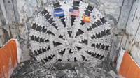
After a more than 6,300 foot journey, the tunnel boring machine nicknamed “Chessie” has fully completed its task of excavating what is planned to become a new expanse of the Chesapeake Bay Bridge-Tunnel (CBBT).

site-logo
  • Facebook
  • Twitter
  • LinkedIn
  • YouTube
  • Instagram

Sections

  • Latest Newscasts
  • Local News
  • Weather
  • Features
  • DelmarvaLife
  • Outdoors Delmarva
  • Delmarva Home Show
  • CoastTV
  • Telemundo Delmarva
  • Delmarva Sports Network
  • Video Center

Services

  • Search
  • Pay My Bill
  • Advertise With Us
  • Contact Us
  • Careers
  • Internships

Browser Compatibility

Your browser is out of date and potentially vulnerable to security risks.
We recommend switching to one of the following browsers:

Microsoft Edge Google Chrome Firefox
FCC Public File Applications & Related Materials EEO Public File Report FCC Closed Captioning Concerns Children's Programming Transparency Requirements for Group Health Plans
© Copyright 2025 WBOC TV 1729 N. Salisbury BLVD, Salisbury, MD  | Terms of Use  | Privacy Policy
Powered by BLOX Content Management System from BLOX Digital.