  • Facebook
  • Twitter
  • LinkedIn
  • YouTube
  • Instagram
  • Sign Up
  • Log In
  • Dashboard
  • Logout
    • My Account
    • Dashboard
    • Profile
    • Saved items
    • Logout
Home
  • About WBOC
  • Our Team
  • Programming
  • Contact Us
  • Careers
  • Internships
  • Policies
  • Report It
  • Get our newsletters
  • WBOC Apps
Spirits of the Shore
News
  • Wicomico County
  • Worcester County
  • Somerset County
  • Dorchester County
  • Caroline County
  • Talbot County
  • Queen Annes County
  • Sussex County
  • Kent County
  • Accomack County
  • National News
  • International News
  • Latest Newscasts
  • Video Center
Weather
  • Forecast
  • Radar
  • Satellite
  • On The Waters
  • Weather Cameras
  • Closings
Delmarva Sports Network
Shows
  • DelmarvaLife
  • Outdoors Delmarva
  • Delmarva Home Show
Features
  • Obituaries
  • Heartbeat of Delmarva
  • Proud To Serve
  • Back to School
  • The M Report
  • Farming Our Future
  • Farm to Table Scholarship
  • Bless Our Children
  • Events: Job Fair
Radio
  • 100.9% Classic Country WAAI
  • 107.1 The Duck
  • 102.5 WBOC FM
  • 93.5 The Beach
  • 107.7 BIG Classic Rock
  • 103.9 and 106.3 Coast Country
  • Watch Live
  • Apps
  • Contact Us
  • My Account
  • Sign Up
  • Log In
  • Dashboard
  • Logout
    • My Account
    • Dashboard
    • Profile
    • Saved items
    • Logout
  • Facebook
  • Twitter
  • LinkedIn
  • YouTube
  • Instagram
  • 61° Rain
    • Salisbury, MD (21801)

      Today

      Thunderstorms during the morning followed by a few showers this afternoon. Storms may contain strong gusty winds. High 69F. Winds SSE at 15 to 25 mph. Chance of rain 90%..

      Tonight

      A few passing clouds, otherwise generally clear. Low 49F. Winds WSW at 10 to 15 mph.

      Updated: October 30, 2025 @ 4:50 am

    • Full Forecast
site-logo
Watch Live

Newscast Schedule

View Programming Schedule
site-logo
  • 61°
  • Home
  • News
    • Wicomico County
    • Worcester County
    • Somerset County
    • Dorchester County
    • Caroline County
    • Talbot County
    • Queen Anne's County
    • Sussex County
    • Kent County
    • Accomack County
    • National News
    • International News
    • Latest Newscasts
    • Video Center
    • Report It
  • Weather
    • Forecast
    • Radar
    • Satellite
    • On The Waters
    • Weather Cameras
    • Closings
  • Delmarva Sports Network
  • Shows
    • DelmarvaLife
    • Outdoors Delmarva
    • Delmarva Home Show
  • Features
    • Spirits of the Shore
    • Obituaries
    • Heartbeat of Delmarva
    • Back to School
    • The M Report
    • Proud To Serve
    • Farming Our Future
    • Farm to Table Scholarship
    • Jefferson Awards
    • Delmarva Experts
    • Bless Our Children
    • Events: Job Fair
  • Radio
    • 100.9% Classic Country WAAI
    • 107.1 The Duck
    • 93.5 The Beach
    • 107.7 BIG Classic Rock
    • 103.9 and 106.3 Coast Country
    • 102.5 WBOC FM
  • About Us
    • About WBOC
    • Our Team
    • Channel Finder
    • Apps
    • Contact Us
    • Get our newsletters
    • Careers
    • Internships
    • Policies
    • WBOC Solar Farm
  • Report It
Broadcast Schedule

On air schedule

Weather Alert

Weather Alert

...SMALL CRAFT ADVISORY REMAINS IN EFFECT UNTIL 6 AM EDT FRIDAY...
...GALE WATCH REMAINS IN EFFECT FROM FRIDAY MORNING THROUGH
FRIDAY AFTERNOON...

* WHAT...For the Small Craft Advisory, east winds becoming
southwest 15 to 25 kt with gusts up to 30 kt and waves 2 to 4
ft. For the Gale Watch, west winds 15 to 25 kt with gusts up to
35 kt and waves 2 to 4 ft possible.

* WHERE...Chesapeake Bay main channel north of Smith Point VA,
Tidal Potomac from Cobb Island MD to Smith Point VA, Chester
River to Queenstown MD, Eastern Bay, Choptank River to
Cambridge MD and the Little Choptank River, Patuxent River to
Broomes Island MD, and Tangier Sound and the inland waters
surrounding Bloodsworth Island.

* WHEN...For the Small Craft Advisory, until 6 AM EDT Friday.
For the Gale Watch, from Friday morning through Friday
afternoon.

* IMPACTS...Strong winds can cause hazardous waves which could
capsize or damage vessels.

PRECAUTIONARY/PREPAREDNESS ACTIONS...

Mariners should consider altering plans to avoid possible
hazardous conditions.  Remain in port, seek safe harbor, alter
course, and/or secure the vessel for severe wind and waves.

&&

Weather Alert

...COASTAL FLOOD ADVISORY REMAINS IN EFFECT UNTIL 4 AM EDT EARLY
THIS MORNING...
...COASTAL FLOOD WARNING REMAINS IN EFFECT UNTIL 4 AM EDT
FRIDAY...

* WHAT...For the Coastal Flood Advisory, around one foot of
inundation above ground level in low-lying areas near shorelines
and tidal waterways. For the Coastal Flood Warning, two to three feet
of inundation above ground level expected in low-lying areas
near shorelines and tidal waterways.

* WHERE...Dorchester, Wicomico and Somerset Counties.

* WHEN...For the Coastal Flood Advisory, until 4 AM EDT early
this morning. For the Coastal Flood Warning, until 4 AM EDT
Friday.

* IMPACTS...Severe flooding will cause extensive inundation and
flooding of numerous roads and buildings resulting in a
significant threat to property and life. Water will be 2 to 3
feet or more above ground level in some areas. Severe flooding
will extend inland from the waterfront and shoreline flooding
homes, businesses and isolating some neighborhoods. Numerous
roads will be impassable under several feet of water and cars
submerged. Some areas will need to be evacuated.

PRECAUTIONARY/PREPAREDNESS ACTIONS...

Take the necessary actions to protect flood-prone property. If
travel is required, do not drive around barricades or through
water of unknown depth.

&&

Time of high total tides are approximate to the nearest hour.

CAMBRIDGE MD
MLLW CATEGORIES - MINOR 3.5 FT, MODERATE 4.0 FT, MAJOR 4.5 FT
MHHW CATEGORIES - MINOR 1.5 FT, MODERATE 2.0 FT, MAJOR 2.5 FT

TOTAL      TOTAL    DEPARTURE
DAY/TIME    TIDE       TIDE     FROM NORM   WAVES    FLOOD
FT MLLW    FT MHHW       FT       FT      IMPACT
--------  ---------  ---------  ---------  -------  --------
30/11 AM     4.4        2.4        2.7       1-2    MODERATE
31/12 AM     4.2        2.2        2.2       1-2    MODERATE
31/11 AM     3.6        1.6        1.9        2      MINOR
01/12 AM     2.9        0.9        0.9        2       NONE
01/01 PM     2.3        0.3        0.4        1       NONE
02/01 AM     2.0        0.0        0.0        1       NONE

BISHOPS HEAD MD
MLLW CATEGORIES - MINOR 3.2 FT, MODERATE 3.7 FT, MAJOR 4.2 FT
MHHW CATEGORIES - MINOR 1.1 FT, MODERATE 1.6 FT, MAJOR 2.1 FT

TOTAL      TOTAL    DEPARTURE
DAY/TIME    TIDE       TIDE     FROM NORM   WAVES    FLOOD
FT MLLW    FT MHHW       FT       FT      IMPACT
--------  ---------  ---------  ---------  -------  --------
30/08 AM     4.4        2.3        2.7       2-3     MAJOR
30/08 PM     4.4        2.3        2.5       2-3     MAJOR
31/09 AM     3.5        1.4        1.7       2-3     MINOR
31/10 PM     3.0        0.9        1.0       2-3      NONE
01/10 AM     2.6        0.5        0.6       1-2      NONE
01/10 PM     2.3        0.2        0.3        1       NONE

CRISFIELD MD
MLLW CATEGORIES - MINOR 3.5 FT, MODERATE 4.0 FT, MAJOR 5.0 FT
MHHW CATEGORIES - MINOR 1.3 FT, MODERATE 1.8 FT, MAJOR 2.8 FT

TOTAL      TOTAL    DEPARTURE
DAY/TIME    TIDE       TIDE     FROM NORM   WAVES    FLOOD
FT MLLW    FT MHHW       FT       FT      IMPACT
--------  ---------  ---------  ---------  -------  --------
30/07 AM     3.9        1.7        2.5        1      MINOR
30/08 PM     4.5        2.3        2.5        1     MODERATE
31/07 AM     3.8        1.6        2.4        1      MINOR
31/09 PM     3.2        1.0        1.2        1       NONE
01/10 AM     2.5        0.3        0.7        1       NONE
01/10 PM     2.3        0.1        0.3        1       NONE

&&

Weather Alert

...ISOLATED GALE FORCE GUSTS...

Isolated and brief easterly wind gusts up to 35 knots are possible
through the early morning hours on the Chesapeake Bay from Sandy
Point to Smith Point and the mouth of the Potomac River.
Inexperienced mariners in small craft should consider remaining in
harbor.

      Spirits of the Shore  
Advanced Search Close Search
From
To
Close Search
2:43
A Major Downtown Development In Salisbury Has Been Put On Hold
Latest News

A Major Downtown Development In Salisbury Has Been Put On Hold

  • Kyle Orens
  • Updated Jun 17, 2025

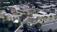
SALISBURY, Md. -- City of Salisbury staff have been directed to halt their review process of the Salisbury Town Center Apartments project. The…

2:20
Lawsuit Seeks to Halt Downtown Salisbury Parking Lot Development
Latest News

Lawsuit Seeks to Halt Downtown Salisbury Parking Lot Development

  • Sean Curtis, Hunter Landon
  • Updated May 23, 2025

The ongoing feud over downtown development in Salisbury is showing no signs of cooling with yet another lawsuit launched this week, this time against the City.

2:14
Salisbury Mayor and Developers Face-Off in Contentious Meeting
Latest News

Salisbury Mayor and Developers Face-Off in Contentious Meeting

  • Rachel Pierce
  • Updated May 20, 2025

Three developers claim Salisbury Mayor Randy Taylor has stalled development projects by his inaction to sign agreements the city of Salisbury previously committed to signing.

Salisbury Developer Reverses Plan to Shut Down Parking Lot
Latest News

Salisbury Developer Reverses Plan to Shut Down Parking Lot

  • Updated Nov 8, 2024

Developer Brad Gillis says he will no longer close a major parking lot in downtown Salisbury, which would have impacted those downtown. 

2:13
Salisbury Conflict May Impact Downtown Parking
Latest News

Salisbury Conflict May Impact Downtown Parking

  • Rachel Pierce
  • Updated Oct 18, 2024

A conflict between a developer and the city of Salisbury may put some in downtown Salisbury in a tough spot.

2:15
Wicomico County to Reconsider Tax Break for Developers
Latest News

Wicomico County to Reconsider Tax Break for Developers

  • Rachel Pierce
  • Updated Oct 16, 2024

The Wicomico County Council will discuss the possibility of removing or altering a tax credit for some developers.

site-logo
  • Facebook
  • Twitter
  • LinkedIn
  • YouTube
  • Instagram

Sections

  • Latest Newscasts
  • Local News
  • Weather
  • Features
  • DelmarvaLife
  • Outdoors Delmarva
  • Delmarva Home Show
  • CoastTV
  • Telemundo Delmarva
  • Delmarva Sports Network
  • Video Center

Services

  • Search
  • Pay My Bill
  • Advertise With Us
  • Contact Us
  • Careers
  • Internships

Browser Compatibility

Your browser is out of date and potentially vulnerable to security risks.
We recommend switching to one of the following browsers:

Microsoft Edge Google Chrome Firefox
FCC Public File Applications & Related Materials EEO Public File Report FCC Closed Captioning Concerns Children's Programming Transparency Requirements for Group Health Plans
© Copyright 2025 WBOC TV 1729 N. Salisbury BLVD, Salisbury, MD  | Terms of Use  | Privacy Policy
Powered by BLOX Content Management System from BLOX Digital.