


The Laurel School District has announced the reinstatement of Superintendent Dr. Shawn Larrimore following a DUI charge in May.
The Laurel School District has announced the reinstatement of Superintendent Dr. Shawn Larrimore following a DUI charge in May.
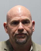
The Laurel Police Department has confirmed to WBOC the arrest of Laurel School District Superintendent Shawn Larrimore on DUI charges over the weekend.
