  • Facebook
  • Twitter
  • LinkedIn
  • YouTube
  • Instagram
  • Sign Up
  • Log In
  • Dashboard
  • Logout
    • My Account
    • Dashboard
    • Profile
    • Saved items
    • Logout
Home
  • About WBOC
  • Our Team
  • Programming
  • Contact Us
  • Careers
  • Internships
  • Policies
  • Report It
  • Get our newsletters
  • WBOC Apps
Spirits of the Shore
News
  • Wicomico County
  • Worcester County
  • Somerset County
  • Dorchester County
  • Caroline County
  • Talbot County
  • Queen Annes County
  • Sussex County
  • Kent County
  • Accomack County
  • National News
  • International News
  • Latest Newscasts
  • Video Center
Weather
  • Forecast
  • Radar
  • Satellite
  • On The Waters
  • Weather Cameras
  • Closings
Delmarva Sports Network
Shows
  • DelmarvaLife
  • Outdoors Delmarva
  • Delmarva Home Show
Features
  • Obituaries
  • Heartbeat of Delmarva
  • Proud To Serve
  • Back to School
  • The M Report
  • Farming Our Future
  • Farm to Table Scholarship
  • Bless Our Children
  • Events: Job Fair
Radio
  • 100.9% Classic Country WAAI
  • 107.1 The Duck
  • 102.5 WBOC FM
  • 93.5 The Beach
  • 107.7 BIG Classic Rock
  • 103.9 and 106.3 Coast Country
  • Watch Live
  • Apps
  • Contact Us
  • My Account
  • Sign Up
  • Log In
  • Dashboard
  • Logout
    • My Account
    • Dashboard
    • Profile
    • Saved items
    • Logout
  • Facebook
  • Twitter
  • LinkedIn
  • YouTube
  • Instagram
  • 56°
    • Salisbury, MD (21801)

      Today

      Light rain early...then remaining cloudy with thundershowers developing overnight. Low 54F. Winds E at 10 to 20 mph. Chance of rain 90%. Locally heavy rainfall possible..

      Tonight

      Light rain early...then remaining cloudy with thundershowers developing overnight. Low 54F. Winds E at 10 to 20 mph. Chance of rain 90%. Locally heavy rainfall possible.

      Updated: October 29, 2025 @ 3:47 pm

    • Full Forecast
site-logo
Watch Live

Newscast Schedule

View Programming Schedule
site-logo
  • 56°
  • Home
  • News
    • Wicomico County
    • Worcester County
    • Somerset County
    • Dorchester County
    • Caroline County
    • Talbot County
    • Queen Anne's County
    • Sussex County
    • Kent County
    • Accomack County
    • National News
    • International News
    • Latest Newscasts
    • Video Center
    • Report It
  • Weather
    • Forecast
    • Radar
    • Satellite
    • On The Waters
    • Weather Cameras
    • Closings
  • Delmarva Sports Network
  • Shows
    • DelmarvaLife
    • Outdoors Delmarva
    • Delmarva Home Show
  • Features
    • Spirits of the Shore
    • Obituaries
    • Heartbeat of Delmarva
    • Back to School
    • The M Report
    • Proud To Serve
    • Farming Our Future
    • Farm to Table Scholarship
    • Jefferson Awards
    • Delmarva Experts
    • Bless Our Children
    • Events: Job Fair
  • Radio
    • 100.9% Classic Country WAAI
    • 107.1 The Duck
    • 93.5 The Beach
    • 107.7 BIG Classic Rock
    • 103.9 and 106.3 Coast Country
    • 102.5 WBOC FM
  • About Us
    • About WBOC
    • Our Team
    • Channel Finder
    • Apps
    • Contact Us
    • Get our newsletters
    • Careers
    • Internships
    • Policies
    • WBOC Solar Farm
  • Report It
Broadcast Schedule

On air schedule

Weather Alert

Weather Alert

...COASTAL FLOOD ADVISORY REMAINS IN EFFECT UNTIL 4 AM EDT
THURSDAY...
...COASTAL FLOOD WARNING REMAINS IN EFFECT FROM 4 AM THURSDAY TO
4 AM EDT FRIDAY...

* WHAT...For the Coastal Flood Advisory, up to one foot of
inundation above ground level in low-lying areas near
shorelines and tidal waterways. For the Coastal Flood Warning,
around two feet of inundation above ground level expected in
low-lying areas near shorelines and tidal waterways.

* WHERE...Dorchester, Wicomico and Somerset Counties.

* WHEN...For the Coastal Flood Advisory, until 4 AM EDT
Thursday. For the Coastal Flood Warning, from 4 AM Thursday to
4 AM EDT Friday.

* IMPACTS...Widespread flooding of vulnerable areas will result
in an elevated threat of property damage to homes and
businesses near the waterfront and shoreline. Water will be
around 2 feet above ground level in some areas resulting in a
sufficient depth to close numerous roads and threaten homes
and businesses. Flooding will extend inland from the
waterfront along tidal rivers and bays resulting in some road
closures and flooding of vehicles.

PRECAUTIONARY/PREPAREDNESS ACTIONS...

Take the necessary actions to protect flood-prone property. If
travel is required, do not drive around barricades or through
water of unknown depth.

&&

Time of high total tides are approximate to the nearest hour.

CAMBRIDGE MD
MLLW CATEGORIES - MINOR 3.5 FT, MODERATE 4.0 FT, MAJOR 4.5 FT
MHHW CATEGORIES - MINOR 1.5 FT, MODERATE 2.0 FT, MAJOR 2.5 FT

TOTAL      TOTAL    DEPARTURE
DAY/TIME    TIDE       TIDE     FROM NORM   WAVES    FLOOD
FT MLLW    FT MHHW       FT       FT      IMPACT
--------  ---------  ---------  ---------  -------  --------
29/10 PM     3.6        1.6        1.7        1      MINOR
30/11 AM     4.1        2.1        2.4        1     MODERATE
31/12 AM     4.3        2.3        2.3        1     MODERATE
31/11 AM     3.6        1.6        1.9        2      MINOR
01/12 AM     3.0        1.0        1.0       1-2      NONE

BISHOPS HEAD MD
MLLW CATEGORIES - MINOR 3.2 FT, MODERATE 3.7 FT, MAJOR 4.2 FT
MHHW CATEGORIES - MINOR 1.1 FT, MODERATE 1.6 FT, MAJOR 2.1 FT

TOTAL      TOTAL    DEPARTURE
DAY/TIME    TIDE       TIDE     FROM NORM   WAVES    FLOOD
FT MLLW    FT MHHW       FT       FT      IMPACT
--------  ---------  ---------  ---------  -------  --------
29/08 PM     3.6        1.5        1.7        2      MINOR
30/08 AM     4.2        2.1        2.5        2      MAJOR
30/08 PM     4.3        2.2        2.4        2      MAJOR
31/09 AM     3.6        1.5        1.8       2-3     MINOR
31/09 PM     3.1        1.0        1.2        2       NONE
01/10 AM     2.6        0.5        0.6        2       NONE

CRISFIELD MD
MLLW CATEGORIES - MINOR 3.5 FT, MODERATE 4.0 FT, MAJOR 5.0 FT
MHHW CATEGORIES - MINOR 1.3 FT, MODERATE 1.8 FT, MAJOR 2.8 FT

TOTAL      TOTAL    DEPARTURE
DAY/TIME    TIDE       TIDE     FROM NORM   WAVES    FLOOD
FT MLLW    FT MHHW       FT       FT      IMPACT
--------  ---------  ---------  ---------  -------  --------
29/07 PM     3.7        1.5        1.7        1      MINOR
30/08 AM     3.8        1.6        2.3        1      MINOR
30/08 PM     4.5        2.3        2.5        1     MODERATE
31/08 AM     3.9        1.7        2.3        1      MINOR
31/09 PM     3.4        1.2        1.4        1       NONE
01/09 AM     2.5        0.3        0.8        1       NONE

&&

Weather Alert

...SMALL CRAFT ADVISORY NOW IN EFFECT UNTIL 6 AM EDT FRIDAY...
...GALE WATCH IN EFFECT FROM FRIDAY MORNING THROUGH FRIDAY
AFTERNOON...

* WHAT...For the Small Craft Advisory, east winds through Thursday
morning becoming south by Thursday afternoon 15 to 25 kt with
gusts up to 30 kt and waves 2 to 4 ft, highest early Thursday
morning. Winds will become west Thursday night. For the Gale
Watch, west winds 15 to 25 kt with gusts up to 35 kt possible.

* WHERE...Chesapeake Bay main channel north of Smith Point VA,
Tidal Potomac from Cobb Island MD to Smith Point VA, Chester
River to Queenstown MD, Eastern Bay, Choptank River to
Cambridge MD and the Little Choptank River, Patuxent River to
Broomes Island MD, and Tangier Sound and the inland waters
surrounding Bloodsworth Island.

* WHEN...For the Small Craft Advisory, until 6 AM EDT Friday.
For the Gale Watch, from Friday morning through Friday
afternoon.

* IMPACTS...Strong winds can cause hazardous waves which could
capsize or damage vessels.

PRECAUTIONARY/PREPAREDNESS ACTIONS...

Mariners should consider altering plans to avoid possible
hazardous conditions.  Remain in port, seek safe harbor, alter
course, and/or secure the vessel for severe wind and waves.

&&

      Spirits of the Shore  
Advanced Search Close Search
From
To
Close Search
2:12
Neighbors chime in as Milford city leaders analyze development and growth trends
Latest News

Neighbors chime in as Milford city leaders analyze development and growth trends

  • Maegan Summers
  • Updated Sep 25, 2025

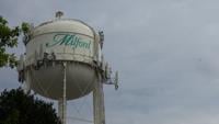
Data recently put together by Milford city leaders shows the city is looking at decades of population and development growth.

2:45
Fresh Delaware Faces City Bans Blocking Recreational Cannabis Sales
Latest News

Fresh Delaware Faces City Bans Blocking Recreational Cannabis Sales

  • Tiffani Amber
  • Updated Aug 8, 2025

Although it has been one week since Delaware's adult-use recreational cannabis market officially opened, Fresh Delaware says two of its three locations have been unable to participate due to city bans on recreational marijuana sales.

+2
Milford Introduces New City Manager
Latest News

Milford Introduces New City Manager

  • Sean Curtis
  • Updated Jun 2, 2025

City of Milford officials have announced the appointment of Christopher Coleman as their next City Manager.

Milford City Leaders to Continue Discussion on Deep Branch Park
Latest News

Milford City Leaders to Continue Discussion on Deep Branch Park

  • Maegan Summers
  • Apr 13, 2025

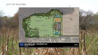
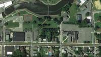
City leaders are expected to continue discussing the proposed Deep BranchPark at their council meeting on Monday, April 14th. The discussion will include a look at new site plans for the project. 

Construction Delays Milford Memorial Park Upgrades
Latest News

Construction Delays Milford Memorial Park Upgrades

  • Bees Beesley
  • Sep 6, 2023

The City of Milford Parks & Recreation Department today announced construction delays pushing back the completion of the Milford Memorial Park. 

Fur Baby
Delmarvalife

Fur Baby

  • By Lisa Bryant
  • Dec 17, 2021
Paid Content by Fur Baby Pet Resort – Top Notch Pet Care and Pet Goods
Delmarvalife

Paid Content by Fur Baby Pet Resort – Top Notch Pet Care and Pet Goods

  • By Lisa Bryant
  • Dec 17, 2021

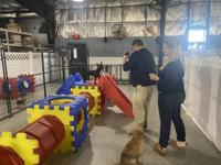
Lisa takes us to Fur Baby Pet Resort who’s celebrating ten years of service.

site-logo
  • Facebook
  • Twitter
  • LinkedIn
  • YouTube
  • Instagram

Sections

  • Latest Newscasts
  • Local News
  • Weather
  • Features
  • DelmarvaLife
  • Outdoors Delmarva
  • Delmarva Home Show
  • CoastTV
  • Telemundo Delmarva
  • Delmarva Sports Network
  • Video Center

Services

  • Search
  • Pay My Bill
  • Advertise With Us
  • Contact Us
  • Careers
  • Internships

Browser Compatibility

Your browser is out of date and potentially vulnerable to security risks.
We recommend switching to one of the following browsers:

Microsoft Edge Google Chrome Firefox
FCC Public File Applications & Related Materials EEO Public File Report FCC Closed Captioning Concerns Children's Programming Transparency Requirements for Group Health Plans
© Copyright 2025 WBOC TV 1729 N. Salisbury BLVD, Salisbury, MD  | Terms of Use  | Privacy Policy
Powered by BLOX Content Management System from BLOX Digital.