  • Facebook
  • Twitter
  • LinkedIn
  • YouTube
  • Instagram
  • Sign Up
  • Log In
  • Dashboard
  • Logout
    • My Account
    • Dashboard
    • Profile
    • Saved items
    • Logout
Home
  • About WBOC
  • Our Team
  • Programming
  • Contact Us
  • Careers
  • Internships
  • Policies
  • Report It
  • Get our newsletters
  • WBOC Apps
Spirits of the Shore
News
  • Wicomico County
  • Worcester County
  • Somerset County
  • Dorchester County
  • Caroline County
  • Talbot County
  • Queen Annes County
  • Sussex County
  • Kent County
  • Accomack County
  • National News
  • International News
  • Latest Newscasts
  • Video Center
Weather
  • Forecast
  • Radar
  • Satellite
  • On The Waters
  • Weather Cameras
  • Closings
Delmarva Sports Network
Shows
  • DelmarvaLife
  • Outdoors Delmarva
  • Delmarva Home Show
Features
  • Obituaries
  • Heartbeat of Delmarva
  • Proud To Serve
  • Back to School
  • The M Report
  • Farming Our Future
  • Farm to Table Scholarship
  • Bless Our Children
  • Events: Job Fair
Radio
  • 100.9% Classic Country WAAI
  • 107.1 The Duck
  • 102.5 WBOC FM
  • 93.5 The Beach
  • 107.7 BIG Classic Rock
  • 103.9 and 106.3 Coast Country
  • Watch Live
  • Apps
  • Contact Us
  • My Account
  • Sign Up
  • Log In
  • Dashboard
  • Logout
    • My Account
    • Dashboard
    • Profile
    • Saved items
    • Logout
  • Facebook
  • Twitter
  • LinkedIn
  • YouTube
  • Instagram
  • 60° Rain
    • Salisbury, MD (21801)

      Today

      Thunderstorms in the morning will give way to partly cloudy skies late. Storms may contain strong gusty winds. High 69F. Winds S at 10 to 20 mph. Chance of rain 100%..

      Tonight

      Mostly clear skies. Low 49F. Winds WSW at 10 to 15 mph.

      Updated: October 30, 2025 @ 2:50 am

    • Full Forecast
site-logo
Watch Live

Newscast Schedule

View Programming Schedule
site-logo
  • 60°
  • Home
  • News
    • Wicomico County
    • Worcester County
    • Somerset County
    • Dorchester County
    • Caroline County
    • Talbot County
    • Queen Anne's County
    • Sussex County
    • Kent County
    • Accomack County
    • National News
    • International News
    • Latest Newscasts
    • Video Center
    • Report It
  • Weather
    • Forecast
    • Radar
    • Satellite
    • On The Waters
    • Weather Cameras
    • Closings
  • Delmarva Sports Network
  • Shows
    • DelmarvaLife
    • Outdoors Delmarva
    • Delmarva Home Show
  • Features
    • Spirits of the Shore
    • Obituaries
    • Heartbeat of Delmarva
    • Back to School
    • The M Report
    • Proud To Serve
    • Farming Our Future
    • Farm to Table Scholarship
    • Jefferson Awards
    • Delmarva Experts
    • Bless Our Children
    • Events: Job Fair
  • Radio
    • 100.9% Classic Country WAAI
    • 107.1 The Duck
    • 93.5 The Beach
    • 107.7 BIG Classic Rock
    • 103.9 and 106.3 Coast Country
    • 102.5 WBOC FM
  • About Us
    • About WBOC
    • Our Team
    • Channel Finder
    • Apps
    • Contact Us
    • Get our newsletters
    • Careers
    • Internships
    • Policies
    • WBOC Solar Farm
  • Report It
Broadcast Schedule

On air schedule

Weather Alert

Weather Alert

...ISOLATED GALE FORCE GUSTS...

Isolated and brief easterly wind gusts up to 35 knots are possible
through the early morning hours on the Chesapeake Bay from Sandy
Point to Smith Point and the mouth of the Potomac River.
Inexperienced mariners in small craft should consider remaining in
harbor.

Weather Alert

...SMALL CRAFT ADVISORY REMAINS IN EFFECT UNTIL 6 AM EDT FRIDAY...
...GALE WATCH REMAINS IN EFFECT FROM FRIDAY MORNING THROUGH
FRIDAY AFTERNOON...

* WHAT...For the Small Craft Advisory, south winds 15 to 25 kt
with gusts up to 30 kt and waves 2 to 4 ft. For the Gale
Watch, west winds 15 to 25 kt with gusts up to 35 kt and waves
2 to 4 ft possible.

* WHERE...Chesapeake Bay main channel north of Smith Point VA,
Tidal Potomac from Cobb Island MD to Smith Point VA, Chester
River to Queenstown MD, Eastern Bay, Choptank River to
Cambridge MD and the Little Choptank River, Patuxent River to
Broomes Island MD, and Tangier Sound and the inland waters
surrounding Bloodsworth Island.

* WHEN...For the Small Craft Advisory, until 6 AM EDT Friday.
For the Gale Watch, from Friday morning through Friday
afternoon.

* IMPACTS...Strong winds can cause hazardous waves which could
capsize or damage vessels.

PRECAUTIONARY/PREPAREDNESS ACTIONS...

Mariners should consider altering plans to avoid possible
hazardous conditions.  Remain in port, seek safe harbor, alter
course, and/or secure the vessel for severe wind and waves.

&&

Weather Alert

...COASTAL FLOOD ADVISORY REMAINS IN EFFECT UNTIL 4 AM EDT
THURSDAY...
...COASTAL FLOOD WARNING REMAINS IN EFFECT FROM 4 AM THURSDAY TO
4 AM EDT FRIDAY...

* WHAT...For the Coastal Flood Advisory, around one foot of
inundation above ground level in low-lying areas near
shorelines and tidal waterways. For the Coastal Flood Warning,
around two feet of inundation above ground level expected in
low-lying areas near shorelines and tidal waterways.

* WHERE...Dorchester, Wicomico and Somerset Counties.

* WHEN...For the Coastal Flood Advisory, until 4 AM EDT
Thursday. For the Coastal Flood Warning, from 4 AM Thursday to
4 AM EDT Friday.

* IMPACTS...Widespread flooding of vulnerable areas will result
in an elevated threat of property damage to homes and
businesses near the waterfront and shoreline. Water will be
around 2 feet above ground level in some areas resulting in a
sufficient depth to close numerous roads and threaten homes
and businesses. Flooding will extend inland from the
waterfront along tidal rivers and bays resulting in some road
closures and flooding of vehicles.

PRECAUTIONARY/PREPAREDNESS ACTIONS...

Take the necessary actions to protect flood-prone property. If
travel is required, do not drive around barricades or through
water of unknown depth.

&&

Time of high total tides are approximate to the nearest hour.

CAMBRIDGE MD
MLLW CATEGORIES - MINOR 3.5 FT, MODERATE 4.0 FT, MAJOR 4.5 FT
MHHW CATEGORIES - MINOR 1.5 FT, MODERATE 2.0 FT, MAJOR 2.5 FT

TOTAL      TOTAL    DEPARTURE
DAY/TIME    TIDE       TIDE     FROM NORM   WAVES    FLOOD
FT MLLW    FT MHHW       FT       FT      IMPACT
--------  ---------  ---------  ---------  -------  --------
29/10 PM     3.6        1.6        1.7        1      MINOR
30/11 AM     4.3        2.3        2.6        1     MODERATE
31/12 AM     4.2        2.2        2.2       1-2    MODERATE
31/11 AM     3.6        1.6        1.9        2      MINOR
01/12 AM     2.9        0.9        0.9       1-2      NONE
01/01 PM     2.3        0.3        0.4        1       NONE

BISHOPS HEAD MD
MLLW CATEGORIES - MINOR 3.2 FT, MODERATE 3.7 FT, MAJOR 4.2 FT
MHHW CATEGORIES - MINOR 1.1 FT, MODERATE 1.6 FT, MAJOR 2.1 FT

TOTAL      TOTAL    DEPARTURE
DAY/TIME    TIDE       TIDE     FROM NORM   WAVES    FLOOD
FT MLLW    FT MHHW       FT       FT      IMPACT
--------  ---------  ---------  ---------  -------  --------
29/09 PM     3.7        1.6        1.9        2     MODERATE
30/09 AM     4.3        2.2        2.6        2      MAJOR
30/08 PM     4.4        2.3        2.5       2-3     MAJOR
31/09 AM     3.5        1.4        1.7        3      MINOR
31/10 PM     3.0        0.9        1.0        3       NONE
01/10 AM     2.6        0.5        0.6        2       NONE

CRISFIELD MD
MLLW CATEGORIES - MINOR 3.5 FT, MODERATE 4.0 FT, MAJOR 5.0 FT
MHHW CATEGORIES - MINOR 1.3 FT, MODERATE 1.8 FT, MAJOR 2.8 FT

TOTAL      TOTAL    DEPARTURE
DAY/TIME    TIDE       TIDE     FROM NORM   WAVES    FLOOD
FT MLLW    FT MHHW       FT       FT      IMPACT
--------  ---------  ---------  ---------  -------  --------
30/08 AM     3.9        1.7        2.4        1      MINOR
30/08 PM     4.5        2.3        2.5        1     MODERATE
31/08 AM     3.8        1.6        2.2        1      MINOR
31/09 PM     3.2        1.0        1.2        1       NONE
01/10 AM     2.5        0.3        0.7        1       NONE

&&

      Spirits of the Shore  
Advanced Search Close Search
From
To
Close Search
2:57
Wicomico County Schools consider $6 million plan for weapons detection systems
Latest News

Wicomico County Schools consider $6 million plan for weapons detection systems

  • Updated Oct 6, 2025

Wicomico County Public Schools is weighing a multi-million-dollar investment to enhance safety across the district. School leaders are explori…

1:53
Weapon detectors implemented at two Sussex County High Schools
Latest News

Weapon detectors implemented at two Sussex County High Schools

  • Updated Sep 15, 2025

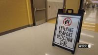
Two Sussex County high schools have implemented weapon detectors as an additional security measure. Students Sussex Central High School and In…

2:34
Seaford School District to Require Clear Backpacks Amid New Security Measures
Latest News

Seaford School District to Require Clear Backpacks Amid New Security Measures

  • Jack Ford
  • Updated Jun 19, 2024

The Seaford School District has announced new security measures, including the requirement for students in grades 6-12 to use clear backpacks and the purchase of additional weapon detection systems.

Free Smoke Detectors Aim to Cut Fire Related Deaths in Delaware
Latest News

Free Smoke Detectors Aim to Cut Fire Related Deaths in Delaware

  • Jana Ruark
  • Updated Jan 16, 2024

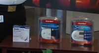
Delaware is looking to tackle fire deaths with more smoke detectors.

2:08
Seaford Schools Enhance Security with Weapons Detectors
Latest News

Seaford Schools Enhance Security with Weapons Detectors

  • Updated Oct 23, 2023

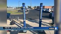
Some Sussex County schools are expanding their security protocols. The Seaford School District recently announced it acquired OpenGate Weapons…

2:05
New Technology has Made its way Into Accomack County Schools
Latest News

New Technology has Made its way Into Accomack County Schools

  • Updated Aug 30, 2023

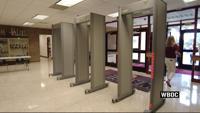
New metal detectors have been placed at all student entrances at every school. The Accomack County School Board said this is about being proac…

1:52
New Security Measures at the Delaware State Fair
Latest News

New Security Measures at the Delaware State Fair

  • Updated Jul 20, 2023

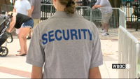
The Delaware State Fair opened its gates at noon on Thursday, But before visitors can step into the fun of the fair they firsts have to step t…

Detectors
Delmarvalife

Detectors

  • By Lauren Hitch
  • Updated Jun 13, 2023
Different Detectors to Have in Your Home – Smoke, Carbon Monoxide, & Explosive Gas
Delmarvalife

Different Detectors to Have in Your Home – Smoke, Carbon Monoxide, & Explosive Gas

  • By DelmarvaLife Staff
  • Updated Jun 13, 2023

Just last year, a Somerset County father and his seven children tragically died from accidental carbon monoxide poisoning at their […]

carbon_monoxide_6_17_15
Delmarvalife

carbon_monoxide_6_17_15

  • By Laura Landry
  • Updated Jun 13, 2023
  •  
  • 1 of 2
  •  
site-logo
  • Facebook
  • Twitter
  • LinkedIn
  • YouTube
  • Instagram

Sections

  • Latest Newscasts
  • Local News
  • Weather
  • Features
  • DelmarvaLife
  • Outdoors Delmarva
  • Delmarva Home Show
  • CoastTV
  • Telemundo Delmarva
  • Delmarva Sports Network
  • Video Center

Services

  • Search
  • Pay My Bill
  • Advertise With Us
  • Contact Us
  • Careers
  • Internships

Browser Compatibility

Your browser is out of date and potentially vulnerable to security risks.
We recommend switching to one of the following browsers:

Microsoft Edge Google Chrome Firefox
FCC Public File Applications & Related Materials EEO Public File Report FCC Closed Captioning Concerns Children's Programming Transparency Requirements for Group Health Plans
© Copyright 2025 WBOC TV 1729 N. Salisbury BLVD, Salisbury, MD  | Terms of Use  | Privacy Policy
Powered by BLOX Content Management System from BLOX Digital.