  • Facebook
  • Twitter
  • LinkedIn
  • YouTube
  • Instagram
  • Sign Up
  • Log In
  • Dashboard
  • Logout
    • My Account
    • Dashboard
    • Profile
    • Saved items
    • Logout
Home
  • About WBOC
  • Our Team
  • Programming
  • Contact Us
  • Careers
  • Internships
  • Policies
  • Report It
  • Get our newsletters
  • WBOC Apps
News
  • Wicomico County
  • Worcester County
  • Somerset County
  • Dorchester County
  • Caroline County
  • Talbot County
  • Queen Annes County
  • Sussex County
  • Kent County
  • Accomack County
  • National News
  • International News
  • Latest Newscasts
  • Video Center
Weather
  • Forecast
  • Radar
  • Satellite
  • On The Waters
  • Weather Cameras
  • Closings
Delmarva Sports Network
Shows
  • DelmarvaLife
  • Outdoors Delmarva
  • Delmarva Home Show
Features
  • Obituaries
  • Heartbeat of Delmarva
  • Proud To Serve
  • The M Report
  • Farming Our Future
  • Farm to Table Scholarship
  • Bless Our Children
  • Events: Shore Living Expo
Radio
  • 100.9% Classic Country WAAI
  • 107.1 The Duck
  • 102.5 WBOC FM
  • 93.5 The Beach
  • 107.7 BIG Classic Rock
  • 103.9 and 106.3 Coast Country
  • Watch Live
  • Apps
  • Contact Us
  • My Account
  • Sign Up
  • Log In
  • Dashboard
  • Logout
    • My Account
    • Dashboard
    • Profile
    • Saved items
    • Logout
  • Facebook
  • Twitter
  • LinkedIn
  • YouTube
  • Instagram
  • 62° Clear
    • Salisbury, MD (21801)

      Today

      Abundant sunshine. High near 80F. Winds NNE at 5 to 10 mph..

      Tonight

      A clear sky. Low 57F. Winds light and variable.

      Updated: August 22, 2025 @ 3:39 am

    • Full Forecast
site-logo
Watch Live

Newscast Schedule

View Programming Schedule
site-logo
  • 62°
  • Home
  • News
    • Wicomico County
    • Worcester County
    • Somerset County
    • Dorchester County
    • Caroline County
    • Talbot County
    • Queen Annes County
    • Sussex County
    • Kent County
    • Accomack County
    • National News
    • International News
    • Latest Newscasts
    • Video Center
    • Report It
  • Weather
    • Forecast
    • Radar
    • Satellite
    • On The Waters
    • Weather Cameras
    • Closings
  • Delmarva Sports Network
  • Shows
    • DelmarvaLife
    • Outdoors Delmarva
    • Delmarva Home Show
  • Features
    • Obituaries
    • Heartbeat of Delmarva
    • The M Report
    • Proud To Serve
    • Farming Our Future
    • Farm to Table Scholarship
    • Jefferson Awards
    • Delmarva Experts
    • Bless Our Children
    • Events: Shore Living Expo
  • Radio
    • 100.9% Classic Country WAAI
    • 107.1 The Duck
    • 93.5 The Beach
    • 107.7 BIG Classic Rock
    • 103.9 and 106.3 Coast Country
    • 102.5 WBOC FM
  • About Us
    • About WBOC
    • Our Team
    • Channel Finder
    • Apps
    • Contact Us
    • Get our newsletters
    • Careers
    • Internships
    • Policies
    • WBOC Solar Farm
Broadcast Schedule

On air schedule

Weather Alert

Weather Alert

...SMALL CRAFT ADVISORY REMAINS IN EFFECT UNTIL 6 AM EDT EARLY
THIS MORNING...

* WHAT...North winds 10 to 15 kt with gusts up to 20 kt.

* WHERE...Chesapeake Bay from Drum Point MD to Smith Point VA,
Tidal Potomac from Cobb Island MD to Smith Point VA and
Tangier Sound and the inland waters surrounding Bloodsworth
Island.

* WHEN...Until 6 AM EDT early this morning.

* IMPACTS...Conditions will be hazardous to small craft.

PRECAUTIONARY/PREPAREDNESS ACTIONS...

Inexperienced mariners, especially those operating smaller
vessels, should avoid navigating in hazardous conditions.

&&

Weather Alert

...COASTAL FLOOD ADVISORY REMAINS IN EFFECT UNTIL NOON EDT
TODAY...
...COASTAL FLOOD WARNING REMAINS IN EFFECT FROM NOON TODAY TO
8 PM EDT SATURDAY...

* WHAT...For the Coastal Flood Advisory, up to one half foot of
inundation above ground level in low-lying areas near
shorelines and tidal waterways. For the Coastal Flood Warning,
one to two feet of inundation above ground level expected in
low-lying areas near shorelines and tidal waterways.

* WHERE...Dorchester, Wicomico and Somerset Counties.

* WHEN...For the Coastal Flood Advisory, until noon EDT today.
For the Coastal Flood Warning, from noon today to 8 PM EDT
Saturday.

* IMPACTS...Widespread flooding of vulnerable areas will result
in an elevated threat of property damage to homes and businesses
near the waterfront and shoreline. Water will be 1 to 2 feet
above ground level in some areas resulting in a sufficient depth
to close numerous roads and threaten homes and businesses.
Flooding will extend inland from the waterfront along tidal
rivers and bays resulting in some road closures and flooding of
vehicles.

PRECAUTIONARY/PREPAREDNESS ACTIONS...

Take the necessary actions to protect flood-prone property. If
travel is required, do not drive around barricades or through
water of unknown depth.

&&

Time of high total tides are approximate to the nearest hour.

CAMBRIDGE MD
MLLW CATEGORIES - MINOR 3.5 FT, MODERATE 4.0 FT, MAJOR 4.5 FT
MHHW CATEGORIES - MINOR 1.5 FT, MODERATE 2.0 FT, MAJOR 2.5 FT

TOTAL      TOTAL    DEPARTURE
DAY/TIME    TIDE       TIDE     FROM NORM   WAVES    FLOOD
FT MLLW    FT MHHW       FT       FT      IMPACT
--------  ---------  ---------  ---------  -------  --------
22/04 AM     3.5        1.5        1.2        1      MINOR
22/04 PM     3.7        1.7        1.7        1      MINOR
23/04 AM     4.1        2.1        1.8        1     MODERATE
23/05 PM     3.7        1.7        1.6        1      MINOR
24/05 AM     3.9        1.9        1.6        1      MINOR
24/05 PM     3.3        1.3        1.3        1       NONE

BISHOPS HEAD MD
MLLW CATEGORIES - MINOR 3.2 FT, MODERATE 3.7 FT, MAJOR 4.2 FT
MHHW CATEGORIES - MINOR 1.1 FT, MODERATE 1.6 FT, MAJOR 2.1 FT

TOTAL      TOTAL    DEPARTURE
DAY/TIME    TIDE       TIDE     FROM NORM   WAVES    FLOOD
FT MLLW    FT MHHW       FT       FT      IMPACT
--------  ---------  ---------  ---------  -------  --------
22/01 PM     3.9        1.8        1.7       1-2    MODERATE
23/02 AM     4.3        2.2        1.9        1      MAJOR
23/02 PM     3.9        1.8        1.7        1     MODERATE
24/03 AM     4.1        2.0        1.7        1     MODERATE
24/03 PM     3.7        1.6        1.4       1-2    MODERATE

CRISFIELD MD
MLLW CATEGORIES - MINOR 3.5 FT, MODERATE 4.0 FT, MAJOR 5.0 FT
MHHW CATEGORIES - MINOR 1.3 FT, MODERATE 1.8 FT, MAJOR 2.8 FT

TOTAL      TOTAL    DEPARTURE
DAY/TIME    TIDE       TIDE     FROM NORM   WAVES    FLOOD
FT MLLW    FT MHHW       FT       FT      IMPACT
--------  ---------  ---------  ---------  -------  --------
22/01 PM     3.7        1.5        2.1        1      MINOR
23/01 AM     4.3        2.1        2.1        1     MODERATE
23/01 PM     3.5        1.3        1.8        1      MINOR
24/01 AM     3.8        1.6        1.7        1      MINOR
24/02 PM     3.3        1.1        1.5        1       NONE

&&

Weather Alert

This product covers CENTRAL AND EASTERN VIRGINIA...NORTHEAST NORTH CAROLINA...AND THE LOWER MARYLAND EASTERN SHORE

**ERIN MOVING AWAY FROM THE NORTH CAROLINA COAST**

NEW INFORMATION
---------------

* CHANGES TO WATCHES AND WARNINGS:
- All watches and warnings have been canceled

* CURRENT WATCHES AND WARNINGS:
- None

* STORM INFORMATION:
- About 390 miles east-southeast of Ocean City MD or about 440
miles east of Norfolk VA
- 36.8N 68.2W
- Storm Intensity 100 mph
- Movement Northeast or 50 degrees at 20 mph

SITUATION OVERVIEW
------------------

Hurricane Erin, currently about 420 miles ENE of Cape Hatteras, NC,
continues to move northeast away from the coast. Erin will continue to
move northeastward with the center of the storm tracking well offshore
of the Mid-Atlantic coast. The tropical storm force wind threat has
come to an end for the local area with Erin moving further away.

Erin will continue to bring high surf, significant dune and beach
erosion and moderate to locally major tidal flooding to the area. Seas
of 12 to 18 feet over the coastal waters remain possible this evening
into tonight which will allow for significant beach and dune erosion
for the coast especially around the times of high tide. In addition,
moderate to locally major coastal flooding is expected during the high
tide cycle this evening and tonight with inundation of 1 to 3 feet
above normally high ground. A Coastal Flood Warning remains in effect
for the Atlantic coast from Corolla, NC to Ocean City, MD, areas
adjacent to the Chesapeake Bay from Windmill Point south, tidal
portions of the James, York, and Rappahannock Rivers as well as
adjacent estuaries. A Coastal Flood Warning is also in effect for
areas adjacent to the Chesapeake Bay north of Windmill Point through
the bay side of the lower Maryland Eastern Shore, and the southern
shore of the Potomac River, as well as adjacent estuaries.

POTENTIAL IMPACTS
-----------------

* SURGE:
A Coastal Flood Warning remains in effect for areas along the Atlantic
coast, Chesapeake Bay, and tidal rivers.

* OTHER COASTAL HAZARDS:
Along the Atlantic coast from Fenwick Island Delaware to Duck North
Carolina, expect waves to build to 12 to 18 ft today. These large
waves combined with increased water levels will likely allow for
significant beach and dune erosion. There is a high risk of rip
currents along the shoreline through Friday, and a high risk of rip
currents will likely continue into the weekend.

* WIND:
Little to no additional impacts are anticipated at this time.

PRECAUTIONARY/PREPAREDNESS ACTIONS
----------------------------------

* EVACUATIONS:

Follow the advice of local officials.

* OTHER PREPAREDNESS INFORMATION:

If you are prone to coastal flooding or ocean overwash be prepared for
the possibility of a quick rise in water levels.

Closely monitor weather.gov, NOAA Weather Radio and local news outlets
for official storm information. Listen for possible changes to the
forecast.

* ADDITIONAL SOURCES OF INFORMATION:
- For information on appropriate preparations see
www.readyvirginia.gov, readync.org or mema.maryland.gov
- For the latest weather and storm information go to
weather.gov/wakefield

NEXT UPDATE
-----------

As it pertains to this event...this will be the last local statement
issued by the National Weather Service in Wakefield VA regarding the
effects of tropical cyclone hazards upon the area.

eclipse


Closings

Click here to view closings and delays

Advanced Search Close Search
From
To
Close Search
+2
A firearms investigation leads to two arrests in Dover
Latest News

A firearms investigation leads to two arrests in Dover

  • Susan Stark
  • Updated 12 hrs ago

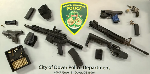
DOVER, DE - The Dover Police Department has made two arrests, both from Dover, following an investigation related to firearms.

Sussex County Detectives Arrest Selbyville Man on Drug Dealing and Gun Charges
Latest News

Sussex County Detectives Arrest Selbyville Man on Drug Dealing and Gun Charges

  • Chaz Gill
  • Jun 26, 2023

SELBYVILLE, Del.-Delaware State Police have arrested a Selbyville man on charges related to drug dealing and illegal firearm possession. 

site-logo
  • Facebook
  • Twitter
  • LinkedIn
  • YouTube
  • Instagram

Sections

  • Latest Newscasts
  • Local News
  • Weather
  • Features
  • DelmarvaLife
  • Outdoors Delmarva
  • Delmarva Home Show
  • CoastTV
  • Telemundo Delmarva
  • Delmarva Sports Network
  • Video Center

Services

  • Search
  • Pay My Bill
  • Advertise With Us
  • Contact Us
  • Careers
  • Internships

Browser Compatibility

Your browser is out of date and potentially vulnerable to security risks.
We recommend switching to one of the following browsers:

Microsoft Edge Google Chrome Firefox
FCC Public File Applications & Related Materials EEO Public File Report FCC Closed Captioning Concerns Children's Programming Transparency Requirements for Group Health Plans
© Copyright 2025 WBOC TV 1729 N. Salisbury BLVD, Salisbury, MD  | Terms of Use  | Privacy Policy
Powered by BLOX Content Management System from BLOX Digital.