  • Facebook
  • Twitter
  • LinkedIn
  • YouTube
  • Instagram
  • Sign Up
  • Log In
  • Dashboard
  • Logout
    • My Account
    • Dashboard
    • Profile
    • Saved items
    • Logout
Home
  • About WBOC
  • Our Team
  • Programming
  • Contact Us
  • Careers
  • Internships
  • Policies
  • Report It
  • Get our newsletters
  • WBOC Apps
News
  • Wicomico County
  • Worcester County
  • Somerset County
  • Dorchester County
  • Caroline County
  • Talbot County
  • Queen Annes County
  • Sussex County
  • Kent County
  • Accomack County
  • National News
  • International News
  • Latest Newscasts
  • Video Center
Weather
  • Forecast
  • Radar
  • Satellite
  • On The Waters
  • Weather Cameras
  • Closings
Delmarva Sports Network
Shows
  • DelmarvaLife
  • Outdoors Delmarva
  • Delmarva Home Show
Features
  • Bless Our Children
  • Holiday House
  • Obituaries
  • Heartbeat of Delmarva
  • Proud To Serve
  • The M Report
  • Farming Our Future
  • Farm to Table Scholarship
  • Events: Job Fair
Radio
  • WDEL
  • 100.9% Classic Country
  • 107.1 The Duck
  • 102.5 WBOC FM
  • 93.5 The Beach
  • 107.7 BIG Classic Rock
  • 103.9 & 106.3 Coast Country
  • 93.7 WSTW
  • WXCY 103.7 & 96.9
  • WCEI 96.7
  • 94.3 Dockside
  • Watch Live
  • Apps
  • Contact Us
  • My Account
  • Sign Up
  • Log In
  • Dashboard
  • Logout
    • My Account
    • Dashboard
    • Profile
    • Saved items
    • Logout
  • Facebook
  • Twitter
  • LinkedIn
  • YouTube
  • Instagram
  • 19°
    • Salisbury, MD (21801)

      Today

      Partly cloudy skies early will give way to cloudy skies late. A few flurries or snow showers possible. Low 14F. Winds N at 15 to 25 mph..

      Tonight

      Partly cloudy skies early will give way to cloudy skies late. A few flurries or snow showers possible. Low 14F. Winds N at 15 to 25 mph.

      Updated: January 31, 2026 @ 11:23 pm

    • Full Forecast
site-logo
Watch Live

Newscast Schedule

View Programming Schedule
site-logo
  • 19°
  • Home
  • News
    • Wicomico County
    • Worcester County
    • Somerset County
    • Dorchester County
    • Caroline County
    • Talbot County
    • Queen Anne's County
    • Sussex County
    • Kent County
    • Accomack County
    • National News
    • International News
    • Latest Newscasts
    • Video Center
    • Report It
  • Weather
    • Forecast
    • Radar
    • Satellite
    • On The Waters
    • Weather Cameras
    • Closings
  • Delmarva Sports Network
  • Shows
    • DelmarvaLife
    • Outdoors Delmarva
    • Delmarva Home Show
  • Features
    • Bless Our Children
    • Holiday House
    • Obituaries
    • Heartbeat of Delmarva
    • The M Report
    • Proud To Serve
    • Farming Our Future
    • Farm to Table Scholarship
    • Jefferson Awards
    • Delmarva Experts
    • Events: Job Fair
  • Radio
    • WDEL
    • 100.9% Classic Country
    • 107.1 The Duck
    • 93.5 The Beach
    • 107.7 BIG Classic Rock
    • 103.9 & 106.3 Coast Country
    • 102.5 WBOC FM
    • 93.7 WSTW
    • WXCY 103.7 & 96.9
    • WCEI 96.7
    • 94.3 WINX
  • About Us
    • About WBOC
    • Our Team
    • Channel Finder
    • Apps
    • Contact Us
    • Get our newsletters
    • Careers
    • Internships
    • Policies
    • WBOC Solar Farm
  • Report It

WINTER STORM

Download Weather App

Broadcast Schedule

On air schedule

Weather Alert

Weather Alert

...GALE WARNING REMAINS IN EFFECT UNTIL MIDNIGHT EST SUNDAY
NIGHT...
...HEAVY FREEZING SPRAY WARNING REMAINS IN EFFECT UNTIL 10 AM EST
SUNDAY...

* WHAT...For the Gale Warning, northwest winds 20 to 30 kt with
gusts up to 40 kt and waves 3 to 6 ft. For the Heavy Freezing
Spray Warning, heavy freezing spray at a rate of 2 cm per hour
or greater expected, and may rapidly accumulate on vessels.

* WHERE...Chesapeake Bay from Drum Point MD to Smith Point VA
and Tangier Sound and the inland waters surrounding
Bloodsworth Island.

* WHEN...For the Gale Warning, until midnight EST Sunday night.
For the Heavy Freezing Spray Warning, until 10 AM EST Sunday.

* IMPACTS...Operating a vessel in heavy freezing spray is
hazardous. Freezing spray may render mechanical and electronic
components inoperative. Rapid ice accretion on decks and
superstructures may result in a catastrophic loss of
stability. Strong winds will cause hazardous waves which could
capsize or damage vessels.

PRECAUTIONARY/PREPAREDNESS ACTIONS...

Mariners should prepare for dangerous accumulation of ice on
their vessel. If possible, remain in port, avoid the warning area
or conduct mitigation.

Mariners should alter plans to avoid these hazardous conditions.
Remain in port, seek safe harbor, alter course, and/or secure the
vessel for hazardous conditions.

&&

Weather Alert

...COLD WEATHER ADVISORY REMAINS IN EFFECT UNTIL 10 AM EST SUNDAY...
...WIND ADVISORY REMAINS IN EFFECT UNTIL 4 PM EST SUNDAY...

* WHAT...For the Cold Weather Advisory, very cold wind chills as low
as 3 below expected. For the Wind Advisory, north winds 20 to 30
mph with gusts up to 50 mph expected.

* WHERE...Inland Worcester, Maryland Beaches, Somerset, and Wicomico
Counties.

* WHEN...For the first Cold Weather Advisory, second Cold Weather
Advisory, and third Cold Weather Advisory, until 10 AM EST Sunday.
For the Wind Advisory, until 4 PM EST Sunday.

* IMPACTS...Gusty winds will blow around unsecured objects. Tree
limbs could be blown down and a few power outages may result. The
cold wind chills as low as 5 below zero could result in
hypothermia if precautions are not taken.

PRECAUTIONARY/PREPAREDNESS ACTIONS...

Winds this strong can make driving difficult, especially for high
profile vehicles. Use extra caution.

Use caution while traveling outside. Wear appropriate clothing, a
hat, and gloves.

&&

Closings

Click here to view closings and delays

Advanced Search Close Search
From
To
Close Search
Federal budget cuts threaten oyster production at Horn Point hatchery
Latest News

Federal budget cuts threaten oyster production at Horn Point hatchery

  • Maegan Summers
  • Updated Jan 12, 2026

Federal budget cuts could significantly reduce oyster production at the Horn Point Oyster Hatchery in Dorchester County, according to the facility’s director.

1:59
Virginia minimum wage rises to $12.77 in new year as $15 debate looms
Latest News

Virginia minimum wage rises to $12.77 in new year as $15 debate looms

  • Updated Dec 31, 2025

Virginia’s minimum wage is set to increase Jan. 1, a change state labor officials say is tied directly to inflation and one that is already re…

1:52
Small businesses brace for penny phaseout as cash change gets complicated
Latest News

Small businesses brace for penny phaseout as cash change gets complicated

  • Updated Dec 29, 2025

A souvenir penny from Berlin may look like a simple keepsake, but it now represents a bigger shift happening at cash registers nationwide.

Rehoboth Beach plans $1.1 million safety upgrade with new bollards, gates on Rehoboth Avenue
Latest News

Rehoboth Beach plans $1.1 million safety upgrade with new bollards, gates on Rehoboth Avenue

  • Jack Ford
  • Updated Oct 7, 2025

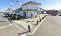
City officials in Rehoboth Beach have announced plans to install new safety barriers at the end of Rehoboth Avenue as part of a $1.1 million pedestrian protection project.

Federal EV tax credit ends Sept. 30, some last-minute buyers rush to take advantage
Latest News

Federal EV tax credit ends Sept. 30, some last-minute buyers rush to take advantage

  • Jack Ford
  • Updated Sep 29, 2025

Time is running out for electric vehicle buyers to cash in on federal tax credits worth thousands of dollars.

Sussex County Property Tax Bills Reflect First Reassessment in Decades
Latest News

Sussex County Property Tax Bills Reflect First Reassessment in Decades

  • Jack Ford
  • Updated Aug 12, 2025

Sussex County has begun issuing its annual tax bills, which include county water and sewer rates, school taxes, and for the first time in decades, newly reassessed property values.

2:10
The Feds Deliver A Heartbreaking Blow To A Project In Worcester County
Latest News

The Feds Deliver A Heartbreaking Blow To A Project In Worcester County

  • Updated Aug 7, 2025

Nearly $1 million has been stripped from the town of Berlin. The money would have been crucial in the town's efforts to bridge the gap over US…

4:03
The White Marlin Open Has Arrived, But Inclement Offshore Weather May Not Be Far Behind
Latest News

The White Marlin Open Has Arrived, But Inclement Offshore Weather May Not Be Far Behind

  • Updated Aug 4, 2025

Monday marked the first day of fishing for the 52nd Annual White Marlin Open. There is more than $7 million worth of prize money on the line t…

1:59
Water Woes Are Plaguing A Town In Worcester County
Latest News

Water Woes Are Plaguing A Town In Worcester County

  • Updated Jul 31, 2025

Newark's water treatment plant is more than 40 years old and needs several expensive upgrades. With no federal money coming in, however, neigh…

Berlin Raises $10K Through Street Sign Auction for Community Center Project
Latest News

Berlin Raises $10K Through Street Sign Auction for Community Center Project

  • Jack Ford
  • Updated Jul 15, 2025

The Town of Berlin has raised more than $10,000 through an online auction of retired street signs, with proceeds going toward the development of a new community center on Flower Street.

  •  
  • 1 of 26
  •  
site-logo
  • Facebook
  • Twitter
  • LinkedIn
  • YouTube
  • Instagram

Sections

  • Latest Newscasts
  • Local News
  • Weather
  • Features
  • DelmarvaLife
  • Outdoors Delmarva
  • Delmarva Home Show
  • CoastTV
  • Telemundo Delmarva
  • Delmarva Sports Network
  • Video Center

Services

  • Search
  • Pay My Bill
  • Advertise With Us
  • Contact Us
  • Careers
  • Internships

Browser Compatibility

Your browser is out of date and potentially vulnerable to security risks.
We recommend switching to one of the following browsers:

Microsoft Edge Google Chrome Firefox
FCC Public File Applications & Related Materials EEO Public File Report FCC Closed Captioning Concerns Children's Programming Transparency Requirements for Group Health Plans
© Copyright 2026 WBOC TV 1729 N. Salisbury BLVD, Salisbury, MD  | Terms of Use  | Privacy Policy
Powered by BLOX Content Management System from BLOX Digital.