FILE - Suspected serial killer Jeffrey L. Dahmer sits in court for a hearing where he was charged with eight additional counts of first degree intentional homicide, bringing the total to 12, Aug. 7, 1991. (AP Photo/Jack Orton/Pool, File)
FILE - Suspected serial killer Jeffrey L. Dahmer sits in court for a hearing where he was charged with eight additional counts of first degree intentional homicide, bringing the total to 12, Aug. 7, 1991. (AP Photo/Jack Orton/Pool, File)
The Caroline County Sheriff’s Office has announced the arrest of a man in Preston on numerous charges including attempted murder after police say he opened fire on them on Thursday.
The Appellate Court of Maryland has made a controversial decision regarding "Anton's Law." The court rules that police departments must releas…
On Monday night, the City Council moved forward with a proposal to end Salisbury's City Worker Union Agreement. Currently, city employees, inc…
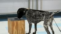
The Laurel Police Department is seeking donations to add two new K-9 officers as its current police dog prepares for retirement.

The Laurel Police Department is seeking donations to add two new K-9 officers as its current police dog prepares for retirement.
Higher pay and enticing incentives at the federal level are pulling police officers away from local law enforcement agencies across Delmarva, …

The Delaware Department of Correction is shifting its K9 program away from traditional patrol work and focusing entirely on detecting drugs, electronics, and other contraband inside state correctional facilities.
County leaders did not approve Ocean City's request for an additional $1.4 million. Ocean City stated that it would have used the money to hir…
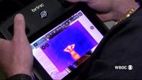
Drones are the newest tool being used by the Cambridge Police Department, providing officers with eyes in the sky for high-risk situations.