  • Facebook
  • Twitter
  • LinkedIn
  • YouTube
  • Instagram
  • Sign Up
  • Log In
  • Dashboard
  • Logout
    • My Account
    • Dashboard
    • Profile
    • Saved items
    • Logout
Home
  • About WBOC
  • Our Team
  • Programming
  • Contact Us
  • Careers
  • Internships
  • Policies
  • Report It
  • Get our newsletters
  • WBOC Apps
News
  • Wicomico County
  • Worcester County
  • Somerset County
  • Dorchester County
  • Caroline County
  • Talbot County
  • Queen Annes County
  • Sussex County
  • Kent County
  • Accomack County
  • National News
  • International News
  • Latest Newscasts
  • Video Center
Weather
  • Forecast
  • Radar
  • Satellite
  • On The Waters
  • Weather Cameras
  • Closings
Delmarva Sports Network
Shows
  • DelmarvaLife
  • Outdoors Delmarva
  • Delmarva Home Show
Features
  • Bless Our Children
  • Holiday House
  • Obituaries
  • Heartbeat of Delmarva
  • Proud To Serve
  • The M Report
  • Farming Our Future
  • Farm to Table Scholarship
  • Events: Job Fair
Radio
  • WDEL
  • 100.9% Classic Country
  • 107.1 The Duck
  • 102.5 WBOC FM
  • 93.5 The Beach
  • 107.7 BIG Classic Rock
  • 103.9 & 106.3 Coast Country
  • 93.7 WSTW
  • WXCY 103.7 & 96.9
  • WCEI 96.7
  • 94.3 Dockside
  • Watch Live
  • Apps
  • Contact Us
  • My Account
  • Sign Up
  • Log In
  • Dashboard
  • Logout
    • My Account
    • Dashboard
    • Profile
    • Saved items
    • Logout
  • Facebook
  • Twitter
  • LinkedIn
  • YouTube
  • Instagram
  • 16° Clear
    • Salisbury, MD (21801)

      Today

      Sunshine and some clouds. High 24F. Winds NW at 10 to 15 mph..

      Tonight

      Partly cloudy. Very cold. Low 9F. Winds N at 5 to 10 mph.

      Updated: January 30, 2026 @ 1:35 am

    • Full Forecast
site-logo
Watch Live

Newscast Schedule

View Programming Schedule
site-logo
  • 16°
  • Home
  • News
    • Wicomico County
    • Worcester County
    • Somerset County
    • Dorchester County
    • Caroline County
    • Talbot County
    • Queen Anne's County
    • Sussex County
    • Kent County
    • Accomack County
    • National News
    • International News
    • Latest Newscasts
    • Video Center
    • Report It
  • Weather
    • Forecast
    • Radar
    • Satellite
    • On The Waters
    • Weather Cameras
    • Closings
  • Delmarva Sports Network
  • Shows
    • DelmarvaLife
    • Outdoors Delmarva
    • Delmarva Home Show
  • Features
    • Bless Our Children
    • Holiday House
    • Obituaries
    • Heartbeat of Delmarva
    • The M Report
    • Proud To Serve
    • Farming Our Future
    • Farm to Table Scholarship
    • Jefferson Awards
    • Delmarva Experts
    • Events: Job Fair
  • Radio
    • WDEL
    • 100.9% Classic Country
    • 107.1 The Duck
    • 93.5 The Beach
    • 107.7 BIG Classic Rock
    • 103.9 & 106.3 Coast Country
    • 102.5 WBOC FM
    • 93.7 WSTW
    • WXCY 103.7 & 96.9
    • WCEI 96.7
    • 94.3 WINX
  • About Us
    • About WBOC
    • Our Team
    • Channel Finder
    • Apps
    • Contact Us
    • Get our newsletters
    • Careers
    • Internships
    • Policies
    • WBOC Solar Farm
  • Report It

WINTER STORM

Download Weather App

Broadcast Schedule

On air schedule

Weather Alert

Weather Alert

...SMALL CRAFT ADVISORY REMAINS IN EFFECT UNTIL 6 AM EST EARLY
THIS MORNING...
...SMALL CRAFT ADVISORY IN EFFECT FROM MIDNIGHT TONIGHT TO 6 PM
EST SATURDAY...
...GALE WATCH REMAINS IN EFFECT FROM SATURDAY EVENING THROUGH
SUNDAY EVENING...
...HEAVY FREEZING SPRAY WATCH IN EFFECT FROM LATE SATURDAY NIGHT
THROUGH SUNDAY MORNING...

* WHAT...For the first Small Craft Advisory, north winds 10 to
15 kt with gusts up to 20 kt. For the second Small Craft
Advisory, north winds 15 to 25 kt expected. For the Gale
Watch, north winds 25 to 35 kt with gusts up to 45 kt and
waves 3 to 6 ft possible. For the Heavy Freezing Spray Watch,
heavy freezing spray at a rate of 2 cm per hour or greater
possible, and may rapidly accumulate on vessels.

* WHERE...Chesapeake Bay from Drum Point MD to Smith Point VA
and Tangier Sound and the inland waters surrounding
Bloodsworth Island.

* WHEN...For the first Small Craft Advisory, until 6 AM EST
early this morning. For the second Small Craft Advisory, from
midnight tonight to 6 PM EST Saturday. For the Gale Watch,
from Saturday evening through Sunday evening. For the Heavy
Freezing Spray Watch, from late Saturday night through Sunday
morning.

* IMPACTS...Operating a vessel in heavy freezing spray is
hazardous. Freezing spray may render mechanical and electronic
components inoperative. Ice accretion on decks and
superstructures may result in a catastrophic loss of
stability. Strong winds can cause hazardous waves which could
capsize or damage vessels.

PRECAUTIONARY/PREPAREDNESS ACTIONS...

Mariners should consider altering plans to avoid or mitigate
hazardous accumulation of ice on their vessel.

Mariners should consider altering plans to avoid possible
hazardous conditions.  Remain in port, seek safe harbor, alter
course, and/or secure the vessel for severe wind and waves.

&&

Weather Alert

...COLD WEATHER ADVISORY REMAINS IN EFFECT UNTIL 10 AM EST FRIDAY...
...EXTREME COLD WATCH REMAINS IN EFFECT FROM LATE SATURDAY NIGHT
THROUGH SUNDAY MORNING...

* WHAT...For the Cold Weather Advisory, very cold wind chills as low
as 0 expected. For the Extreme Cold Watch, dangerously cold wind
chills as low as 5 to 10 below possible.

* WHERE...Dorchester, Inland Worcester, Maryland Beaches, Somerset,
and Wicomico Counties.

* WHEN...For the Cold Weather Advisory, until 10 AM EST Friday. For
the Extreme Cold Watch, from late Saturday night through Sunday
morning.

* IMPACTS...Frostbite and hypothermia will occur if unprotected skin
is exposed to these temperatures. An extended period of freezing
temperatures could cause ruptured water pipes.

PRECAUTIONARY/PREPAREDNESS ACTIONS...

Dress in layers including a hat, face mask, and gloves if you must
go outside.

Make frequent checks on older family, friends, and neighbors. Ensure
portable heaters are used correctly. Do not use generators or grills
inside.

Monitor the latest forecasts and warnings for updates.

&&

Closings

Click here to view closings and delays

Advanced Search Close Search
From
To
Close Search
+4
Ocean City Fire Department conducts ice rescue training and warns public of ice dangers
Latest News

Ocean City Fire Department conducts ice rescue training and warns public of ice dangers

  • Nicole Harmon
  • 9 hrs ago

The Ocean City Fire Department conducted hands-on ice rescue training on local bay waters today as freezing temperatures continue to impact Delmarva.

Swim Advisories Issued Near Lewes Beaches Due to Elevated Bacteria Levels
Latest News

Swim Advisories Issued Near Lewes Beaches Due to Elevated Bacteria Levels

  • Jack Ford
  • Updated Jul 23, 2025

Swim advisories were issued Tuesday at two beaches in Sussex County after water tests showed elevated levels of Enterococcus bacteria, a fecal indicator bacteria, according to the Delaware Department of Natural Resources and Environmental Control (DNREC).

Drought Warning Issued for Most of Maryland
Latest News

Drought Warning Issued for Most of Maryland

  • Sean Curtis
  • Updated Apr 3, 2025

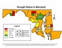
The Maryland Department of Environment (MDE) has issued a drought warning for the majority of the state due to lasting dry conditions and the past year seeing below-average rainfall. 

2:39
City Leaders in Rehoboth Beach Urge Neighbors to Conserve Water Amidst Delaware Drought Watch
Latest News

City Leaders in Rehoboth Beach Urge Neighbors to Conserve Water Amidst Delaware Drought Watch

  • Updated Oct 30, 2024

As drought conditions continue on Delmarva, Delaware state officials urge people to conserve water by declaring a statewide drought watch. Cit…

2:56
WBOC Morning Weather: October 28, 2024
WBOC Weather

WBOC Morning Weather: October 28, 2024

  • Updated Oct 28, 2024

Local forecast for Monday, October 28, 2024.

2:02
Residents Continue to Question Absence of Tornado Warning in Sussex County
Latest News

Residents Continue to Question Absence of Tornado Warning in Sussex County

  • Updated Apr 19, 2023

Nearly three weeks after a deadly tornado struck Delaware many victims are still questioning why they did not receive an emergency alert befor…

Smoke detector in apartment
Delmarvalife

Smoke detector in apartment

  • By DelmarvaLife Staff
  • May 14, 2021

Smoke detector mounted on roof in apartment

6:16
WRDE Chief Meteorologist, Paul Williams, Discusses Possibility of Winter Storms on Delmarva
Archive

WRDE Chief Meteorologist, Paul Williams, Discusses Possibility of Winter Storms on Delmarva

  • Updated Oct 25, 2021

WRDE Chief Meterologist Paul Williams talks about the possibility of a wintery pattern making its way to Delmarva.

site-logo
  • Facebook
  • Twitter
  • LinkedIn
  • YouTube
  • Instagram

Sections

  • Latest Newscasts
  • Local News
  • Weather
  • Features
  • DelmarvaLife
  • Outdoors Delmarva
  • Delmarva Home Show
  • CoastTV
  • Telemundo Delmarva
  • Delmarva Sports Network
  • Video Center

Services

  • Search
  • Pay My Bill
  • Advertise With Us
  • Contact Us
  • Careers
  • Internships

Browser Compatibility

Your browser is out of date and potentially vulnerable to security risks.
We recommend switching to one of the following browsers:

Microsoft Edge Google Chrome Firefox
FCC Public File Applications & Related Materials EEO Public File Report FCC Closed Captioning Concerns Children's Programming Transparency Requirements for Group Health Plans
© Copyright 2026 WBOC TV 1729 N. Salisbury BLVD, Salisbury, MD  | Terms of Use  | Privacy Policy
Powered by BLOX Content Management System from BLOX Digital.