


SALISBURY, Md. - Hurricane season in the Atlantic is well under way, and in contrast to some recent years, it hasn't been too terribly active. So far, there have been five storms, including only one hurricane, "Don," which just meandered around out in the central Atlantic.
El Niño and Saharan dust have been cited for the slow start to the season, but according to forecasters with the National Oceanic and Atmospheric Administration (NOAA), the latest analysis is showing other factors that could lead to an increase in tropical development.
"We came to the determination that the El Niño impacts are developing slightly slower than we thought, and the sea surface temperatures and patterns in the Atlantic are more conducive than was initially forecast in May," said Matthew Rosencrans, lead hurricane forecaster with NOAA.
The latest forecast is for a 60 percent chance of an above normal season, and that should have East Coast neighbors keeping their eyes on the tropics.
"So when we have active years, or above normal years, the odds of a hurricane hitting the East Coast of the U.S. double," said Rosencrans.
Delmarva is no stranger to tropical systems, and its unique geography means neighbors need to be prepared for a hurricane's number one killer.
"Typically on the Delmarva, the largest threat is the coastal flooding and surge, whether it's on the Chesapeake side, or the ocean side," said Rosencrans. "When you couple that with heavy rain, low sloping topography, you can really build up a lot of water and a lot of flooding very quickly."
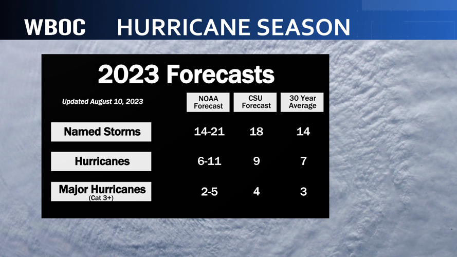
In NOAA's latest forecast, they are predicting anywhere from 14 to 21 named storms, with anywhere from 6 to 11 hurricanes, 2 to 5 of which could be major hurricanes.
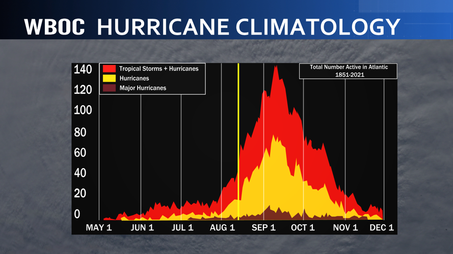
It is normal for a hurricane season to be slow through mid August. According to the National Hurricane Center, 70 percent of tropical activity in the Atlantic Basin occurs after August 20.
