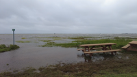
This product covers CENTRAL AND EASTERN VIRGINIA...NORTHEAST NORTH CAROLINA...AND THE LOWER MARYLAND EASTERN SHORE
**ERIN MOVING AWAY FROM THE NORTH CAROLINA COAST**
NEW INFORMATION
---------------
* CHANGES TO WATCHES AND WARNINGS:
- None
* CURRENT WATCHES AND WARNINGS:
- A Tropical Storm Warning is in effect for Accomack, Eastern
Currituck, Northampton, Virginia Beach, and Western Currituck
* STORM INFORMATION:
- About 350 miles east-southeast of Ocean City MD or about 400
miles east of Norfolk VA
- 36.4N 69.1W
- Storm Intensity 100 mph
- Movement Northeast or 50 degrees at 20 mph
SITUATION OVERVIEW
------------------
Hurricane Erin, currently about 370 miles ENE of Cape Hatteras, NC,
continues to move northeast away from the coast. Erin will continue to
move northeastward with the center of the storm tracking well offshore
of the Mid-Atlantic coast. However, Erin is expected to grow in size,
and tropical storm force gusts are expected to continue through this
evening across Virginia Beach, Currituck County, as well as the
Maryland, Virginia and northeast North Carolina Coastal Waters. Winds
of 30 to 40 mph with gusts of 45 to 50 mph are possible close to the
coast south of Chincoteague.
Regardless of the exact track, Erin will continue to bring high surf,
significant dune and beach erosion and moderate to locally major tidal
flooding to the area. Seas of 12 to 18 feet over the coastal waters
remain possible this evening into tonight which will allow for
significant beach and dune erosion for the coast especially around the
times of high tide. In addition, moderate to locally major coastal
flooding is expected during the high tide cycle this evening and
tonight with inundation of 1 to 3 feet above normally high ground. A
Coastal Flood Warning remains in effect for the Atlantic coast from
Corolla, NC to Ocean City, MD, areas adjacent to the Chesapeake Bay
from Windmill Point south, tidal portions of the James, York, and
Rappahannock Rivers as well as adjacent estuaries. A Coastal Flood
Warning is also now in effect for areas adjacent to the Chesapeake Bay
north of Windmill Point through the bay side of the lower Maryland
Eastern Shore, and the southern shore of the Potomac River, as well as
adjacent estuaries.
POTENTIAL IMPACTS
-----------------
* SURGE:
Potential impacts from the main surge event are now unfolding across
all of the shoreline from Maryland through Virginia to NE North
Carolina, including the lower and middle Chesapeake Bay. If realized,
these impacts include:
- Widespread storm surge flooding of vulnerable areas will result
in an elevated threat of property damage to homes and
businesses near the waterfront and shoreline.
- Sections of low-lying vulnerable roads, parking lots and
property will likely become flooded. Driving conditions could
become dangerous in places where flooding covers the road.
- Moderate to severe beach erosion is likely, including heavy
surf possibly breaching dunes, especially in vulnerable
locations. Strong and dangerous rip currents are likely.
- Minor to moderate damage to marinas, docks, boardwalks, and
piers is likely. A few small craft broken away from moorings.
Elsewhere across CENTRAL AND EASTERN VIRGINIA...NORTHEAST NORTH
CAROLINA...AND THE LOWER MARYLAND EASTERN SHORE, little to no impact
is anticipated.
* OTHER COASTAL HAZARDS:
Along the Atlantic coast from Fenwick Island Delaware to Duck North
Carolina, expect waves to build to 12 to 18 ft today. These large
waves combined with increased water levels will likely allow for
significant beach and dune erosion. There is a high risk of rip
currents along the shoreline through Friday, and a high risk of rip
currents will likely continue into the weekend.
* WIND:
Potential impacts from the main wind event are now unfolding across the
area close to the shoreline from Chincoteague VA to Duck NC. A north
wind continues to gust to 35 to 45 mph along the Atlantic coast of
Virginia Beach and the Currituck Outer Banks. Remain well sheltered
from hazardous wind having limited impacts. If realized, these impacts
include:
- Damage to porches, awnings, carports, sheds, and unanchored
mobile homes. Unsecured lightweight objects blown about.
- Many large tree limbs broken off. A few trees snapped or
uprooted, especially if soils are saturated. Some roadway signs
will sustain damage.
- A few roads will be impassable from debris. Hazardous driving
conditions on bridges and other elevated roadways.
- Scattered power and communications outages.
Elsewhere across CENTRAL AND EASTERN VIRGINIA...NORTHEAST NORTH
CAROLINA...AND THE LOWER MARYLAND EASTERN SHORE, little to no impact
is anticipated.
PRECAUTIONARY/PREPAREDNESS ACTIONS
----------------------------------
* EVACUATIONS:
A mandatory evacuation for the off-road area of Corolla has been
effective as of 9 AM EDT Wednesday August 20th.
* OTHER PREPAREDNESS INFORMATION:
If you are prone to coastal flooding or ocean overwash be prepared for
the possibility of a quick rise in water levels.
Closely monitor weather.gov, NOAA Weather Radio and local news outlets
for official storm information. Listen for possible changes to the
forecast.
* ADDITIONAL SOURCES OF INFORMATION:
- For information on appropriate preparations see
www.readyvirginia.gov, readync.org or mema.maryland.gov
- For the latest weather and storm information go to
weather.gov/wakefield
NEXT UPDATE
-----------
The next local statement will be issued by the National Weather
Service in Wakefield VA around 8 PM EDT, or sooner if conditions
warrant.