


Wicomico County’s main library is one step closer to a new home, with state funding helping move forward renovations at the former Ward Museum…
From
To


Officials with the City of Salisbury have announced the Naylor Mill Water Main Extension Project will begin this month. An outside contractor is expected to begin work on June 29, with the project expected to be completed in June 2027.

Pocomoke City Mayor Todd Nock has announced that phase 1 of the Mayor's Safe Path Initiative will officially begin on June 22 and continue through July 17. The mayor describes this as a major investment in city infrastructure and a commitment to improving the safety, appearance, and quality of life in Pocomoke.


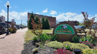
A long-vacant downtown Pocomoke City building is moving closer to new life after city officials approved final site plans for a mixed-use rede…


A proposed solar project near Centreville is drawing opposition from local leaders and conservation advocates who say the development could im…


Construction is taking place at Easton Airport as officials push forward with a multi-year project aimed at modernizing the airfield.


Pocomoke City is moving forward with the first phase of a street and sidewalk improvement project city leaders say has been years in the making.


A couple’s home renovation project in Lewes has been halted by a partial stop-work order, leaving the project partially complete and the owner…


A proposal to demolish and rebuild Berlin Intermediate School is moving to the state level after Worcester County leaders advanced a feasibili…