  • Facebook
  • Twitter
  • LinkedIn
  • YouTube
  • Instagram
  • Sign Up
  • Log In
  • Dashboard
  • Logout
    • My Account
    • Dashboard
    • Profile
    • Saved items
    • Logout
Home
  • About WBOC
  • Our Team
  • Programming
  • Contact Us
  • Careers
  • Internships
  • Policies
  • Report It
  • Get our newsletters
  • WBOC Apps
News
  • Wicomico County
  • Worcester County
  • Somerset County
  • Dorchester County
  • Caroline County
  • Talbot County
  • Queen Annes County
  • Sussex County
  • Kent County
  • Accomack County
  • National News
  • International News
  • Latest Newscasts
  • Video Center
Weather
  • Forecast
  • Radar
  • Satellite
  • On The Waters
  • Weather Cameras
  • Closings
Delmarva Sports Network
Shows
  • DelmarvaLife
  • Outdoors Delmarva
  • Delmarva Home Show
Features
  • Bless Our Children
  • Holiday House
  • Obituaries
  • Heartbeat of Delmarva
  • Proud To Serve
  • The M Report
  • Farming Our Future
  • Farm to Table Scholarship
  • Events: Job Fair
Radio
  • WDEL
  • 100.9% Classic Country
  • 107.1 The Duck
  • 102.5 WBOC FM
  • 93.5 The Beach
  • 107.7 BIG Classic Rock
  • 103.9 & 106.3 Coast Country
  • 93.7 WSTW
  • WXCY 103.7 & 96.9
  • WCEI 96.7
  • 94.3 Dockside
  • Watch Live
  • Apps
  • Contact Us
  • My Account
  • Sign Up
  • Log In
  • Dashboard
  • Logout
    • My Account
    • Dashboard
    • Profile
    • Saved items
    • Logout
  • Facebook
  • Twitter
  • LinkedIn
  • YouTube
  • Instagram
  • 19°
    • Salisbury, MD (21801)

      Today

      Partly cloudy skies early will give way to cloudy skies late. A few flurries or snow showers possible. Low 14F. Winds N at 15 to 25 mph..

      Tonight

      Partly cloudy skies early will give way to cloudy skies late. A few flurries or snow showers possible. Low 14F. Winds N at 15 to 25 mph.

      Updated: January 31, 2026 @ 11:23 pm

    • Full Forecast
site-logo
Watch Live

Newscast Schedule

View Programming Schedule
site-logo
  • 19°
  • Home
  • News
    • Wicomico County
    • Worcester County
    • Somerset County
    • Dorchester County
    • Caroline County
    • Talbot County
    • Queen Anne's County
    • Sussex County
    • Kent County
    • Accomack County
    • National News
    • International News
    • Latest Newscasts
    • Video Center
    • Report It
  • Weather
    • Forecast
    • Radar
    • Satellite
    • On The Waters
    • Weather Cameras
    • Closings
  • Delmarva Sports Network
  • Shows
    • DelmarvaLife
    • Outdoors Delmarva
    • Delmarva Home Show
  • Features
    • Bless Our Children
    • Holiday House
    • Obituaries
    • Heartbeat of Delmarva
    • The M Report
    • Proud To Serve
    • Farming Our Future
    • Farm to Table Scholarship
    • Jefferson Awards
    • Delmarva Experts
    • Events: Job Fair
  • Radio
    • WDEL
    • 100.9% Classic Country
    • 107.1 The Duck
    • 93.5 The Beach
    • 107.7 BIG Classic Rock
    • 103.9 & 106.3 Coast Country
    • 102.5 WBOC FM
    • 93.7 WSTW
    • WXCY 103.7 & 96.9
    • WCEI 96.7
    • 94.3 WINX
  • About Us
    • About WBOC
    • Our Team
    • Channel Finder
    • Apps
    • Contact Us
    • Get our newsletters
    • Careers
    • Internships
    • Policies
    • WBOC Solar Farm
  • Report It

WINTER STORM

Download Weather App

Broadcast Schedule

On air schedule

Weather Alert

Weather Alert

...GALE WARNING REMAINS IN EFFECT UNTIL MIDNIGHT EST SUNDAY
NIGHT...
...HEAVY FREEZING SPRAY WARNING REMAINS IN EFFECT UNTIL 10 AM EST
SUNDAY...

* WHAT...For the Gale Warning, northwest winds 20 to 30 kt with
gusts up to 40 kt and waves 3 to 6 ft. For the Heavy Freezing
Spray Warning, heavy freezing spray at a rate of 2 cm per hour
or greater expected, and may rapidly accumulate on vessels.

* WHERE...Chesapeake Bay from Drum Point MD to Smith Point VA
and Tangier Sound and the inland waters surrounding
Bloodsworth Island.

* WHEN...For the Gale Warning, until midnight EST Sunday night.
For the Heavy Freezing Spray Warning, until 10 AM EST Sunday.

* IMPACTS...Operating a vessel in heavy freezing spray is
hazardous. Freezing spray may render mechanical and electronic
components inoperative. Rapid ice accretion on decks and
superstructures may result in a catastrophic loss of
stability. Strong winds will cause hazardous waves which could
capsize or damage vessels.

PRECAUTIONARY/PREPAREDNESS ACTIONS...

Mariners should prepare for dangerous accumulation of ice on
their vessel. If possible, remain in port, avoid the warning area
or conduct mitigation.

Mariners should alter plans to avoid these hazardous conditions.
Remain in port, seek safe harbor, alter course, and/or secure the
vessel for hazardous conditions.

&&

Weather Alert

...COLD WEATHER ADVISORY REMAINS IN EFFECT UNTIL 10 AM EST SUNDAY...
...WIND ADVISORY REMAINS IN EFFECT UNTIL 4 PM EST SUNDAY...

* WHAT...For the Cold Weather Advisory, very cold wind chills as low
as 3 below expected. For the Wind Advisory, north winds 20 to 30
mph with gusts up to 50 mph expected.

* WHERE...Inland Worcester, Maryland Beaches, Somerset, and Wicomico
Counties.

* WHEN...For the first Cold Weather Advisory, second Cold Weather
Advisory, and third Cold Weather Advisory, until 10 AM EST Sunday.
For the Wind Advisory, until 4 PM EST Sunday.

* IMPACTS...Gusty winds will blow around unsecured objects. Tree
limbs could be blown down and a few power outages may result. The
cold wind chills as low as 5 below zero could result in
hypothermia if precautions are not taken.

PRECAUTIONARY/PREPAREDNESS ACTIONS...

Winds this strong can make driving difficult, especially for high
profile vehicles. Use extra caution.

Use caution while traveling outside. Wear appropriate clothing, a
hat, and gloves.

&&

Closings

Click here to view closings and delays

Advanced Search Close Search
From
To
Close Search
Cambridge: Route 50 Ocean Gateway to be Resurfaced
Latest News

Cambridge: Route 50 Ocean Gateway to be Resurfaced

  • Colby Moore
  • Updated Sep 25, 2024

State highway officials announced that both directions of Ocean Gateway will be resurfaced.

Ocean Highway in Somerset County to be Resurfaced
Latest News

Ocean Highway in Somerset County to be Resurfaced

  • Colby Moore
  • Updated Apr 8, 2024

State Highway Administration officials say road work will begin Wednesday.

Pickleball Bounce Blues: Lewes Players Frustrated by Court Conundrum
Latest News

Pickleball Bounce Blues: Lewes Players Frustrated by Court Conundrum

  • Kristina DeRobertis
  • Updated Aug 21, 2023

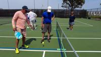
Pickleball, typically played in a 2v2 format, has taken an unexpected turn in Lewes, as players find themselves in a battle against the court itself.

MD State Highway Administration To Begin Final Resurfacing of US 50 in Dorchester County
Latest News

MD State Highway Administration To Begin Final Resurfacing of US 50 in Dorchester County

  • Victoria Todorova
  • Updated Apr 20, 2023

The Maryland Department of Transportation State Highway Administration will begin the final repaving and striping of US 50 (Ocean Gateway) near Vienna in Dorchester County on Monday, Apr. 24. 

site-logo
  • Facebook
  • Twitter
  • LinkedIn
  • YouTube
  • Instagram

Sections

  • Latest Newscasts
  • Local News
  • Weather
  • Features
  • DelmarvaLife
  • Outdoors Delmarva
  • Delmarva Home Show
  • CoastTV
  • Telemundo Delmarva
  • Delmarva Sports Network
  • Video Center

Services

  • Search
  • Pay My Bill
  • Advertise With Us
  • Contact Us
  • Careers
  • Internships

Browser Compatibility

Your browser is out of date and potentially vulnerable to security risks.
We recommend switching to one of the following browsers:

Microsoft Edge Google Chrome Firefox
FCC Public File Applications & Related Materials EEO Public File Report FCC Closed Captioning Concerns Children's Programming Transparency Requirements for Group Health Plans
© Copyright 2026 WBOC TV 1729 N. Salisbury BLVD, Salisbury, MD  | Terms of Use  | Privacy Policy
Powered by BLOX Content Management System from BLOX Digital.