


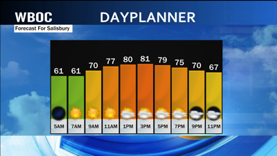
Forecast Updated on Wednesday, August 23, 2023, at 4:00am by WBOC Meteorologist Mike Lichniak
Today: Mostly sunny. Highs: 80-85. Winds: NE 5-10 mph.
Tonight: Turning partly cloudy with a stray shower possible. Lows: 62-68. Winds: N 5-15 mph.
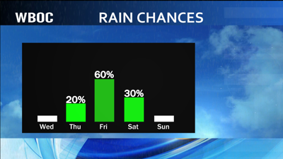
Thursday: Partly cloudy with a chance of a few showers / storms late in the day. Highs: 82-88. Winds: S 5-20+ mph.
Thursday Night: Partly to mostly cloudy with a chance of scattered showers / storms by morning. Lows: 70-75. Winds: SW 5-15 mph.
Friday: Partly to mostly cloudy with on and off showers / storms. Highs: 82-92. Winds: SW-NW 5-20+ mph.
Saturday: Partly to mostly sunny with a few showers / storms possible. Highs: 84-90. Winds: W-NW 5-20+ mph.
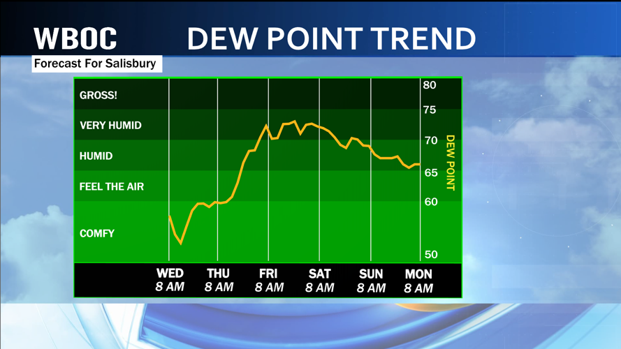
The high pressure that has been overhead remains for one more day and will keep us nice and dry on this Wednesday. Expect plenty of sunshine with high temperatures in the 70s and 80s today as the humidity levels remain relatively low for much of the day.

As the wind begins to turn more out of the south and southwest overnight tonight, this is when the humidity will start to go up across Delmarva ahead of our unsettled weather pattern that will set up across the region.

A boundary to our north will start to dive toward the Peninsula on Thursday and will provide us with the chance for a few showers and storms in the evening hours. A better chance for storms looks to enter the forecast on Friday as a second cold front comes diving across Delmarva, but starts to slow down and stall out over the top of the region by Friday evening. At the moment, we will have to keep some shower and storm chances on Saturday before the front clears us on Saturday evening and a dry Sunday is ahead of us.
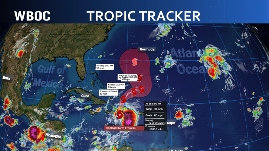
This high pressure will become a very important piece of the puzzle heading into next week as the tropics have exploded with activity in the last 48 hours.

We will be watching one of the storms in particular as Franklin has been projected by the models to take a path where we may have to deal with the swell and waves off the open Atlantic as the storm is going to pass between us and Bermuda by Wednesday of next week. Also will be keeping tabs in the Gulf of Mexico for another storm to form there early next week and could cause some issues with the forecast heading into late week with rain chances.