

***Coastal Flood Warning until September 27, 05:00 AM EDT***
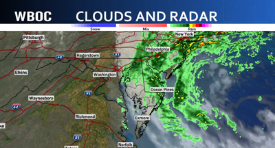
Good morning! Our big weather story this weekend is a nor'easter developing along the Mid-Atlantic coast, and it's going to make for a wet, windy, and unsettled weekend across Delmarva. Today, rain becomes likely, especially after 8 AM, as the nor'easter strengthens just offshore. We'll stay mostly cloudy with highs in the mid 60s. North winds will be strong, 20 to 25 mph, with gusts upwards of 45 mph. Along the coast and tidal waterways, the biggest concern will be coastal flooding, rough surf, and strong winds. The National Weather Service has coastal flood warnings in effect in portions of Delmarva, with the nor'easter expected to produce significant coastal impacts throughout the weekend. Tonight, rain bands continue, with lows in the upper 50s. Winds turn northwest at 15 to 20 miles per hour, with gusts around 30. Sunday, we're still dealing with the nor'easter. Rain remains likely, particularly through the first half of the day, with cloudy skies and a high near 64 degrees. Northwest winds will remain gusty, with some gusts reaching 30 to 35 mph.
For the coast, Sunday flooding concerns and high surf remain an issue, so if you live near the bays, tidal rivers, or the Atlantic beaches, keep an eye on those water levels and any local advisories. By Sunday night, the storm begins to pull away, and rain chances drop off. Monday stays mostly cloudy with a high around 70. Then, we finally get a major change in the pattern. Tuesday turns mostly sunny with a high near 75. Wednesday will be sunny and warmer, near 79, followed by mostly sunny skies Thursday and Friday with highs around 80 degrees.
