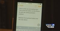
...GALE WARNING REMAINS IN EFFECT FROM 6 AM SUNDAY TO 6 AM EST
MONDAY...
* WHAT...Northwest winds 25 to 35 kt with gusts up to 40 kt and
waves 2 to 5 ft expected.
* WHERE...Chesapeake Bay from Sandy Point MD to Smith Point VA,
Tidal Potomac from Cobb Island MD to Smith Point VA, Eastern
Bay, Choptank River to Cambridge MD and the Little Choptank
River, Patuxent River to Broomes Island MD, and Tangier Sound
and the inland waters surrounding Bloodsworth Island.
* WHEN...From 6 AM Sunday to 6 AM EST Monday.
* IMPACTS...Strong winds will cause hazardous waves which could
capsize or damage vessels. Light freezing spray is also
possible over the open channel Sunday afternoon through Sunday
night.
PRECAUTIONARY/PREPAREDNESS ACTIONS...
Mariners should alter plans to avoid these hazardous conditions.
Remain in port, seek safe harbor, alter course, and/or secure the
vessel for hazardous conditions.
&&
Weather Alert
...COLD WEATHER ADVISORY IN EFFECT FROM 7 PM SUNDAY TO 9 AM EST
MONDAY...
* WHAT...Very cold wind chills as low as 4 above expected.
* WHERE...Portions of southeast Maryland and central, east central,
eastern, north central, south central, and southeast Virginia.
* WHEN...From 7 PM Sunday to 9 AM EST Monday.
* IMPACTS...Very cold temperatures and wind chills could lead to
hypothermia with prolonged exposure.
PRECAUTIONARY/PREPAREDNESS ACTIONS...
Use caution while traveling outside. Wear appropriate clothing, a
hat, and gloves.
&&
Weather Alert
...WINTER WEATHER ADVISORY REMAINS IN EFFECT FROM 1 AM TO 1 PM EST
SUNDAY...
* WHAT...Snow expected. Total snow accumulations up to two inches.
* WHERE...Dorchester and Wicomico Counties.
* WHEN...From 1 AM to 1 PM EST Sunday.
* IMPACTS...Plan on slippery road conditions.
PRECAUTIONARY/PREPAREDNESS ACTIONS...
Slow down and use caution while traveling. Call 511 for road
information.
&&