

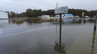

CHURCH CREEK, Md. - High water covered sections of Route 336 on Thursday, forcing drivers to turn around on the road that connects the mainland near Church Creek to Hooper’s Island. Floodwater pushed across low causeways and over the centerline at the 335/336 intersection after the most recent coastal storm.
Neighbors along the corridor said the water rose quickly through the afternoon. “It’s not as bad unless we get, like, a bad nor’easter or a hurricane come through,” said Joseph Bloodsworth, who lives near the intersection.
Bloodsworth said Thursday’s water level climbed well above what he typically sees. “Today it has been about 2 or 3ft above what it normally is, and they’re still calling for possibly five plus. Our field and pasture’s underwater. The barn kennel is all underwater,” he said.
Officials urged drivers to avoid flooded stretches and to find alternate routes if they need to reach Hooper’s Island. The National Weather Service’s safety guidance is to turn around rather than drive through standing water, since depths and road conditions can be hard to judge.
Even with the storm moving away from the region, forecasters said tides could run higher this evening, which may push water back over low spots again. Bloodsworth said he is preparing for another round. “The next tide they’re calling for tonight could actually be higher than this one. So we’re just trying to make sure everything’s ready for it,” he said.
Families nearby spent the day lifting belongings and checking vehicles as water lapped at driveways and barn doors. Bloodsworth’s young family member, Rose, said the flooding reached into farm areas. “It was over my boot,” she said.
Transportation officials advise checking local alerts and road closure updates before heading toward the island. If water is across the roadway, do not attempt to cross. Allow extra time for detours and give space to work crews that may be staging barricades or assessing damage after the tide cycle.