


Forecast Updated on Friday, December 31, 2021 at 4:15am by WBOC Meteorologist Mike Lichniak
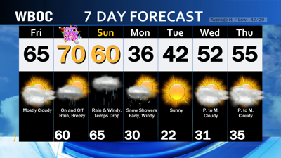
New Year’s Eve: Some fog across Delmarva early in the day. The fog deck may not break at our beach towns today. Otherwise, mostly cloudy with a couple of stray showers possible, most of us will be dry. Highs: 60-67. Winds: SW-S 5-15 mph.
Tonight: Mostly cloudy with some scattered showers possible. Lows: 57-62. Winds: SW 10-15 mph.
Saturday: Mostly cloudy with on and off showers early and mostly cloudy by the afternoon hours. Breezy late. Highs: 65-71. Winds: S-SW 10-20+ mph.
Saturday Night: Mostly cloudy with scattered showers and rain at times. Windy. Lows: 64-68. Winds: S-E 15-30+ mph.
Sunday: Periods of rain, heavy at times. Windy. Highs: 60-66. Winds: S-NE 15-30+ mph.
Monday: Starting with some light snow as the storm moves off the coast. There should not be much accumulation of snow. Otherwise, it turns mostly sunny during the afternoon. Windy and chilly! Highs: 33-38. Winds: NW 15-30+ mph. Wind chill values: 20s.
So, we are stuck in this unsettled weather pattern for the rest of 2021 and as we start 2022. The atmospheric river continues to run right over the top of Delmarva. Today will be a transition day with a mainly dry day with highs into the 60s this afternoon. As we look ahead toward midnight, our chances for some scattered showers begin to go up with temperatures in the 60s. Overnight, our rain chances start to ramp up into the early morning hours of 2022. The pattern cracking low pressure arrives over the weekend with periods of rain starting Saturday night and continuing for much of the day on Sunday. We need all the rain we could get and from the looks of the model, we could pick up on another 1-2” of rain in places through Sunday night.
Now, there are indications from the models that we will be dealing with some light snow on the backside of this storm system. This will be completely dependent on how fast that cold air could wrap back around the low as it departs on Monday morning. There is one model that is much more aggressive than the other model with this idea, but both hint toward the idea. At this point, expect to see some snow showers/flurries as we wake up on Monday morning and then things improve throughout the day.
One thing is crystal clear: a blast of big-time Canadian air arrives for next week with temperatures below average to start the first full week of 2022.