
Forecast updated on Friday, 16 August 2024, at 3:28 PM by WBOC Meteorologist Dan Satterfield (AMS Fellow-CBM).
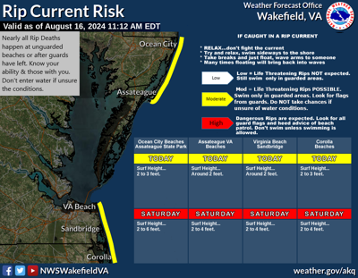
SYNOPSIS:It will turn even more humid Saturday with showers likely later Saturday and Sunday as a low pressure trough approaches the region. Swells from Hurricane Ernesto in the Atlantic will bring a HIGH risk of rip currents to all of our beaches Saturday and Sunday. Wildfire smoke from Canada made the skies hazy today but it is not as bad as yesterday. More smoke is likely in the next 7 days. Cooler weather with lower humidity will return early next week, along with some wildfire smoke.
DELMARVA FORECAST
Tonight: Increasing clouds and ore humid. Low 67-69°. Wind: S 3-7 mph.
Saturday: Partly sunny, breezy, and more humid. Late day and evening showers will become likely. High 85-86°. Wind: S 10-18 mph. Beaches reach 78° with a SE wind at 14-20 mph PM. Rip Current Risk will be HIGH on all beaches.
Saturday Night: Mostly cloudy with showers and a few passing thunderstorms. Muggy. Low 69-70°. Wind: S 5-12 mph.
Sunday: Partly sunny to mostly cloudy, and humid. Passing showers and a few heavier thundershowers around. High 84-85°. Wind: S 11-16 mph. Beaches reach 77° with a SE wind at 12-20 mph PM. Rip Current Risk will be HIGH on all beaches.
Forecast Discussion:
Look for increasing clouds tonight across the region. It will be more humid with a south breeze and lows will dip into the upper 60's with temps. closer to 70 on the beaches. Winds will be light from the south. There may be some wildfire smoke aloft and a faint smell of it near the ground is still possible. A few isolated showers are possible later.
Saturday turns breezy and more humid with temperatures near 85 inland by mid-afternoon. Beaches will see an onshore flow and stay in the mid/upper 70's all day. There will be an onshore sea breeze at 14-20 mph in the afternoon hours. Winds inland will turn to the south and reach 14-20 mph in the afternoon hours. Showers will be in the area from late in the afternoon into the overnight with some heavier thundershowers possible as well. A HIGH risk of rip currents will exist on all beaches due to Hurricane Ernesto in the Atlantic.
Sunday will stay humid and breezy with mostly cloudy skies. Look for temperatures near 84-85° inland by mid-afternoon. Beaches will see an onshore flow and stay in the mid/upper 70's all day. Winds inland will stay from the south and reach 14-20 mph in the afternoon hours. Showers will be in the area and linger into the late afternoon and into the night as a cool front approaches Delmarva. Rip Current Risk will be HIGH on all beaches.
In the long-range: In the long-range: In the long-range: Spotty thunderstorms are also possible on Monday as a weak cool front approaches. Look for temps. to reach the mid-80s on Monday and fall to the upper 70's with low humidity in the air Tuesday though Thursday. Dry weather is expected from Tuesday through Friday and we may see lows temps. in the upper 50's by early Wednesday! Wildfire smoke may return next week as well.
The average low for mid August is 66° and the high is 86°.