

Forecast updated on Wednesday, 7 August 2024, at 3:15 PM by WBOC Meteorologist Dan Satterfield (AMS Fellow-CBM).
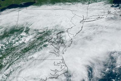
SYNOPSIS: Showers are likely into Friday as a cool front stalls over the area and some heavier downpours are possible. The remains of Tropical Storm Debby will merge with this cool front Friday night and winds will increase some as the low pressure system that was Debby approaches the area Thursday and Friday.
DELMARVA FORECAST
Tonight: Mostly cloudy with passing showers likely. Some areas may see some locally heavy rainfall. Warm and muggy. Low 71°. Wind: E 2-8 mph.
Thursday: Mostly cloudy, and not as hot. Occasional showers and some thundery downpours likely. High 79-81°. Wind: SE 12-24 mph. Beaches reach 76°. Winds near open water may exceed 25 mph.
Thursday Night: Mostly cloudy with passing showers likely. Low 72-73°. Wind: E 9-18 mph.
Friday: Mostly cloudy, and breezy. Occasional showers and some thundery downpours likely. High 83-85°. Wind: SE/S 14-24 mph. Beaches reach 78°.
Forecast Discussion:
Look for cloudy skies with passing showers tonight across the region. Some showers will bring a real downpour. Expect low temps. in the low 70's by daybreak with a light east wind under 9 mph. Winds may be higher near open water though and especially on the Chesapeake Bay.
Thursday looks mostly cloudy with numerous showers and thunderstorms across the area. Occasional heavy downpours are likely with rainfall of over an inch likely in many spots. Winds will turn to the Southeast as a summer cool front sags southward over the area and temperatures will only reach the upper 70's to around 80 degrees.
Beaches will see an onshore flow and stay in the mid 70's all day. Winds will increase in coastal areas to 20 knots later Thursday as the remains of Debby pass to pur west across Virginia. Some coastal flooding ma develop in Somerset and Dorchester counties due to a continuing SE wind flow Thursday into Friday at 15-25 knots.
Friday will remain rather cloudy and turn quite breezy as the low pressure remains of Debby drift into Virginia. We will see passing showers and thunderstorms across the area. Occasional heavy downpours are likely with rainfall of over an inch likely in some spots. Winds will turn to the SE and increase to 15-24 mph in the afternoon hours. Temperatures will reach the low to mid 80's. Beaches will see an onshore flow and stay in the mid 70's all day. Showers will continue into Friday night as a cool front moves across the area.
In the long-range: Skies will clear Saturday after some morning showers as a cool front passes. We should see sunshine, along with cooler and less humid air behind a cool front later Saturday evening into Monday. Look for high temps. in the low/mid 80's with low temps. dropping to the mid 60's Sunday and on Monday. It will turn noticeably less humid Sunday through Tuesday. Wednesday looks mostly sunny with seasonable temperatures.
The average low for early August is 67° and the high is 86°.