


WICOMICO COUNTY, Md. -- Republicans in Maryland say a newly proposed congressional map is a clear attempt by Democrats to gerrymander the state’s districts. The move is drawing pushback from neighbors and political leaders on the Eastern Shore.
On Tuesday, the Governor's Redistricting Advisory Commission voted to recommend a new map concept to Governor Wes Moore (D) and the Maryland General Assembly.
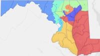
The proposal would significantly reshape Maryland’s 1st Congressional District, currently represented by Republican Rep. Andy Harris. The new map would extend the district across the Chesapeake Bay Bridge and into parts of central Maryland, dramatically altering its geographic and political makeup.
"It will cross the Bay Bridge into sections of two counties that, really, have very little to do with the interest of the Eastern Shore of Maryland," said Harris. "I think that residents of the Eastern Shore should be furious that the governor is doing this."
Some voters on the Eastern Shore say they are frustrated.
"I’m not in favor of it at all, I’m not in favor of our Democratic Governor and I really think that this is something unnecessary right now," said Joi Dowling.
Others, however, say they understand why Maryland is pursuing the changes.
"Maryland is simply reacting to states like Texas, who have done this, and North Carolina, who have done this, to try to get more votes and disenfranchise Democratic voters," said Susan Knowles.
Under the proposed map, parts of Cecil, Harford and Baltimore counties would be removed from the 1st District, while areas of Anne Arundel and Howard counties would be added.
Voter registration data shows a majority of voters in Cecil and Harford counties lean Republican, while a majority in Anne Arundel and Howard counties lean Democratic.
"It didn't even respect the jurisdictional boundaries of Anne Arundel County. It merely passed through Anne Arundel County in order to get into Howard County," said Harris. "That, of course, is a exceedingly partisan gerrymander."
The proposed map now heads to the Maryland General Assembly. Any changes to congressional boundaries must pass both the House of Delegates and the Senate before they can take effect.
Senator Mary Beth Carozza said anything can happen, but she doesn’t think a new map will have a good chance of making it through both chambers. She cites consistent opposition from Senate President Bill Ferguson (D).
"You have our highest ranking leader in the Maryland Senate who is on record voting against this, opposing it from the start," said Carozza. "I think that would make it pretty much an uphill battle in the Maryland Senate."
If the map is approved, Harris said Republicans plan to challenge it in court.
