


Forecast Updated on Saturday, February 21, 2026, at 4:30pm by WBOC Chief Meteorologist Mike Lichniak.
Tonight: Mostly clear to mostly cloudy. Lows: 32-38. Winds: W-NE 5-15 mph.
Sunday: Mostly cloudy with the chance of rain that will transition to snow by the late afternoon and evening hours. Turning windy. Highs: 38-45. Winds: S-NE 10-35+ mph.
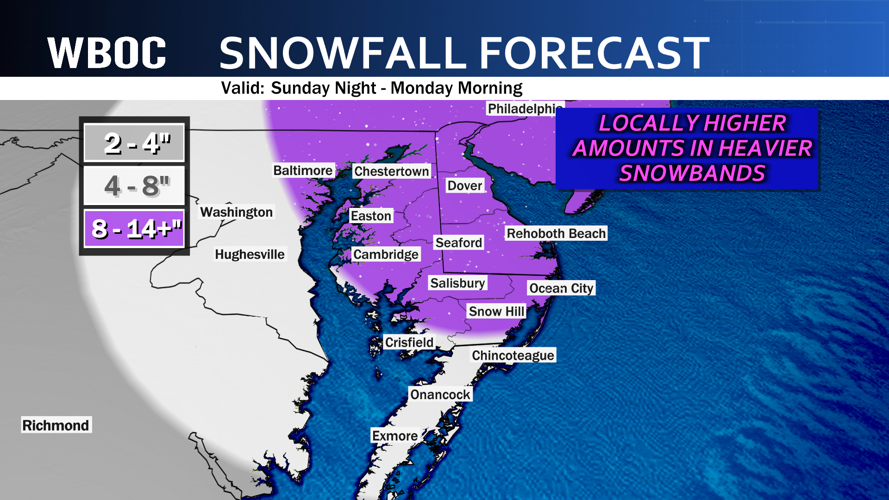
Sunday Night: Snow, heavy at times. Snowfall rates could reach 2”+ per hour at times. Windy. Lows: 28-33. Winds: NE 20-50+ mph.
Monday: Snow ends across Delmarva by the morning hours. It turns mostly cloudy and windy. Highs: 28-35. Winds: NE-NW 15-50+ mph.
Tuesday: Mostly sunny and cold. Highs: 30-36. Winds: NW 10-20+ mph.
The storm of the year will be barreling across Delmarva over the course of Sunday into Sunday night and Monday. The storm will start as rain across Delmarva during the morning hours of Sunday before we transition over to snow. As the transition occurs, we will see some bands of very heavy snow flying across the region. Some estimates have snowfall rates possible over 2+" per hour for a prolonged period of time. A significant amount of snow is expected to fall by the time we wake up on Monday morning with some neighborhoods that could pick up on 2 feet of snow if the heavier snow bands set up in the same area for several hours on end.
I can't stress this enough...this will be very heavy, wet, sticky snow that will act like cement for the majority of the event. Try to shovel as often as you can, but I know that most of this is going to fall in the overnight period. Patience with the snow when you wake up on Monday morning.

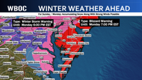
Blizzard conditions are likely with the winds gusting over 50+ mph at times during the night Sunday night into Monday morning. Remember, this will not officially be a blizzard until we reach the criteria of winds sustained over 30+ mph or gusts higher than that with blowing and drifting snow or heavy snow that bring visibility down to under a 1/4 mile for 3 hours or more straight.
On top of all of this, with the wind direction out of the east and northeast...the water is going to get pushed up at our beach towns and in the bays...so be on the lookout for minor to moderate coastal flooding and beach erosion with this storm.
A blast of much colder air will settle for next week with temperatures well below average for early next week.
