

DELMARVA - Snow is falling across Delmarva early Sunday morning as a major winter storm moves in. While the first wave is bringing accumulating snow, WBOC Chief Meteorologist Mike Lichniak says the bigger concern will develop later today as sleet and freezing rain take over in parts of the region.
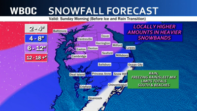
As of Sunday morning, Jan. 25, snow continues to fall steadily on much of the peninsula. Cold air is firmly in place, and temperatures are sitting in the teens and 20s. Once the atmosphere finally moistened up overnight, the snow intensified quickly. Mike says snowfall rates of one to two inches per hour have been possible overnight into the early morning hours, allowing several inches to pile up in many inland areas by sunrise.
What you see early Sunday is not the final story, however. These early totals represent snow before any transition begins, and once sleet or ice starts falling on top, that snow can compress and become harder to measure.
Mike says as the storm evolves late this morning into the afternoon, warmer air pushing in above the surface will set the stage for a changeover from snow to sleet and freezing rain. Along the coast, including Ocean City, Mike expects snow to give way to rain as temperatures rise just enough. That means any early snow at the beaches may wash away as the day goes on.
Inland, especially across northern Delaware and the northern Mid-Shore, Mike says the storm has the potential to turn dangerous and stay that way. Sleet and freezing rain could linger for hours in that zone. Forecast models continue to show the possibility of significant ice buildup there, with some communities at risk for a quarter-inch or more of freezing rain, enough to coat trees and power lines that could trigger outages.
Even if the storm leans more toward sleet than freezing rain, Mike warns that one to three inches of ice pellets on top of snow can still create a hard, frozen mess that makes travel treacherous for days.
All three states, Delaware, Maryland, and Virginia, remain under states of emergency, and Delaware has issued a Level 1 Driving Warning asking drivers to use extra caution and avoid unnecessary travel Sunday. Mike says road conditions are expected to worsen as the day wears on, especially once snow transitions to sleet and freezing rain. He is also watching the backside of the storm late Sunday night into early Monday, when wind gusts could increase and colder air rushes back in. That could lead to a refreeze in spots that see rain, depending on how quickly temperatures drop once precipitation ends.
With colder weather expected to stick around into next week, Mike says cleanup could be slow and any ice left behind will not disappear quickly.
Neighbors on Delmarva are urged to take the storm seriously, limit travel if possible, prepare now for potential power outages, and shovel early before snow turns to sleet or freezing rain and becomes much harder to move.
Stay up to date on the approaching winter storm with radar and hourly forecasts in the WBOC weather app, available for Apple and Android.
Manténgase informado sobre la tormenta invernal que se acerca a nuestra área con la aplicación del tiempo de Telemundo Delmarva, disponible para Apple y Android.
