A Sussex County man has pleaded guilty to transporting a minor with the intent to engage in criminal sexual activity, according to the United States Attorney’s Office for the District of Delaware.
A Sussex County man has pleaded guilty to transporting a minor with the intent to engage in criminal sexual activity, according to the United States Attorney’s Office for the District of Delaware.
Police arrested a Pennsylvania man on gun charges following a road rage incident on South Dupont Highway.

FILE - The Ravenswood Generating Station, which uses natural gas to support the city's electricity needs, is seen in the Queens borough of New York, Aug. 27, 2025. (AP Photo/Ted Shaffrey, File)

The U.S. Department of Education has announced that it is rescinding agreements with five school districts across the country that required the districts to prevent discrimination on the basis of gender identity, including Cape Henlopen School District in Sussex County.

Healthcare network ChristianaCare is looking to expand its presence in Delaware with a new health campus in Georgetown.

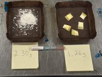
Delaware State Police say they arrested a Philadelphia man on felony charges after a car chase in the morning of January 30.
The Maryland State Fire Marshal has arrested a man after they say he set fire to a home with his mother inside following a fight on Christmas Eve in Hurlock.

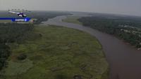
More than 9.2 million acres of land across the Chesapeake Bay watershed are now permanently protected from development, according to newly released data collected through 2024.
Multiple state leaders including Governors Wes Moore, Matt Meyer, Glenn Youngkin, and Josh Shapiro met in Baltimore on Tuesday to approve a revised Chesapeake Bay Watershed Agreement to guide a multi-state and federal effort to restore and protect the Chesapeake Bay.

Salisbury Airport officials are advising travelers to check for flight updates with their airline before heading out for their trips while national flight restrictions are in place due to the U.S. government shutdown.