  • Facebook
  • Twitter
  • LinkedIn
  • YouTube
  • Instagram
  • Sign Up
  • Log In
  • Dashboard
  • Logout
    • My Account
    • Dashboard
    • Profile
    • Saved items
    • Logout
Home
  • About WBOC
  • Our Team
  • Programming
  • Contact Us
  • Careers
  • Internships
  • Policies
  • Report It
  • Get our newsletters
  • WBOC Apps
News
  • Wicomico County
  • Worcester County
  • Somerset County
  • Dorchester County
  • Caroline County
  • Talbot County
  • Queen Annes County
  • Sussex County
  • Kent County
  • Accomack County
  • National News
  • International News
  • Latest Newscasts
  • Video Center
Weather
  • Forecast
  • Radar
  • Satellite
  • On The Waters
  • Weather Cameras
  • Closings
Delmarva Sports Network
Shows
  • DelmarvaLife
  • Outdoors Delmarva
  • Delmarva Home Show
Features
  • Bless Our Children
  • Holiday House
  • Obituaries
  • Heartbeat of Delmarva
  • Proud To Serve
  • The M Report
  • Farming Our Future
  • Farm to Table Scholarship
  • Events: Job Fair
Radio
  • WDEL
  • 100.9% Classic Country
  • 107.1 The Duck
  • 102.5 WBOC FM
  • 93.5 The Beach
  • 107.7 BIG Classic Rock
  • 103.9 & 106.3 Coast Country
  • 93.7 WSTW
  • WXCY 103.7 & 96.9
  • WCEI 96.7
  • 94.3 Dockside
  • Watch Live
  • Apps
  • Contact Us
  • My Account
  • Sign Up
  • Log In
  • Dashboard
  • Logout
    • My Account
    • Dashboard
    • Profile
    • Saved items
    • Logout
  • Facebook
  • Twitter
  • LinkedIn
  • YouTube
  • Instagram
  • 19° Mostly Cloudy
    • Salisbury, MD (21801)

      Today

      Mostly cloudy skies. A few flurries or snow showers possible. High near 25F. Winds N at 10 to 15 mph..

      Tonight

      Cloudy. A few flurries or snow showers possible. Low 14F. Winds N at 15 to 25 mph.

      Updated: January 31, 2026 @ 11:49 am

    • Full Forecast
site-logo
Watch Live

Newscast Schedule

View Programming Schedule
site-logo
  • 19°
  • Home
  • News
    • Wicomico County
    • Worcester County
    • Somerset County
    • Dorchester County
    • Caroline County
    • Talbot County
    • Queen Anne's County
    • Sussex County
    • Kent County
    • Accomack County
    • National News
    • International News
    • Latest Newscasts
    • Video Center
    • Report It
  • Weather
    • Forecast
    • Radar
    • Satellite
    • On The Waters
    • Weather Cameras
    • Closings
  • Delmarva Sports Network
  • Shows
    • DelmarvaLife
    • Outdoors Delmarva
    • Delmarva Home Show
  • Features
    • Bless Our Children
    • Holiday House
    • Obituaries
    • Heartbeat of Delmarva
    • The M Report
    • Proud To Serve
    • Farming Our Future
    • Farm to Table Scholarship
    • Jefferson Awards
    • Delmarva Experts
    • Events: Job Fair
  • Radio
    • WDEL
    • 100.9% Classic Country
    • 107.1 The Duck
    • 93.5 The Beach
    • 107.7 BIG Classic Rock
    • 103.9 & 106.3 Coast Country
    • 102.5 WBOC FM
    • 93.7 WSTW
    • WXCY 103.7 & 96.9
    • WCEI 96.7
    • 94.3 WINX
  • About Us
    • About WBOC
    • Our Team
    • Channel Finder
    • Apps
    • Contact Us
    • Get our newsletters
    • Careers
    • Internships
    • Policies
    • WBOC Solar Farm
  • Report It

WINTER STORM

Download Weather App

Broadcast Schedule

On air schedule

Weather Alert

Weather Alert

...SMALL CRAFT ADVISORY REMAINS IN EFFECT UNTIL 6 PM EST THIS
EVENING...
...GALE WARNING REMAINS IN EFFECT FROM 6 PM THIS EVENING TO
MIDNIGHT EST SUNDAY NIGHT...
...HEAVY FREEZING SPRAY WARNING REMAINS IN EFFECT FROM 1 AM TO
10 AM EST SUNDAY...

* WHAT...For the Small Craft Advisory, north winds 10 to 20 kt
with gusts up to 25 kt. For the Gale Warning, north winds 25 to
35 kt with gusts up to 45 kt and waves 3 to 6 ft. For the Heavy
Freezing Spray Warning, heavy freezing spray at a rate of 2 cm
per hour or greater which may rapidly accumulate on vessels.

* WHERE...Chesapeake Bay from Drum Point MD to Smith Point VA,
and Tangier Sound and the inland waters surrounding
Bloodsworth Island.

* WHEN...For the Small Craft Advisory, until 6 PM EST this
evening. For the Gale Warning, from 6 PM this evening to
midnight EST Sunday night. For the Heavy Freezing Spray
Warning, from 1 AM to 10 AM EST Sunday.

* IMPACTS...Operating a vessel in heavy freezing spray is
hazardous. Freezing spray may render mechanical and electronic
components inoperative. Rapid ice accretion on decks and
superstructures may result in a catastrophic loss of
stability. Strong winds will cause hazardous waves which could
capsize or damage vessels.

PRECAUTIONARY/PREPAREDNESS ACTIONS...

Mariners should prepare for dangerous accumulation of ice on
their vessel. If possible, remain in port, avoid the warning area
or conduct mitigation.

Mariners should alter plans to avoid these hazardous conditions.
Remain in port, seek safe harbor, alter course, and/or secure the
vessel for hazardous conditions.

&&

Weather Alert

...WINTER WEATHER ADVISORY REMAINS IN EFFECT UNTIL 4 PM EST SUNDAY...

* WHAT...Snow. Snow accumulations up to one inch. Winds gusting as
high as 50 mph.

* WHERE...Inland Worcester, Maryland Beaches, Somerset, and Wicomico
Counties.

* WHEN...Until 4 PM EST Sunday.

* IMPACTS...Plan on slippery road conditions. Gusty winds could
bring down tree branches.

PRECAUTIONARY/PREPAREDNESS ACTIONS...

Slow down and use caution while traveling. Call 511 for road
information.

&&

Weather Alert

...COLD WEATHER ADVISORY NOW IN EFFECT UNTIL 10 AM EST SUNDAY...
...WIND ADVISORY REMAINS IN EFFECT FROM 10 PM THIS EVENING TO 4 PM
EST SUNDAY...
...EXTREME COLD WATCH IS CANCELLED...

* WHAT...For the Cold Weather Advisory, very cold wind chills as low
as 3 below expected. For the Wind Advisory, north winds 20 to 30
mph with gusts up to 50 mph expected.

* WHERE...Inland Worcester, Maryland Beaches, Somerset, and Wicomico
Counties.

* WHEN...For the first Cold Weather Advisory, second Cold Weather
Advisory, and third Cold Weather Advisory, until 10 AM EST Sunday.
For the Wind Advisory, from 10 PM this evening to 4 PM EST Sunday.

* IMPACTS...Gusty winds will blow around unsecured objects. Tree
limbs could be blown down and a few power outages may result. The
cold wind chills as low as zero could result in hypothermia if
precautions are not taken.

PRECAUTIONARY/PREPAREDNESS ACTIONS...

Winds this strong can make driving difficult, especially for high
profile vehicles. Use extra caution.

Use caution while traveling outside. Wear appropriate clothing, a
hat, and gloves.

&&

Closings

Click here to view closings and delays

Advanced Search Close Search
From
To
Close Search
Flu season is ramping up on Delmarva
Latest News

Flu season is ramping up on Delmarva

  • Kyle Orens
  • Updated Jan 6, 2026

WICOMICO COUNTY, Md. -- If it feels like everyone around you is getting sick, you're not imagining it. A recent report from Maryland's Departm…

+2
Opioid overdose calls drop in Salisbury following expanded outreach
Latest News

Opioid overdose calls drop in Salisbury following expanded outreach

  • Kyle Orens
  • Updated Dec 29, 2025

SALISBURY, Md. -- Opioid overdoses in Salisbury are trending in the right direction, with emergency calls dropping significantly over the past two years. City leaders credit the decline to increased collaboration between local agencies.

The Wicomico County Health Department is moving out of Downtown Salisbury
Latest News

The Wicomico County Health Department is moving out of Downtown Salisbury

  • Kyle Orens
  • Updated Dec 17, 2025

WICOMICO COUNTY, Md. -- The Wicomico County Health Department has outgrown the Seth H. Hurdle Health Center at 108 East Main Street. It is now slated to move into a new facility on the outskirts of the county. 

"Rhino Tranq" present in Wicomico County illicit drugs
Latest News

"Rhino Tranq" present in Wicomico County illicit drugs

  • Alexis Griess
  • Updated Dec 4, 2025

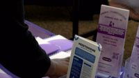
A dangerous animal sedative has made its way into the illicit drug supply. The Wicomico County Health Department says Medetomidine, also known as "Rhino Tranq," has been found in 10% of the drugs they've tested.

Fox Tests Positive for Rabies in Wicomico County
Latest News

Fox Tests Positive for Rabies in Wicomico County

  • Ryan Mackesey
  • Updated Oct 28, 2025

The Wicomico County Health Department says a fox found near Catchpenny Road in Quantico has tested positive for rabies.

Wicomico County to give away free gun safes
Latest News

Wicomico County to give away free gun safes

  • Bees Beesley
  • Oct 23, 2025

Wicomico County Health Department officials will spread awareness for firearm storage and give away safes, as supplies last, at several locations in the coming months.

Bat tests positive for rabies in Wicomico County
Latest News

Bat tests positive for rabies in Wicomico County

  • Bees Beesley
  • Aug 26, 2025

The Wicomico County Health Department is recommending tips to stay safe after officials say a bat tested positive for rabies in the area of Foxchase Drive Monday. 

UPDATE: Bacteria Advisory at Tyaskin Beach
Latest News

UPDATE: Bacteria Advisory at Tyaskin Beach

  • Colby Moore, Jana Ruark
  • Updated Jul 18, 2025

Officials are advising certain groups to avoid the water at the beach.

Raccoon Tests Positive for Rabies in Wicomico County
Latest News

Raccoon Tests Positive for Rabies in Wicomico County

  • Colby Moore
  • Updated Jun 4, 2025

Officials say a raccoon tested positive rabies in the area of Pirate's Wharf on Whitehaven Road, in Quantico.

Perdue Continues Testing, Water Filter Installation at PFAS-Affected Properties
Latest News

Perdue Continues Testing, Water Filter Installation at PFAS-Affected Properties

  • Hunter Landon
  • Updated Dec 19, 2024

WICOMICO COUNTY, Md. - Progress is being made by Perdue Farms after PFAS (Per- and Polyfluoroalkyl Substances) or "forever chemicals" were det…

  •  
  • 1 of 6
  •  
site-logo
  • Facebook
  • Twitter
  • LinkedIn
  • YouTube
  • Instagram

Sections

  • Latest Newscasts
  • Local News
  • Weather
  • Features
  • DelmarvaLife
  • Outdoors Delmarva
  • Delmarva Home Show
  • CoastTV
  • Telemundo Delmarva
  • Delmarva Sports Network
  • Video Center

Services

  • Search
  • Pay My Bill
  • Advertise With Us
  • Contact Us
  • Careers
  • Internships

Browser Compatibility

Your browser is out of date and potentially vulnerable to security risks.
We recommend switching to one of the following browsers:

Microsoft Edge Google Chrome Firefox
FCC Public File Applications & Related Materials EEO Public File Report FCC Closed Captioning Concerns Children's Programming Transparency Requirements for Group Health Plans
© Copyright 2026 WBOC TV 1729 N. Salisbury BLVD, Salisbury, MD  | Terms of Use  | Privacy Policy
Powered by BLOX Content Management System from BLOX Digital.