

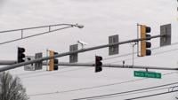
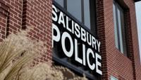
SALISBURY, Md. -- Drivers in Salisbury could soon feel the financial impact of running red lights. Cameras installed at what the city calls “h…


Officials say both southbound lanes will close from North Park Drive to South Park Drive from 7 a.m. to 5 p.m. on Dec. 8 and 9.

SALISBURY, Md. -- City leaders continue to debate the effectiveness and long-term sustainability of the Housing First program.

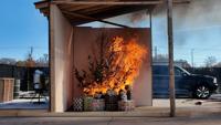
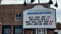
Salisbury Fire Marshal: Adding fire safety to your holiday to-do list should be a priority this year
WICOMICO COUNTY, Md. -- The holiday season is right around the corner, and with it comes a handful of hazards that can quickly turn a joyous occasion into a nightmare.


The City of Salisbury has announced that Armstrong Parkway from Marvel Road to W. Naylor Mill Road will be closed to all through traffic today for replacement of a fire hydrant.

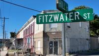
SALISBURY, Md. -- A section of rowhouses on Fitzwater Street has fallen into disrepair, but that will soon change. Major renovation work aims to give the nearly historic homes a "fresh start."


SALISBURY, Md. -- The Executive Director of the Christian Shelter in Salisbury is participating in a nationwide initiative called "Conversations on a Bench." The initiative aims to spread awareness about the city's homeless population.

SALISBURY, Md. -- The City of Salisbury injected itself into conversations surrounding a potential partnership between Wicomico County and United States Immigration and Customs Enforcement earlier this month. Now, there are questions as to whether the city can or should get involved.


The City of Salisbury announced plans for a public meeting Oct. 2 to update neighbors on cleanup efforts at the 317-325 Lake Street Brownfield property.

SALISBURY, Md. -- Carroll Street in Salisbury should officially return to its previous design this week, albeit with a slightly delayed timeline.